
Desert garden
| Desert garden | ||
|---|---|---|
 Desert garden with cellar forest tower, in the foreground the tower of Jesberg Castle |
||
| height | 675.3 m above sea level NHN | |
| location | near Jesberg ; District of Waldeck-Frankenberg and Schwalm-Eder district , Hesse ( Germany ) | |
| Mountains | Hoher Kellerwald , West Hessian highlands | |
| Dominance | 36 km → Bollerberg or Heidkopf ( Rothaargebirge ) | |
| Notch height | 315 m ↓ 5 km east of Battenberg | |
| Coordinates | 51 ° 0 '57 " N , 9 ° 5' 2" E | |
|
||
| particularities | - the highest mountain in the Kellerwald , in the Kellerwald-Edersee nature park and in the Schwalm-Eder district ; - Ringwall of Heidelburg - Kellerwald Tower observation tower |
|
 View from the south-southwest from the Burgholz mountain ( 379.1 m ) to the Kellerwald with Hohem Lohr ( 656.7 m , left), Jeust ( 585 m , center) and Wüstegarten ( 675.3 m , right); in front the Gilserberger heights |
||

The desert garden , also called the high cellar , is 675.3 m above sea level. NHN is the highest mountain in the West Hessian mountain and depression region , the Kellerwald , the Kellerwald-Edersee nature park and the Schwalm-Eder district in northern Hesse .
The Kellerwaldturm observation tower is located on the hilltop, which is surrounded by the Heidelberg ramparts .
geography
location
The desert garden is located in the south of the Kellerwald on the border between the communities of Jesberg in the Schwalm-Eder district and Haina in the Waldeck-Frankenberg district . It is part of the Kellerwald-Edersee Nature Park. The nearest town, Haddenberg , a district of Haina, is on the west side. Parts of the Hohe Keller located northeast of the mountain belong to the municipality of Bad Zwesten and the city of Bad Wildungen .
The desert garden is bordered by the left Schwalm tributaries Urff in the north and Gilsa in the south and east and by the left Gilsa tributary north in the southwest. Beyond or south of the Gilsa, the Upper Hessian threshold joins the Hemberg ridge .
Natural allocation
The desert garden, together with the adjoining secondary peaks Hunsrück ( 635.9 m ) and Sauklippe ( 584.4 m ) to the north-east, form the Keller mountain ridge (also known as the Hoher Keller ). This belongs in the natural spatial main unit group West Hessisches Berg- und Senkenland (No. 34), in the main unit Kellerwald (344) and in the subunit Hoher Kellerwald (344.0) to the natural area Jeust and Keller (344.00).
geology
Parts of the ridge consist of quartzite with cliffs and block fields. The rock formations on and on the mountain include the Mausefalle , the Wanderklippe , the Hunsrück , the Birkenstein and the Exhelmer Steine .
Protected areas
The Desert Garden is part of the existing since 1971 and 233.00 square kilometers of protected landscape Kellerwald (LSG no. 329111). The mountain is located in the fauna-flora-habitat area Hoher Keller (FFH no. 4920-304).
Ringwall of Heidelberg Castle

The remains of a ring wall can be seen on the top of the desert garden . The stone wall is related to the conflicts of the Conradines against liudolfingischen Saxony Dukes, first as late Carolingian counts, then the holder of the kingship under I. Konrad to see. It is very likely that it dates from the 9th century AD. A text plaque on the desert garden, on the other hand, dates its age to the Iron Age and indicates its use as a fortified place of defense and cult site.
The oval measures 200 mx 140 m. The wall still preserved today is up to 7 m wide in places. In 1963 it was examined archaeologically. It was found that the stones form an external and internal front. Wooden built-in or superstructures could not be detected. There were also no finds that point to an earlier settlement of the place. A quartzite block exhibited in the entrance area of the Jesberg town hall with a hemispherical recess is said to have been found on the summit. It is often interpreted as evidence of a Celtic use of the desert garden as a place of worship or sacrificial site . However, there are no finds in Lower Hesse that would suggest the presence of a Celtic population.
In 1475 the desert garden was first mentioned as the desert garden . In the 16th and 17th centuries, the ramparts called Heidelburg with the names Heulburgk, Hulnburgk, Hedelberg and Heidelburg are mentioned in writings and documents.
Kellerwald Tower
Tower description

The 28 m high Kellerwald Tower, which was officially inaugurated on May 9, 2004 , has stood on the summit of the desert garden since autumn 2003 . It replaces the 18 m high observation tower from 1971.
The cellar forest tower was built from resistant larch heartwood. It has 123 steps. Because of its deliberately flexible, but stable construction in diagonal double-tong construction, the tower gives way in cross winds or when loaded with lateral kinks. The visitor notices this with a slight sway.
Benches and tables were set up outside at the foot of the observation tower. The ground floor of the tower serves as a shelter , in which there are further benches and information boards about the flora , fauna , geology and history of the cellar forest.
In 2006 the first cracks appeared on the plywood beams . As a result, from April 2009, entering the tower was prohibited for safety reasons. After a new report in May 2010 came to the conclusion that the stability of the tower is guaranteed, it has since been allowed to be entered by up to 15 people at the same time. A legal dispute over who is responsible for the damage or construction defects is still pending.
In 2013, plans by the German Weather Service (DWD) became known to erect a new weather radar with a viewing platform on the desert garden near the summit . The planning takes place in cooperation between the DWD and the Wiesbaden wind power project developer ABO Wind . A new radar would make the radar located around 38 km northwest of the mountain and 2.5 km southwest of Flechtdorf (district of Diemelsee ) superfluous. This blocks numerous wind farm plans. In March 2016, ABO Wind announced that it had received a building permit for the new radar. The plan is for the first nationwide weather radar with a viewing platform to be located at a height of 39 m. However, the project is subject to financing. The wind farms that have so far been blocked by the radar in Flechtdorf would first have to prove that they can be approved. In the case of the construction of such a reinforced concrete structure, the basement forest tower in need of renovation could be demolished.
Possibility of viewing
The all-round view can be enjoyed from the viewing platform (at a height of 25 m or 700 m ):
To the north you can see over the Kellerwald to the Ederhöhen, which rise up to 626.4 m in the Traddelkopf. To the northeast you can see the Habichtswald , with the television tower on the Essigberg and the Hercules on the Karlsberg. In addition, the Kaufunger Wald and the Hohe Meißner can be seen, and with particularly clear visibility conditions you can even see the Brocken in the Harz Mountains with binoculars . The confluence of the Gilsa with the Schwalm can also be seen in the foreground towards the northeast, and behind it the observation tower on the Altenburg mountain ( 432.7 m ).
The Knüll rises in an east-south- east direction, the Rhön in the south-east and the Vogelsberg in the south , to which one looks over the Hemberg ridge in the foreground . When the weather is very clear you can see the Großer Feldberg in the Taunus in the south-southwest . In the southwest lies the Westerwald . To the west you look past the television tower on the Hohen Lohr to the Rothaargebirge , the Hoch- Sauerland and the Upland .

View from the west with the village of Haddenberg

Exhelmer Steine (rock formation on the western slope of the desert garden)

Exhelmer stones with summit cross and book

Mausefalle (rock formation on the western slope of the desert garden)
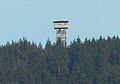
Kellerwald Tower from afar
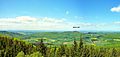
View from the Kellerwald Tower to the west
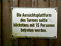
Information sign on the ascent of the Kellerwald tower


Leisure and sport opportunities
The leisure and sports options at the desert garden include: mountain biking , Nordic walking , horse riding , cross-country skiing and hiking .
Sections of the Kellerwaldsteig (156 km long hiking trail in the Kellerwald-Edersee nature park) and student path (252 km long hiking trail that leads from Göttingen via Kassel to Gießen ) run across the desert garden and past the Kellerwald Tower . The Lulluspfad (184 km long long-distance hiking trail that connects the Edersee with the Rennsteig ) crosses the Hohe Keller in its northeastern part.
Hiking trails start in or near Densberg , Jesberg , Bergfreiheit and Haddenberg , for example . The shortest ascent to the desert garden and the Kellerwald tower starts at the parking lot near Haddenberg. From there to the tower about 3 km through extensive beech forest, but also past conifers . There are about 225 m difference in altitude to be overcome. Follow the “B4” hiking trail or the Kellerwaldsteig. During the ascent (approx. 45 min.) You pass a woodworker's hut , the rock formations Exhelmer Steine and Mausefalle and the ring wall on the ridge. In the lower and middle area of the mountain you walk on a wide path, in the upper area on a path .
Directions

The Kellerwald Tower can be visited by the shortest route as follows: If you come from the north or south on the B 3 , turn off the main road in Jesberg or Gilserberg . From Jesberg you drive via Densberg to Schönstein or from Gilserberg via Moischeid to Schönstein. You then reach the village of Haddenberg via Dodenhausen and turn right onto a parking lot on a hill at the highest point of the L 3296 state road . On a field path you can walk to the edge of the forest, from there on the marked hiking route to the summit.
Individual evidence
- ↑ a b c d Map services of the Federal Agency for Nature Conservation ( information )
- ↑ Dominances and celebrities , on highrisepages.de
- ↑ Martin Bürgener: Geographical Land Survey: The natural spatial units on sheet 111 Arolsen. Federal Institute for Regional Studies, Bad Godesberg 1963. → Online map (PDF; 4.1 MB)
-
↑ a b c Rock formation names - Exhelmer Steine and Exhelmerstein :
- Exhelmer Steine (according to the signs on site)
- Exhelmerstein (according to the topographic maps of the referenced map services of the Federal Office for Nature Conservation and topographic leisure map Waldecker Land - National and Nature Park Kellerwald / Edersee, Nature Park Diemelsee , M = 1: 50,000, published by the Hessisch-Waldeckischer Gebirgs- und Heimatverein and the Hessische Landesvermessungsamt (TF 50-WL), 2004, ISBN 3894463201 ) - ^ K. Weidemann: Niederhessen in the early and high Middle Ages. In: Guide to early and prehistoric monuments , published by the Römisch-Germanisches Zentralmuseum Mainz in connection with the Northwest German and the West and South German Association for Antiquity Research, in cooperation with the Department for Prehistory in the State Office for Monument Preservation Hessen and the Department Prehistory and Early History of the State Art Collections Kassel - Vol. 50, 1982, p. 203.
- ↑ Kellwerwald Tower has reopened , HNA of May 11, 2010
- ↑ a b Kellerwald Tower: Construction of the weather station at Wüstegarten is not yet certain , HNA from March 18, 2014
- ↑ Weather radar is moving, wind turbines could come , HNA from August 26, 2015, accessed on March 23, 2016, on hna.de.
- ↑ Length information using the measure distance function on Google Maps
- ↑ Schwalm-Eder-Kreis approves the construction of a weather radar tower in the Kellerwald , from March 23, 2016, accessed on March 23, 2016, on abo-wind.com
- ↑ Nature conservation checks the tower construction of the weather service at Wüstegarten , HNA of December 17, 2013
literature
- Upper Hesse, Kurhessen and Waldeck. Karl Thiemig Verlag, Munich 1981, ISBN 3-521-00286-1 , p. 160. (Grieben travel guide, volume 230)
- Eduard Brauns: Hiking and travel guide through North Hesse and Waldeck. Bernecker Verlag, Melsungen 1971, DNB 456180117 , p. 180.
- Karl E. Demandt: History of the State of Hesse. Johannes Stauda Verlag, Kassel 1980, ISBN 3-7982-0400-4 , pp. 88-89.
Web links
- 360-degree panorama from the Kellerwald Tower (labeling of visual targets can be activated), on panorama-photo.net