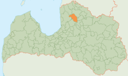
Kocēni district
| Kocēni district | ||
|---|---|---|
 |
||
| Symbols | ||
|
||
| Basic data | ||
| Country | Latvia | |
| Capital | Kocēni | |
| surface | 498.1 km² | |
| Residents | 7018 (2010) | |
| density | 14 inhabitants per km² | |
| founding | 2009 | |
| ISO 3166-2 | LV-045 | |
| Website | www.kocenunovads.lv (Latvian) | |
Coordinates: 57 ° 31 ' N , 25 ° 20' E
The Kocēni District (Kocēnu novads) is located in northern Latvia .
geography
The rural area is located southwest of the city of Valmiera . The Gauja forms the eastern border . At 127 meters, the Zilaiskalns elevation is one of the highest in the region.
population
The district with 7018 inhabitants (2010) consists of the five municipalities (pagasts) Bērzaine, Dikļi, Vaidava, Zilākalns and the administrative center Kocēni .
