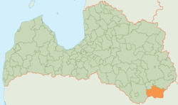
Krāslava district
| Krāslava district | ||
|---|---|---|
 |
||
| Symbols | ||
|
||
| Basic data | ||
| Country | Latvia | |
| Capital | Krāslava | |
| surface | 1,078.4 km² | |
| Residents | 19,811 (2010) | |
| density | 18 inhabitants per km² | |
| founding | 2009 | |
| ISO 3166-2 | LV-047 | |
| Website | www.kraslava.lv (Latvian) | |
| Winter at Lake Sivers | ||
Coordinates: 55 ° 54 ' N , 27 ° 10' E
The District Krāslava ( Krāslavas novads ; Latgalian : Kruoslovys nūvods ) is located in the south-east of Latvia , on the border with Belarus in the historic landscape Latgale .
geography
The Düna flows through the area . There are also many lakes in the district area. The largest are the Sivers Lake and Lake Drīdzis .
structure
In 2010, 19,811 inhabitants lived in the Krāslava district, which is divided into twelve parishes (pagasts):
- Auleja
- Indra
- Izvalta
- Kalnieši
- Kaplava
- Kombuļi ( Kumbuļs )
- Krāslava Land ( Kruoslova )
- Krāslava town (administrative center)
- Piedruja
- Robežnieki
- Skaista
- Ūdrīši
Personalities
- Józef Broel-Plater (* 1890 in Kombuļi; † 1941 Dachau concentration camp) Polish bobsledder.

