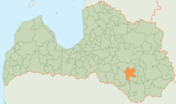
Līvāni district
| Līvāni district | ||
|---|---|---|
 |
||
| Symbols | ||
|
||
| Basic data | ||
| Country | Latvia | |
| Capital | Līvāni | |
| surface | 624.6 km² | |
| Residents | 14,046 (2010) | |
| density | 22 inhabitants per km² | |
| founding | 1999 | |
| ISO 3166-2 | LV-056 | |
| Website | www.livani.lv (Latvian) | |
Coordinates: 56 ° 22 ' N , 26 ° 11' E
The Līvāni District (Līvānu novads) is located in Latvia .
geography
The district is located in the southeast of the country, on the right side of the Daugava . Via two ferry stations, Līvāni-Dignaja and Dunava-Tadenavu, it is possible to get to the neighboring communities of the Jēkabpils district to the west . The Riga-Daugavpils railway and the A6 main state road run through the area , as does the Dubna River , which flows into the Daugava here.
population
In the course of an administrative reform, the city formed an administrative community with two rural communities in 1999, which three more communities joined in 2009. In 2010, 14046 inhabitants were registered.
Web links
Commons : Līvāni Municipality - collection of images, videos and audio files
Individual evidence
- ↑ http://www.livani.lv/page/332 Berkswebseite (accessed on January 19, 2020)
