Montereale
| Montereale | ||
|---|---|---|

|
|
|
| Country | Italy | |
| region | Abruzzo | |
| province | L'Aquila (AQ) | |
| Coordinates | 42 ° 31 ' N , 13 ° 15' E | |
| height | 948 m slm | |
| surface | 104.44 km² | |
| Residents | 2,329 (Dec 31, 2019) | |
| Population density | 22 inhabitants / km² | |
| Post Code | 67015 | |
| prefix | 0862 | |
| ISTAT number | 066056 | |
| Popular name | Monterealesi | |
| Patron saint | Andrew of Montereale | |
| Website | Montereale | |
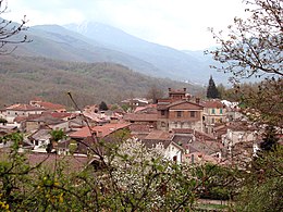
Montereale is an Italian commune ( comune ) with 2329 inhabitants (as of December 31, 2019) in the province of L'Aquila in Abruzzo . The municipality is located about 30 kilometers northwest of L'Aquila am Aterno and borders directly on the province of Rieti . Montereale is part of the Gran Sasso and Monti della Laga National Park and belongs to the Comunità Montana Amiternina .
history
The settlement of Montereale goes back to the founding of the town of Maronea by the Pelasgians , which was destroyed in 550 AD. The Lombards established a new settlement in the 6th century, which was known as Monte Regalis in the Middle Ages . In 1703 an earthquake destroyed Montereale and claimed around 800 victims. The 2009 earthquake also caused numerous damage to the community.
traffic
The Strada Statale 260 Picente leads through the municipality from L'Aquila to Lake Scandarello near Amatrice .
Web links
Individual evidence
- ↑ Statistiche demografiche ISTAT. Monthly population statistics of the Istituto Nazionale di Statistica , as of December 31 of 2019.


