
Montigny-en-Ostrevent
| Montigny-en-Ostrevent | ||
|---|---|---|
_-Nord-France.svg)
|
|
|
| region | Hauts-de-France | |
| Department | North | |
| Arrondissement | Douai | |
| Canton | Aniche | |
| Community association | Cœur d'Ostre event | |
| Coordinates | 50 ° 22 ′ N , 3 ° 11 ′ E | |
| height | 18-40 m | |
| surface | 5.42 km 2 | |
| Residents | 4,801 (January 1, 2017) | |
| Population density | 886 inhabitants / km 2 | |
| Post Code | 59182 | |
| INSEE code | 59414 | |
| Website | http://www.montigny-en-ostrevent.com | |

Montigny-en-Ostrevent is a French municipality with 4801 inhabitants (at January 1, 2017) in the department of Nord in the region of Hauts-de-France . It belongs to the Arrondissement of Douai and the Canton of Aniche .
Neighboring municipalities of Montigny-en-Ostrevent are Pecquencourt in the northeast, Masny in the southeast, Loffre in the south, Guesnain in the southwest, Sin-le-Noble in the west and Lallaing in the northwest.
Population development
| year | 1962 | 1968 | 1975 | 1982 | 1990 | 1999 | 2007 |
| Residents | 5657 | 5756 | 5660 | 5489 | 5452 | 4848 | 4785 |
Attractions
See also: List of Monuments historiques in Montigny-en-Ostrevent
- Montmorency Castle (12th century, Monument historique )
- Lambrecht Castle (1853)
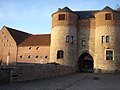
Montmorency Castle

Lambrecht Castle


Personalities
- Felix Lambrecht (1819–1871), politician, builder of Montigny Castle
- Albert Calmette (1863–1933), doctor and bacteriologist, bought 21 hectares from Felix Lambrecht's property in 1904 to build a tuberculosis sanatorium.
literature
- Le Patrimoine des Communes du Nord. Flohic Editions, Volume 1, Paris 2001, ISBN 2-84234-119-8 , pp. 701-702.
Web links
Commons : Montigny-en-Ostrevent - collection of images, videos and audio files
Wikisource: Montigny in the Topographia Circuli Burgundici (Mathäus Merian) - sources and full texts