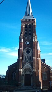
Dechy
| Dechy | ||
|---|---|---|

|
|
|
| region | Hauts-de-France | |
| Department | North | |
| Arrondissement | Douai | |
| Canton | Aniche | |
| Community association | Douaisis | |
| Coordinates | 50 ° 21 ′ N , 3 ° 8 ′ E | |
| height | 18-46 m | |
| surface | 9.27 km 2 | |
| Residents | 5,324 (January 1, 2017) | |
| Population density | 574 inhabitants / km 2 | |
| Post Code | 59187 | |
| INSEE code | 59170 | |
| Website | http://www.ville-dechy.fr/ | |
Dechy is a French municipality with 5324 inhabitants (at January 1, 2017) in Nord in the region of Hauts-de-France .
geography
Dechy is located in the northern French coalfield , 40 kilometers south of Lille . The neighboring communes are: Lallaing , Montigny-en-Ostrevent , Guesnain , Cantin , Férin and Gœulzin .
history
In 1610 General Tilly set up his headquarters here.
| Population development | |||||||
|---|---|---|---|---|---|---|---|
| year | 1962 | 1968 | 1975 | 1982 | 1990 | 1999 | 2010 |
| Residents | 6,348 | 6.156 | 6,630 | 5,720 | 5,464 | 5,283 | 5,135 |
coat of arms
The coat of arms of the parish of Dechy is split ; in front a half-flying black eagle on a golden background; behind on an azure background golden lilies.
Town twinning
Dechy has a town partnership, which was concluded in the time of the GDR, with the town of Weißensee in Thuringia.
Personalities
- Séverine Vandenhende (* 1974), judoka
literature
- Le Patrimoine des Communes du Nord. Flohic Editions, Volume 1, Paris 2001, ISBN 2-84234-119-8 , pp. 648-649.
Web links
Commons : Dechy - collection of images, videos and audio files
- Monuments historiques (objects) in Dechy in the base Palissy of the French Ministry of Culture

