
Warlaing
| Warlaing | ||
|---|---|---|
.svg)
|
|
|
| region | Hauts-de-France | |
| Department | North | |
| Arrondissement | Douai | |
| Canton | Sin-le-Noble | |
| Community association | Cœur d'Ostre event | |
| Coordinates | 50 ° 25 ′ N , 3 ° 20 ′ E | |
| height | 16-19 m | |
| surface | 3.89 km 2 | |
| Residents | 579 (January 1, 2017) | |
| Population density | 149 inhabitants / km 2 | |
| Post Code | 59870 | |
| INSEE code | 59642 | |

Warlaing is a French municipality with 579 inhabitants (at January 1, 2017) in Nord in the region of Hauts-de-France . It belongs to the Arrondissement of Douai and the canton of Sin-le-Noble .
Neighboring communities of Warlaing are Tilloy-lez-Marchiennes in the north, Hasnon in the east, Hélesmes in the southeast, Wandignies-Hamage in the south and Marchiennes in the west. The canalized Scarpe flows through the southern municipality.
Population development
| year | 1962 | 1968 | 1975 | 1982 | 1990 | 1999 | 2007 |
| Residents | 431 | 359 | 352 | 340 | 381 | 461 | 562 |
Attractions
- Church of the Assumption
- Warlaing castle ruins
See also: List of Monuments historiques in Warlaing
literature
- Le Patrimoine des Communes du Nord. Flohic Editions, Volume 2, Paris 2001, ISBN 2-84234-119-8 , pp. 1130-1131.
Web links
Commons : Warlaing - collection of images, videos and audio files

Town Hall (Mairie) in Warlaing

Notre-Dame-de-l'Assomption
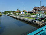
Lock on the Sarpe
_mairie.JPG)
.JPG)
_%C3%A9cluse_de_la_Scarpe.JPG)