Lauwin Planque
| Lauwin Planque | ||
|---|---|---|

|
|
|
| region | Hauts-de-France | |
| Department | North | |
| Arrondissement | Douai | |
| Canton | Douai | |
| Community association | Douaisis | |
| Coordinates | 50 ° 23 ' N , 3 ° 3' E | |
| height | 22-40 m | |
| surface | 3.67 km 2 | |
| Residents | 1,679 (January 1, 2017) | |
| Population density | 457 inhabitants / km 2 | |
| Post Code | 59552 | |
| INSEE code | 59334 | |
| Website | http://www.lauwin-planque.com/ | |
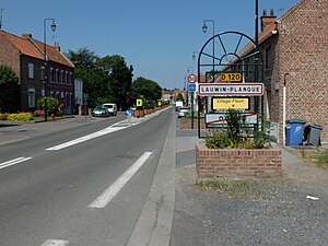
 Entrance to Lauwin-Planque |
||
Lauwin-Planque is a northern French municipality with 1679 inhabitants (as of January 1 2017) in the department Nord , region of Hauts-de-France and belongs to Arrondissement Douai and Canton Douai (2015: Canton Douai-Sud-Ouest ). The inhabitants are called Lauwinois .
geography
Lauwin-Planque lies on the Escrebieux, a tributary of the canalized Scarpe . Lauwin-Planque is surrounded by the neighboring communities of Flers-en-Escrebieux in the north, Douai in the east, Cuincy in the south and southwest and Esquerchin in the south and west.
Population development
| 1962 | 1968 | 1975 | 1982 | 1990 | 1999 | 2006 | 2012 | |
|---|---|---|---|---|---|---|---|---|
| 960 | 948 | 918 | 1,247 | 1,775 | 1,900 | 1,818 | 1,784 | |
| Sources: Cassini and INSEE | ||||||||
Attractions
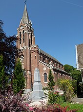
- Saint-Ranulphe Church
literature
- Le Patrimoine des Communes du Nord. Flohic Editions, Volume 1, Paris 2001, ISBN 2-84234-119-8 , p. 696.
Web links
Commons : Lauwin-Planque - collection of images, videos and audio files

