
Salignac (Alpes-de-Haute-Provence)
| Salignac | ||
|---|---|---|

|
|
|
| region | Provence-Alpes-Cote d'Azur | |
| Department | Alpes-de-Haute-Provence | |
| Arrondissement | Forcalquier | |
| Canton | Sisteron | |
| Community association | Jabron-Lure-Vançon-Durance | |
| Coordinates | 44 ° 9 ' N , 5 ° 59' E | |
| height | 431-802 m | |
| surface | 14.42 km 2 | |
| Residents | 634 (January 1, 2017) | |
| Population density | 44 inhabitants / km 2 | |
| Post Code | 04290 | |
| INSEE code | 04200 | |
 Mairie Salignac |
||

Salignac is a French municipality with 634 inhabitants (at January 1, 2017) in the department of Alpes-de-Haute-Provence in the region Provence-Alpes-Cote d'Azur . It belongs to the canton of Sisteron in the Forcalquier arrondissement . The residents call themselves Salignacais .
geography
The village center is at 520 m . The municipality borders on Entrepierres to the north, Sourribes to the east, Volonne to the south-east, Aubignosc to the south-west and Peipin to the west . It is bounded to the west by the Durance River and the parallel EDF Canal. The Riou de Jabron river also crosses the municipality and flows into the Durance on the border with the neighboring municipality of Volonne.
Population development
| year | 1962 | 1968 | 1975 | 1982 | 1990 | 1999 | 2008 | 2016 |
|---|---|---|---|---|---|---|---|---|
| Residents | 143 | 127 | 169 | 225 | 310 | 399 | 518 | 633 |

Chapel at Salignac
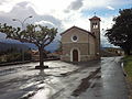
Church of Sainte-Thérèse de l'Enfant-Jésus
-2.JPG)
.JPG)