
Bärnau
| coat of arms | Germany map | |
|---|---|---|

|
Coordinates: 49 ° 49 ' N , 12 ° 26' E |
|
| Basic data | ||
| State : | Bavaria | |
| Administrative region : | Upper Palatinate | |
| County : | Tirschenreuth | |
| Height : | 615 m above sea level NHN | |
| Area : | 74.42 km 2 | |
| Residents: | 3105 (Dec. 31, 2019) | |
| Population density : | 42 inhabitants per km 2 | |
| Postal code : | 95671 | |
| Area code : | 09635 | |
| License plate : | TIR, KEM | |
| Community key : | 09 3 77 112 | |
| City structure: | 35 districts | |
City administration address : |
Marktplatz 1 95671 Bärnau |
|
| Website : | ||
| First Mayor : | Alfred Stier (CSU / JWG) | |
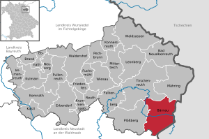
| Location of the town of Bärnau in the Tirschenreuth district | ||
  |
||

Bärnau is located in Tirschenreuth in Upper Palatinate , has since 1343 municipal rights and one of the oldest cities in Bavaria .


geography
Geographical location
The city, in northern Bavaria in the Upper Palatinate , near the border with the Czech Republic , has the neighboring towns of Obora (Thiergarten) and Halže (Hals) in Bohemia , to which the deserted Pavlův Studenec (Paulusbrunn) belongs, at which there is a border crossing. In Germany, Bärnau borders the municipalities of Mähring , Tirschenreuth and Plößberg in the Tirschenreuth district and the Flossenbürg municipality in the Neustadt an der Waldnaab district.
Community structure
It includes 35 districts:
history
Until the 19th century
Already at the time of the northern Gau Bärnau, at that time in the Egerland of the Staufer time , seat of a judge and the magistrate of the imperial city Eger ( Cheb ) was subject. In 1296 Baernau was at the monastery Waldsassen pledged, came in 1313 by buying the basic rule of the monastery and then served his income and commitments to Robot services, as many other towns and cities of the pin state , this then important monastery of the colonization period. In 1343, the Waldsassen monastery received from Emperor Ludwig IV (HRR) the right to develop the town of Bärnau as a town and to grant it town charter. A few years later, in 1351, the town of Bärnau came to the later Emperor Charles IV (HRR) , King of Bohemia and received the rights of the town of Tachau in Bohemia and other privileges under his feudal sovereignty . Bärnau, border town to the settlement area of Chodsko , located on an ancient trade route to Pilsen, was allowed to hold a weekly escort secured market day, an exclusion zone has been set and used a bailiff, who together with the mayor was in charge and the city council, the duties of a district court exercise . In the 14./15. The hammer Bärnau is mentioned in the 19th century .
In 1405 Bärnau came under the rule of the Wittelsbacher Electoral Palatinate . The town charter of Tachau was replaced by that of Amberg , the new administrative seat. In 1414 Bärnau was granted city rights for the fourth time , this time by Sulzbach . During the Thirty Years' War (1618–1648) and the re-catholicization , Bärnau belonged to the Electorate of Bavaria from 1628 and remained a Bavarian city on the border with Bohemia .
In 1627 Bärnau suffered badly from the plague like many other villages . Devastating city fires in 1622 and 1685 as well as the passage and taking up quarters of various troop units in the Thirty Years' War also made the population difficult. The Tilly-Schanze on the border with Bohemia , which is named after the general Johann t'Serclaes von Tilly , commemorates this war . According to tradition, the Czech reformer Jan Hus stopped on October 15, 1414, coming from Tachau on the way to the Council of Constance in Bärnau.
From the 16th to the 19th century there were glassworks south of Bärnau.
20th century
From February 14, 1945 to April 22, 1945 shortly before the end of the Second World War, there was a subcamp of the Flossenbürg concentration camp in Hohenthan , whose six prisoners had to do forced labor for the Kraus bakery.
Incorporations
On January 1, 1972, the previously independent communities of Ellenfeld and Thanhausen were incorporated. On May 1, 1978, areas of the dissolved communities of Hohenthan and Schwarzenbach were added.
Population development
Between 1988 and 2018, the population decreased from 3,661 to 3,153 by 508 or 13.9%.
politics
City council
Since the local elections on March 16, 2014, the local council has been composed as follows:
| Christian Social Union in Bavaria (CSU) | 5 seats |
| SPD Bavaria (SPD) | 3 seats |
| Young Voting Community (JWG) | 4 seats |
| Christian Free Voting Community (CFWG) | 4 seats |
coat of arms
Blazon: A black bear in silver standing on a green lawn with a four-piece shield on a red neck strap; therein 1 and 4 a red crowned and red armored golden lion in black, 2 and 3 the Bavarian diamonds.
Culture and sights

Museums
Buildings
- Silberhütte glassworks
- Thanhausen Castle
- Grenzlandturm
- Steinberg Church, baroque Wies Church for the Scourged Savior
- Cityscape with market square
- City parish church of St. Nicholas
- Baroque parish church of St. Bartholomew in Hohenthan
- Baroque parish church of St. Michael in Schwarzenbach
- Village chapel in Ellenfeld
- Bärnau-Tachov Historical Park
- Ellenfeld wind farm
- Village chapel in Hermannsreuth

nature
sport and freetime
- Thanhausen marching band
- City and youth brass band Grenzlandboum Bärnau
- Altglashütte forest outdoor pool
- Bärnau indoor swimming pool
- Football TSV Bärnau
- Soccer VfB Thanhausen
- Tennis court TC Bärnau
- Silberhütte cross-country skiing center
- Archery Club Bärnau
- Bowling KC Bärnau
Regular events
- historical market spectacle every two years
- German-Czech Festival
- annual bulldog meeting in the Thanhausen-Kaltenmühle district (third Sunday in July)
- Traditional village and oven festival on August 14th and 15th in Hermannsreuth
Economic development
Bärnau developed from a city of clothmakers and fabricators to an industrial city. At the beginning of the 20th century, button production based on the guild of cloth makers had settled. After 1945 and the expulsion and expropriation of the Germans in Tachov in Czechoslovakia , the mother-of-pearl industry settled there in Bärnau, 15 kilometers to the west. At the height of the economy in the 1950s, buttons in various sizes and shapes were made from mother-of-pearl in about 70 Bärnau button shops . In 1954, a municipal button school was established, and from 1967 to 1974 the international trade fair IKNOFA expanded the range of products for buyers of valuable buttons.
Since then, production has been switched to inexpensive buttons made of plastic ( thermoplastic , duroplastic ) and metal ( die-cast ) in order to be able to supply the newly created mass market inexpensively with rising labor costs. Due to a lack of reaction to changes in fashion demand and the competition from other production sites with a changed supply, the production of buttons in Bärnau came into a crisis. The number of button factories decreased and this continued until the beginning of the 21st century with business closures and bankruptcies . Since the beginning of the 21st century there has only been one employer who makes buttons.
traffic
Bärnau (Oberpf) was the terminus of the Wiesau – Bärnau railway line . This has now been shut down.
Personalities
- Ignatius von Senestrey (1818–1906), Bishop of Regensburg from 1858 to 1906, was born in Bärnau
- Karl Senestrey (1820–1901), Counselor in Munich, was born in Bärnau
- Ernst Kutzer (1918–2008), composer, grew up in Thanhausen and taught in Hohenthan
- Manfred Lindner (* 1957), physicist, was born in Ellenfeld
Web links
- Official city homepage
- Website Bärnau-Tachov History Park - experience the Middle Ages
- Entry on the coat of arms of Bärnau in the database of the House of Bavarian History
Individual evidence
- ↑ "Data 2" sheet, Statistical Report A1200C 202041 Population of the municipalities, districts and administrative districts 1st quarter 2020 (population based on the 2011 census) ( help ).
- ^ First Mayor Alfred Stier. Bärnau city administration, accessed on May 27, 2020 .
- ↑ http://www.bayerische-landesbibliothek-online.de/orte/ortssuche_action.html ? Anzeige=voll&modus=automat&tempus=+20111107/192107&attr=OBJ&val= 1075
- ^ Website of the Flossenbürg Concentration Camp Memorial Accessed July 6, 2016
- ^ Wilhelm Volkert (ed.): Handbook of Bavarian offices, communities and courts 1799–1980 . CH Beck, Munich 1983, ISBN 3-406-09669-7 , p. 580 .
- ^ Federal Statistical Office (ed.): Historical municipality directory for the Federal Republic of Germany. Name, border and key number changes in municipalities, counties and administrative districts from May 27, 1970 to December 31, 1982 . W. Kohlhammer GmbH, Stuttgart / Mainz 1983, ISBN 3-17-003263-1 , p. 663 .

Ahornberg | Altglashütte | Bärnau | Beard Mill | Beierfeld | Brechl | Bühlhaus | Ellenfeld | Gegelhof | Greim | Green | Hasenbühl | Heimhof | Hermannsreuth | Hohenthan | Wooden mill | Iglersreuth | Cold mill | Cellar mill (upper) | Cellar mill (lower) | Lip house | Mühllohe | Naab | Ödwaldhausen | Foreman | Schmuckerhof | Schwarzenbach | Silberhütte | Stöberlhof | Tännersreuth | Thanhausen | Turner mill | Turning | Zeimatshof | Brick hut

Bad Neualbenreuth | Bärnau | Fire | Ebnath | Erbendorf | Falkenberg | Friedenfels | Fuchsmühl | Immenreuth | Kastl | Kemnath | Konnersreuth | Krummennaab | Kulmain | Leonberg | Mähring | Mitterteich | Neusorg | Pechbrunn | Plößberg | Pullenreuth | Reuth near Erbendorf | Tirschenreuth | Waldershof | Waldsassen | Wiesau