
Ceuta
|
Ciudad Autónoma de Ceuta ( Spanish ) Ceuta |
|||||
|---|---|---|---|---|---|
|
|||||
 .svg) |
|||||
| Basic data | |||||
| Country : |
|
||||
| Area : | 18.5 km² | ||||
| Residents : | 84,777 (January 1, 2019) | ||||
| Population density : | 4,582.5 inhabitants / km² | ||||
| Expansion: | North – South: approx. 5 km West – East: approx. 8 km |
||||
| ISO 3166-2 : | ES-CE | ||||
| Website : | www.ceuta.es | ||||
| Politics and administration | |||||
| Autonomy since: | March 14, 1995 | ||||
| President : | Juan Jesús Vivas ( PP ) | ||||
| Representation in the Cortes Generales : |
Congress : 1 seats Senate : 2 seats |
||||
| map | |||||
 |
|||||


Ceuta ( pronunciation : [ ˈθeu̯ta ], Arabic سبتة, DMG Sabta ; Moroccan Tamazight ⵙⴰⴱⵜⴰ ) is a Spanish city on the North African coast and the Strait of Gibraltar with 84,777 inhabitants (as of January 1, 2019). As a Spanish exclave, Ceuta belongs to the European Union , but not to NATO , and has some special rights. In particular, it is excluded from the EU customs territory according to the Union Customs Code . Ceuta is also not part of the Schengen area .
Since the 15th century, Ceuta was first in Portuguese and later in Spanish possession; even after Morocco gained independence in 1956, Ceuta and Melilla, also located in North Africa, remained Spanish. From the Moroccan side, the territorial claim to the two cities is fundamentally emphasized, but concrete steps to enforce it have not been and will not be taken. Since 1995, Ceuta and Melilla have had the status of an “autonomous city” ( ciudad autónoma ), which gives them some of the powers of the autonomous communities . Ceuta has a border fence with Morocco to prevent immigration to the EU .
location

The 18.5 square kilometer Spanish exclave is located on the tip of a peninsula on the western Mediterranean coast of Morocco. The area has a land border with Morocco and is about 21 kilometers from the Iberian Peninsula . The ferry connection to Algeciras takes about an hour. The next larger city on Moroccan soil is Tétouan, about 40 kilometers south .
population
| year | 1877 1 | 1910 | 1940 | 1960 | 1970 | 1981 | 1991 | 2001 | 2011 | 2016 |
|---|---|---|---|---|---|---|---|---|---|---|
| Residents | approx. 10,500 | approx. 24,000 | approx. 59,000 | 73.182 | 67,187 | 70,864 | 73.208 | 75,694 | 82,376 | 84,519 |
In 2006, half of the population was Christian and the other half Muslim .
history

etymology
"Seven Brothers" was the ancient name of the Jbel Musa mountain range . From the place name “At the Seven Brothers”, the Roman loan translation Ad Septem Fratres resulted in the short form Septem → Septa . There is no / p / in Arabic, which is why it has been replaced by / b /: Arabic Sabta . For the umlaut / a / → / e / see Arabic dialects : Imāla .
The Portuguese and Spanish (and internationalized) form of the name is Ceuta . The substitution of the sound / b / (in Arabic Sabta ) by the sound / u / (in Ceuta ) corresponds to the frequent exchange of the graphemes “b” and “v / u” in the Iberoromanic languages .
Ancient and Middle Ages
The history of the city began with the Greeks - Phoenician traces have not yet been discovered. However, it is not certain whether permanent settlements existed on the site of today's Ceuta. The Greeks called the place Επτά Αδέλφια Heptá Adélphia , German 'Seven Brothers' , which refers to seven mountains in the area. In 319 BC The Carthaginians took over the city.
After the Second Punic War , Ceuta became Roman as Septem Fratres , and the residents were given Roman citizenship . Ceuta's strategic and economic importance grew and the city became - next to the competing Tingis (= Tangier ) - the most important of the Roman province of Mauretania Tingitana .
In 429 vandals conquered the city. In 534 it fell to the Byzantine Empire as the successor to the Roman Empire. In 616 it was conquered by the Visigoths . In 709 the Arabs and their allied Berber tribes finally took the city - two years before they came to the Iberian Peninsula to occupy it for centuries. In the following period Ceuta was under the Spanish Umayyads as well as the Berber Almoravids , Almohads and Merinids (briefly also the Tunisian Hafsids ).
Portugal and Spain (1415–1668)
On August 21, 1415, the troops of King John I conquered the city in a large-scale military operation as part of the Reconquista . For Portugal's ambitions to find the sea route to India , the location was strategically rather insignificant. In 1578 the young Portuguese King Sebastian I died in the battle of Alcácer-Quibir . In 1580 Ceuta fell to the Spanish crown by succession together with the motherland ( personal union ).
In 1640 Portugal declared itself independent again, which sparked a violent political dispute. After two military defeats in the War of Restoration , Spain recognized Portugal's independence in the Treaty of Lisbon (1668).
Spain (from 1668)
In 1668, Ceuta and Isla Perejil were ceded by Portugal to Spain under the Lisbon Peace Treaty. The city coat of arms of Ceuta has remained identical to the national coat of arms of Portugal to this day.
Today's borders were set in the Tétouan Peace Treaty in 1860 after the Spanish-Moroccan War . Therefore, in 1912, Ceuta did not become part of the Spanish protectorate in Morocco , but remained directly subordinate to the Spanish government as the Plaza de soberanía . Since the city was not part of the Protectorate, it remained part of Spain even after Moroccan independence (1956). Until March 14, 1995, Ceuta was part of the province of Cádiz . Since then it has been an "autonomous city" ( Ciudad autónoma ) and enjoys similar rights as the autonomous communities of the mother country. The latter also applies to Melilla .
In the course of the refugee crisis in Europe from 2015 onwards , Ceuta has increasingly come into the focus of international politics, as migrants from Africa have tried in large numbers to overcome the border fences around the city in order to obtain a right of residence in the European Union.
politics
Assembly
Twin cities
-
 Aci Catena , Italy
 -
 Algeciras , Spain
 -
Alhaurin de la Torre , Spain
-
Cadiz , Spain
-
 Guadalajara , Mexico
 -
Melilla , Spain
-
 Santarém , Portugal
Economy and Infrastructure
The most important industries in the primary sector are fish farming in aquaculture and fish processing - there is no agriculture in the area of the exclave. The construction sector also played an important role in the past , but population and economic growth has stagnated for several years, and with it the construction industry. From the free port , processed North Sea shrimps as well as fish and fruit are exported mainly in the area around Tétouan . Cross-border trade and financial transfers from mainland Spain or the rest of the EU are further economic pillars of the city. The only legal tender is the euro , but many shops also sell Moroccan dirhams , British pounds , US dollars and the like. assumed.
In comparison with the GDP of the EU, expressed in purchasing power standards, Ceuta achieved an index of 97 (EU-27: 100) (2006). In 2017 the unemployment rate was 22.4%, making it one of the highest in the European Union.
Until 1958, Ceuta had a rail link to Morocco with the Ceuta – Tétouan railway.
Culture and sights
The historic center of Ceuta has been recognized as a cultural asset ( Bien de Interés Cultural ) in the Conjunto histórico-artístico category .
Military buildings


- The oldest evidence of this type is the Merinid city wall from the 13th / 14th centuries in the west of the city. Century. It is built in the rammed earth construction typical of Morocco , which can withstand rifle bullets, but no longer offers any safety in the event of a fire with heavy artillery.
- Fortifications were certainly built after the Portuguese conquered the peninsula, but nothing has survived. The Foso de San Felipe dates from the 16th century, its two sloping end bastions ( baluartes ) were added in the 17th century. In addition to the fortifications on the island of Malta , the trench secured on the sides by high walls is one of the most powerful European military installations in the entire Mediterranean area.
- In the 17th century, smaller bastions were built all over the peninsula. The Fuerte de Aranguren comes from this time and is located on a hill west of the city.
- A similar building, the Fuerte de Ányera , is located in the rugged mountain landscape of Monte Hacho .
- The entire tip of the peninsula, with Monte Hacho at its highest point, is secured by a series of smaller forts. The former fortress El Desnarigado is secured with cannons against attacks from the sea. Today there is a military museum here .
Religious buildings

- The Cathedral of Santa María de la Asunción was founded in the 15th century on the foundations of a mosque , but has been expanded and rebuilt repeatedly in the following years. Its appearance today essentially corresponds to the half- baroque , half- neoclassical tastes of the 17th and 18th centuries; the last changes to the three-aisled interior were made in 1954/1955. It has been a bishopric since 1851 and forms a communal diocese with the Spanish city of Cádiz .
- The church of Santa María de África may be older than the cathedral; the last alterations were made in the 18th century. It houses a statue of the Virgin Mary of Nuestra Señora de África , who is venerated as the patron saint of the city.
- The Muley el Mehdi mosque was built in the middle of the 20th century and, with its square minaret, is based on the Almohad mosques in Morocco (see Koutoubia Mosque ).
Civil buildings

- The ones from the 12./13. Windowless Arab baths ( baños árabes ) dating back to the 19th century are lit exclusively by - sometimes star-shaped - skylights. The water necessary for the operation of the hammam was collected in cisterns ( aljibes ) with a capacity of several hundred cubic meters. Like the Roman thermal baths, the Islamic bathhouses were among the few vaulted buildings of the respective architectural tradition. The complex was built over in Christian times and only exposed again in the 1960s.
- The Monumento de los Heroes de África , built in neo-Gothic style , commemorates the soldiers who fell on the Spanish side during the Spanish-Moroccan War (1859-1860).
- Ceuta has several quite original residential buildings - the Casa de los Dragones or the Pret a Porter building, which was only built at the beginning of the new millennium, should be mentioned here.
Parks
- In the extensive green areas of the designed in the 1940s and 1950s, Parque de San Amaro also live Barbary apes .
- The Parque Marítimo del Mediterráneo was designed in the 1990s according to plans by the architect César Manrique .
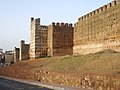
Merinidian city wall
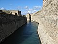
Foso de San Felipe

Military Museum El Desnarigado

One-man watchtower ( pepper box ) at the Baluarte Santa Ana

Muley el Mehdi mosque

Monument to the "Heroes of Africa" and cathedral (at night)

Casa de los Dragones

High-rise residential building Pret a Porter

.jpg)

.jpg)


Personalities
Sons and daughters of the town:
- al-Idrisi (1100–1166), cartographer, geographer and botanist
- Antonio Dorregaray (1820-1882), General
- Rafael Lesmes (1926–2012), football player
- Manuel Chaves (* 1945), politician
- José Martínez Sánchez "Pirri" (* 1945), football player
- Miguel Bernardo Bianquetti (* 1951), football player
- Nayim (born 1966), football player
- Carmen Miriam Jiménez Rivas (* 1982), member of the pop band Bellepop
- Guillermo Molina (* 1983), national water polo player ( World Champion 2001)
See also
Web links
- Official website of the City of Ceuta (Spanish)
- Ceuta, historical buildings - page not finished yet (Spanish)
- Leonie Wild: Blind Date with Europe: The Lidl refugees from Ceuta. Spiegel Online , December 17, 2007
- 1415 - Conquest of Ceuta on WDR 3 on August 21, 2015.
Individual evidence
- ↑ Cifras oficiales de población resultantes de la revisión del Padrón municipal a 1 de enero . Population statistics from the Instituto Nacional de Estadística (population update).
- ↑ Ceuta - translation into German - Langenscheidt dictionary Spanish-German. Retrieved August 3, 2018 .
- ↑ Art. 4, para. 1, indent 8 of Regulation (EU) No. 952/2013 of the European Parliament and of the Council of October 9, 2013 establishing the Union Customs Code (new version) . In: Official Journal of the European Union . L 269, October 9, 2013, p. 11.
- ^ JM Roa: Scholastic achievement and the diglossic situation in a sample of primary-school students in Ceuta . In: Revista Electrónica de Investigación Educativa . 8, No. 1, 2006.
- ^ FA Brockhaus Verlag Leipzig: General German Real Encyclopedia for the educated classes. 11th edition, Volume 4, page 291. Leipzig 1865 , accessed on August 20, 2011.
- ↑ see also: Siege of Ceuta (1419)
- ^ Kátia Brasilino Michelan: 'Ceuta: de terra dos mouros a base de um império' . In: Martin Malcolm Elbl (Ed.): Encounters in Borderlands: Portugal, Ceuta, and the 'other Shore' . Baywolf Press, 2019, ISBN 978-0-921437-56-7 , pp. 17-41.
- ↑ Thomas Urban , No longer welcome sz.de , August 24, 2018.
- ↑ Instituto Nacional de Estadistica ( Memento of September 24, 2015 in the Internet Archive ) (PDF).
- ↑ Unemployment rate, by NUTS 2 regions. Retrieved November 5, 2018 .
Autonomous Communities:
Andalusia |
Aragon |
Asturias |
Balearic Islands |
Basque Country |
Extremadura |
Galicia |
Canary Islands |
Cantabria |
Castile-La Mancha |
Castile and Leon |
Catalonia |
La Rioja |
Madrid |
Murcia |
Navarre |
Valencia

Member States of the United Nations
Egypt (also in Asia) |
Algeria |
Angola |
Equatorial Guinea |
Ethiopia |
Benin |
Botswana |
Burkina Faso |
Burundi |
Djibouti |
Ivory Coast |
Eritrea |
Eswatini | Gabon | Gambia | Ghana | Guinea | Guinea-Bissau | Cameroon | Cape Verde | Kenya | Comoros | Democratic Republic of the Congo | Republic of the Congo | Lesotho | Liberia | Libya | Madagascar | Malawi | Mali | Morocco | Mauritania | Mauritius | Mozambique | Namibia | Niger | Nigeria | Rwanda | Zambia | São Tomé and Príncipe | Senegal | Seychelles | Sierra Leone | Zimbabwe | Somalia | South Africa | Sudan | South Sudan | Tanzania | Togo | Chad | Tunisia | Uganda | Central African Republic
Dependent areas
Îles Éparses |
Canary Islands |
Madeira |
Mayotte |
Plazas de soberanía (with Ceuta and Melilla ) |
Réunion |
St. Helena, Ascension and Tristan da Cunha
Disputed Areas
Sahara Arab Democratic Republic |
Somaliland
Coordinates: 35 ° 53 ′ N , 5 ° 18 ′ W