
Sankt Peter im Sulmtal
|
Sankt Peter im Sulmtal
|
||
|---|---|---|
| coat of arms | Austria map | |
 |
|
|
| Basic data | ||
| Country: | Austria | |
| State : | Styria | |
| Political District : | Deutschlandsberg | |
| License plate : | DL | |
| Surface: | 10.98 km² | |
| Coordinates : | 46 ° 45 ′ N , 15 ° 15 ′ E | |
| Height : | 377 m above sea level A. | |
| Residents : | 1,256 (January 1, 2020) | |
| Postal code : | 8542 | |
| Area code : | 03467 | |
| Community code : | 6 03 29 | |
| NUTS region | AT225 | |
| Address of the municipal administration: |
Sankt Peter im Sulmtal 46 8542 Sankt Peter im Sulmtal |
|
| Website: | ||
| politics | ||
| Mayoress : | Maria Skazel ( ÖVP ) | |
|
Municipal Council : (2020) (15 members) |
||
| Location of Sankt Peter im Sulmtal in the Deutschlandsberg district | ||
  |
||
| Source: Municipal data from Statistics Austria | ||

Sankt Peter im Sulmtal is a municipality with 1256 inhabitants (as of January 1, 2020) in the Deutschlandsberg district in Styria .
geography
location
The municipality of Sankt Peter im Sulmtal is located in the Sulmtal in southern western Styria . The community is traversed by the Schwarzen Sulm , the Stullneggbach and the Leibenbach.
Community structure
The municipal area of Sankt Peter comprises six cadastral communities and is divided into a northern and a southern part by the Sulm. In the north, from east to west, are the cadastral communities of Wieden, Moos and Korbin. South of the Sulm from east to west are the cadastral communities of Kerschbaum, Sankt Peter im Sulmtal and Freidorf im Sulmtal (area as of December 31, 2019).
- Freidorf im Sulmtal (189.77 ha)
- Kerschbaum (212.92 ha)
- Korbin (122.07 ha)
- Moss (303.60 ha)
- St. Peter im Sulmtal (156.99 ha)
- Wieden (109.69 ha)
The community is divided into seven localities (population in brackets, as of January 1, 2020):
- Freidorf (97)
- Kerschbaum (147)
- Korbin (135)
- Moss (244)
- Poppenforst (78)
- Sankt Peter im Sulmtal (468)
- Wieden (87)
Neighboring communities
| Frauental | ||
| Bad Schwanberg |
.svg)
|
Sankt Martin im Sulmtal |
| Wies |
history
Archaeological excavations in Freidorf show a settlement from the Bronze Age.
Originally, the entire Sulmtal was owned by the Archdiocese of Salzburg . After 1225 the diocese Lavant , which was then newly founded from Salzburg, received property in this area. In 1228 “St. Peter iuxta Lindenberch “first mentioned in a document.
On June 24, 1645, the entire village fell victim to a fire.
The municipality was not affected by the Styrian municipal structural reform , which by 2015 reduced the number of municipalities in the Deutschlandsberg district from 40 to 15, nor were there plans to merge them with other municipalities.
population
Population structure
According to the 2001 census, the community had 1,267 inhabitants. 99.1% of the population had Austrian citizenship. 95.5% of the population professed to be part of the Roman Catholic Church, 2.4% were without religious beliefs.
Population development
The community's population growth was around 10% between 1869 and 1934, which can be attributed to the industrial settlements and coal mining of the time. During the 1930s and 1940s the population decreased to the original level. The population has been rising continuously since 1951, so that the population increased by around 50% between 1939 and 2005.
Culture and sights
- Parish church St. Peter im Sulmtal : With the campanile of St. Peter, the community has an architectural specialty. The 32 meter high, free-standing bell tower was built between 1662 and 1664. One of its bells is dated 1685. Possibly the building was intended as a tower for a church to be built later, but this was never realized in the adjacent area.
A parish church of St. Peter was first mentioned in 1244. After a fire in the previous church in 1645, today's church was completed between 1669 and 1701, consecrated to St. Peter and furnished with Rococo furnishings. Located in the church for templates of the Graz artist Erwin Huber created bronze door (based on one of the gates of St. Peter's Basilica in Rome) and a baptismal font , which was created also for templates of this artist.
- Since 1980 the community has also had a local history museum, which was set up in the former press building of the rectory (Kellerstöckl, around 1779). In this museum, the community presents the past and the activities of the associations, the parish and the community. Other topics are customs, the history of coal mining and significant events in the community.
- The community also has a nature trail .
- As part of the European Entente Florale Europe competition , Sankt Peter im Sulmtal was awarded a silver medal in the village category in 2000.
Economy and Infrastructure

According to the 2001 census of workplaces , there were 44 workplaces with 334 employees in the municipality as well as 397 out-commuters and 229 in-commuters. The most important industry is manufacturing. There were 86 agricultural and forestry holdings (22 of which were the main occupation), which together farmed 943 ha (1999).
Sankt Peter im Sulmtal is located on the Wieserbahn , which has been part of the Styrian rapid transit network since December 2007 (line S 6).
Together with St. Martin im Sulmtal and Bad Schwanberg, the community forms the “Sulmtal-Koralm” tourism association. Its seat is in Schwanberg.
politics
Municipal council
The local council of the municipality of Sankt Peter im Sulmtal is strongly dominated by the ÖVP . In the municipal council elections in 2015, she received 76.10% of the vote, which means a gain of 9.35% compared to 2010. The ÖVP was able to win an additional mandate.
The SPÖ landed in second place in 2015 with 14.22%, which means a gain of 1.16% compared to 2010 and they have two seats on the municipal council.
The list of names “SPM –St. Peter Mit Another “made it into the municipal council with 9.68% with one mandate.
- mayor
- 2003–2013 Alois Painsi (ÖVP)
- since 2013 Maria Skazel (ÖVP)
coat of arms
The municipal coat of arms was awarded by the Styrian regional government with effect from June 1, 1955.
Blazon :
- “A shield divided by silver over green. In the upper field a black rooster standing on the dividing line, in the lower field two crossed golden keys with beards turned up and out. "
Personalities
Honorary citizen
- 1998: Alois Korp, local council
- 2003: Karl Pommer (1940–2017), Mayor (1970–2003)
- 2005: August Plank, Vice Mayor
- 2009: Dorothea Fürnschuß, councilor
- 2012: Franz Ehgartner (* 1952), pastor
- 2013: Alfred Lohr, Med. Rat. Practical doctor
- 2014: Alois Painsi, Mayor (2003-2013)
- 2017: Anton Strametz, Vice Mayor (2003-2016)
People who lived in the community
- Hans Maria Fuchs (1874–1933), doctor and local researcher
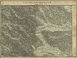
Historical maps
- Sankt Peter im Sulmtal and its surroundings from approx. 1789 to 1910
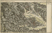
St. Peter in the Josephinische Landesaufnahme , around 1790
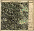
Franziszeische Landesaufnahme , approx. 1835

The north of St. Peter on the special map 1: 75,000, approx. 1910

The south of St. Peter in the recording sheet 1: 25,000 around 1878
St. Peter im Sulm-Thale, around 1878


literature
- August Krainer, Heide Kosjak: Chronicle of St. Peter in the Sulmtal. Peggau 1990
- Heimo Kaindl, Alois Ruhri: St. Peter in the Sulmtal. Parish Church of St. Peter. Diocese of Graz-Seckau, Styria. Salzburg 1994
Web links
- 60329 - Sankt Peter im Sulmtal. Community data, Statistics Austria .
- www.europadorf.at Website of the municipality of Sankt Peter im Sulmtal
Individual evidence
- ↑ This is how the 15 communities in Deutschlandsberg voted. meinviertel.at , June 29, 2020, accessed on August 18, 2020 .
- ↑ Local council election 2020 - results Sankt Peter im Sulmtal. orf.at , accessed on August 18, 2020 .
- ↑ Regionalinformation , bev.gv.at (1,094 kB); accessed on January 10, 2020.
- ↑ Statistics Austria: Population on January 1st, 2020 by locality (area status on January 1st, 2020) , ( CSV )
- ^ Find reports from Austria. Published by the Federal Monuments Office, Volume 45, year 2006, Vienna 2007, p. 60.
- ^ Styrian municipal structural reform .
- ↑ Kurt Woisetschläger, Peter Krenn: "Dehio Handbook - Austria's Art Monuments: Styria (excluding Graz)". Topographical inventory of monuments, ed. from the Federal Monuments Office, Department for Monument Research. Verlag Anton Schroll, Vienna 1982, ISBN 3-7031-0532-1 , p. 481.
- ↑ Flower Office Austria
- ↑ Grazer Zeitung , Official Gazette for Styria, December 30, 2014, 210th volume, 52nd issue, ZDB -ID 1291268-2 , p. 631.
- ↑ Elections. Retrieved January 28, 2020 .
- ↑ Thomas Stopper: Retired Mayor Alois Painsi is the new honorary citizen of St. Peter im Sulmtal. January 20, 2014, accessed December 23, 2019 .
- ↑ St. Peter im Sulmtal: parish council. Retrieved January 28, 2020 .
- ↑ Sankt Peter im Sulmtal: coat of arms. Retrieved January 28, 2020 .

Bad Schwanberg | Deutschlandsberg | Eibiswald | Frauental an der Laßnitz | Great Saint Florian | Lannach | Pölfing-Brunn | Preding | Sankt Josef (West Styria) | Sankt Martin im Sulmtal | Sankt Peter im Sulmtal | Sankt Stefan ob Stainz | Stainz | Wettmannstätten | Wies
93 Former communities (dissolved since 1945):
Aibl |
Aigen |
Bad Gams |
Blumegg |
Breitenbach in West Styria |
Dietmannsdorf im Sulmtal |
Ettendorf near Stainz |
Feisternitz |
Field tree |
Freidorf an der Laßnitz |
Open field near Deutschlandsberg |
Gamsgebirge |
Garanas |
Gasselsdorf |
Georgsberg |
Gersdorf |
Grafendorf near Stainz |
Graggerer |
Grass shoe |
Greisdorf |
Greith |
Gressenberg |
Großradl |
Grub near Groß Sankt Florian |
Grünau an der Laßnitz |
Gundersdorf |
Gussendorf |
Hasreith |
Herbersdorf |
Hollenegg |
Kleinradl |
Monastery |
Kornriegl |
Kothvogel |
Kraubath (West Styria) |
Krottendorf an der Laßnitz |
Kruckenberg |
Laaken |
Lasselsdorf |
Lebing |
Limberg near Wies |
Mainsdorf |
Marhof |
Mettersdorf |
Michlgleinz |
Nassau |
Neudorf near Stainz |
Neurath |
Niedergams |
Oberhart |
Upper Latin |
Oisnitz |
Osterwitz |
Otternitz |
Petzelsdorf in West Styria |
Pichling at Stainz |
Pirkhof |
Pitschgau |
Rassach |
Rossegg |
Rostock |
Red wine |
Sankt Oswald ob Eibiswald |
Sankt Ulrich in Greith |
Schönaich |
Sierling |
Soboth |
Stainztal |
Stable yard |
Stammeregg |
Sterglegg |
Sulmeck-Greith |
Sulz |
Sulz-Laufenegg |
Tanzelsdorf |
Teipl |
Tobis |
Tobisegg |
Trahütten |
Trough |
Unterbergla |
Vochera am Weinberg |
Vochera an der Laßnitz |
Front village |
Forest in West Styria |
Wernersdorf |
Wetzelsdorf in West Styria |
Wielfresen |
Wieselsdorf |
Torrent |
Wohlsdorf |
Zeierling |
Zirknitz