Sultanpur (district)
| Sultanpur District सुल्तानपुर जिला |
|
|---|---|

|
|
| State | Uttar Pradesh |
| Division : | Faizabad |
| Administrative headquarters : | Sultanpur |
| Area : | 4436 km² |
| Residents : | 3,797,117 * (2011) |
| Population density : | 856 * Ew./km² |
| Website : | sultanpur.nic.in |
| *) Figures refer to the Sultanpur district before the Amethi district split off in 2010. | |
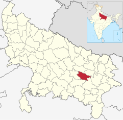
The district of Sultanpur ( Hindi : सुल्तानपुर जिला ) is a district of the Indian state of Uttar Pradesh . The administrative center is the eponymous city of Sultanpur .
geography
The Sultanpur district is located in the east of the Awadh (Oudh) region in central Uttar Pradesh and is part of the Faizabad division . Neighboring districts are Faizabad in the northwest, Ambedkar Nagar in the northeast, Azamgarh in the east, Jaunpur in the southeast, Pratapgarh in the southwest and Amethi in the west.
Before the Amethi district split off in 2010, the Sultanpur district had an area of 4436 km². The area belongs to the flat Ganges plain and is traversed by the Gomti , a tributary of the Ganges .
The Sultanpur District is divided into the four Tehsils Sultanpur, Kadipur, Lambhua and Jaisinghpur. The three Tehsils Amethi, Gauriganj and Musafir Khana came to the Amethi district in 2010.
history
The Sultanpur district was created by the British after they annexed the princely state of Oudh , to which the area had previously belonged, as a result of the Indian uprising of 1857 . In 1902 Oudh became part of the United Provinces , from which the state of Uttar Pradesh emerged after Indian independence in 1947. In 2010, the new Amethi District (originally called Chhatrapati Shahuji Maharaj Nagar ) was formed from parts of the Sultanpur and Raebareli districts .
population
According to the 2011 census, the Sultanpur district has 3,797,117 inhabitants according to the old territorial status (all the following information relates to the former district area including the areas that today belong to the Amethi district). Between 2001 and 2011 the population grew by 18 percent. The population density of 856 inhabitants per square kilometer is slightly above the already high average of the state (829 inhabitants per square kilometer). The district is very rural: only a little over five percent of the population live in cities. The urbanization rate is one of the lowest in Uttar Pradesh and is well below the state average (22 percent). At 69 percent, the literacy rate is close to the Uttar Pradesh average (68 percent).
According to the 2001 census , Hindus make up the majority of the residents of the district with 83 percent. There is also a Muslim minority of 16 percent.
Cities
The following list also includes those cities that have belonged to Amethi District since 2010:
| city | Population (2001) |
|---|---|
| Amethi | 12,808 |
| Chilkana Sultanpur | 16,110 |
| Dostpur | 11,877 |
| Kadipur | 6,795 |
| Koeripur | 7,268 |
| Korwa | 6,045 |
| Musafirkhana | 7,373 |
| Sultanpur | 100,085 |
Individual evidence
- ↑ Census of India 2011: Primary Census Abstract - Uttar Pradesh (PDF; 1.7 MB).
- ^ Census of India 2001: Basic Data Sheet. District Sultanpur (49), Uttar Pradesh (09). (PDF; 54 kB)
- ↑ Census of India 2001: Population, population in the age group 0-6 and literates by sex - Cities / Towns (in alphabetic order) ( Memento from June 16, 2004 in the Internet Archive )
literature
- Imperial Gazetteer of India. Volume 23: Singhbhūm to Trashi-Chöd-Zong. New edition, Clarendon Press, Oxford 1908, pp. 130-136 , keyword: Sultānpur District .
