
Bye
| Schüss / La Suze | ||
 The canalized Schüss, left the inlet of the Bielschüss |
||
| Data | ||
| Water code | CH : 274 | |
| location | Switzerland | |
| River system | Rhine | |
| Drain over | Zihl → Aare → Rhine → North Sea | |
| source | at the top of the Vallon de Saint-Imier , one of the long valleys of the folded Jura 47 ° 5 ′ 39 ″ N , 6 ° 52 ′ 12 ″ E |
|
| Source height | 965 m above sea level M. | |
| muzzle | in the Bielersee coordinates: 47 ° 7 ′ 55 " N , 7 ° 14 ′ 2" E ; CH1903: 584 467 / 220 135 47 ° 7 '55 " N , 7 ° 14' 2" O |
|
| Mouth height | 429 m above sea level M. | |
| Height difference | 536 m | |
| Bottom slope | 12 ‰ | |
| length | 43.4 km | |
| Catchment area | 216.27 km² | |
| Discharge at the Sonceboz A Eo gauge : 127 km² |
NNQ (1962) MNQ 1961–2016 MQ 1961–2016 Mq 1961–2016 MHQ 1961–2016 HHQ (1991) |
140 l / s 2.22 m³ / s 4.23 m³ / s 33.3 l / (s km²) 6.05 m³ / s 64.9 m³ / s |
| Drain at the mouth |
MQ |
6.15 m³ / s |
| Left tributaries | Le Terbez | |
| Right tributaries | L'Orvine | |
| Medium-sized cities | Biel | |
 Goodbye to La Heutte |
||
The Schüss ( French La Suze ) is a 43 km long river in the Bernese Jura .
geography
course
The source of the Schüss is above the hamlet of Le Cerf at the top of the Vallon de Saint-Imier , one of the long valleys of the Jura at 966 m above sea level. M. . The Schüss follows the valley in a northeasterly, later easterly direction to Reuchenette .

Here the Schüss breaks through in a classic Jurassic clus to the south. Shortly before entering the Plateau steps out, it forms the Taubenlochschlucht . The hiking trail through the gorge had to be closed several times because of the risk of falling rocks.
The Schüss then flows through Biel / Bienne , where its hydropower was used intensively in the age of industrialization. In Biel, the Schüss is divided into two natural and one artificially created arm. The southern arm - the Madretschschüss - flows directly into the Zihl , the northern arm - the Bielschüss - first crosses under the old town, then joins the artificially created Schüss Canal and finally flows out at an altitude of 429 m above sea level. M. in the Bielersee .
Catchment area
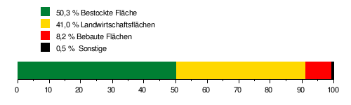
The catchment area of the Schüss is 216.27 km² and consists of 50.3% wooded area , 41.0% agricultural area and 8.2% settlement area .
The mean height of the catchment area is 984 m above sea level. M. , the minimum height is 427 m above sea level. M. and the maximum height at 1605 m above sea level. M.

| ||
Source and mouth of the Schüss
|
Tributaries
- L'Embossu ( right ), 0.4 miles
- Les Agettes ( left ), 0.2 km
- La Gentiane ( right ), 1.3 km
- Le Mont Suze ( right ), 1.5 km
- La Juillarde ( right ), 1.6 km
- Ruisseau du Château ( right ), 2.2 miles
- Sur le Pont ( right ), 0.4 km
- Fiolle ( right ), 0.3 km
- Les Planches ( right ), 0.8 km
- Le Bez ( right ), 3.2 km, 6.4 km²
- Moudon ( right ), 1.4 km
- La Doux ( left ), 0.5 km
- Le Torrent ( right ), 0.5 km
- Ruisseau les Bains ( right ), 0.7 km
- La Raissette ( left ), 0.2 km
- Le Pagrès ( right ), 0.8 km
- Les Ruaux ( right ), 1.0 km
- Aux Pailles neuves ( right )
- Crêt du Sapelot ( left )
- La Fenette ( right )
- L'Ergelie ( right )
- Le Rainson ( left )
- La petite fin ( left )
- Giélovas ( right )
- Petit Réservoir ( left )
- Le Grabe ( right )
- Les Queues ( left )
- Les Ruaux ( right )
- Peueraine ( right )
- Le Bez ( right )
- Les Planchers ( right )
- La Bottière ( right )
- La Bottière ( right )
- Ruisseau les Covos ( right )
- Ruisseau les Malés ( right )
- Tarreau de la Maure ( left )
- Ruisseau les Sarines ( right )
- Ruisseau de La Tscharner ( right )
- Canal ( right fork )
- Sources Les Bonnes Fontaines ( left )
- Les Golons ( left )
- Canal du Cerne ( right fork )
- Le Vernet ( left )
- Ruisseau des Poissonets ( right )
- Le Pichoux ( left )
- Le Terbez (left)
- Ruisseau Châtel 1 ( right )
- Ruisseau Horisberg ( right )
- Ruisseau Châtel 2 ( right )
- Ruisseau Châtel 3 ( right )
- L'Orvine ( right )
- Biel-Schüss ( right junction )
- Madretsch-Schüss ( right junction )
Hydrology
At the confluence of the Schüss in the Bielersee, the modeled mean flow rate (MQ) is 6.15 m³ / s. Her discharge regime type is pluvial jurassia, and her discharge variability is 26.
The flow rate of the Schüss fluctuates relatively strongly over the course of the year. The highest water levels were determined for the months of February to April. The flow rate peaked in April at 9.68 m³ / s. Thereafter, the discharge fell noticeably month after month and reached its lowest level in August at 3.30 m³ / s, only to increase steadily from month to month in September.
The modeled monthly mean discharge (MQ) of the Schüss in m³ / s

Web links
Individual evidence
- ↑ a b Geoserver of the Swiss Federal Administration ( information )
- ↑ Evaluations of the water network. (XLSX) FOEN , December 2013, accessed on August 9, 2017 (listing of Swiss rivers> 30km).
- ↑ a b c d Topographical catchment areas of Swiss waters: Suze
- ↑ Sonceboz measuring station 1961–2016 (PDF) Federal Office for the Environment FOEN
- ↑ "Hidden behind the mean values" - the variability of the discharge regime , p. 7
- ↑ The discharge variability describes the extent of the fluctuations in the mean discharge of individual years around the long-term mean discharge value.
Rivers with a total length of more than 30 km:
Aare |
Albula |
Allaine |
Old Rhine |
Arbogne |
Areuse |
Swiss stone pine |
Birs |
Brenno |
Broye |
Calancasca |
Doubs |
Drance de Bagnes |
Thinning |
Emme |
Engelberger Aa |
Ergolz |
Glâne |
Smooth |
Glenner (Glogn) |
Hinterrhein |
Inn (En) |
Julia (Gelgia) |
Kander |
Little Emme |
Landquart |
Land water |
Langete |
Limmat |
Linth |
Lorze |
Maggia |
Mentue |
Moësa |
Muota |
Murg |
Necker |
Orbe |
Petite Glâne |
Plessur |
Rabiusa |
Reuss |
Rhine |
Rhone |
Saane |
Schüss (Suze) |
Seez |
Scythe |
Sihl |
Simme |
Sitter |
Sorne |
Suhre |
Talent |
Tamina |
Ticino (Ticino) |
Thur |
Töss |
Venoge |
Verzasca |
Vispa |
Vorderrhein |
Wigger |
Wyna