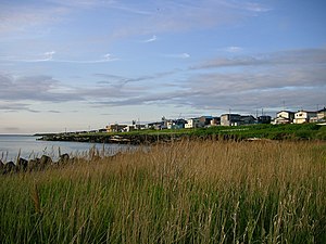
Teshio (Hokkaidō)
| Teshio-chō 天 塩 町 |
||
|---|---|---|
| Geographical location in Japan | ||
|
|
||
| Region : | Hokkaidō | |
| Prefecture : | Hokkaidō | |
| Coordinates : | 44 ° 53 ' N , 141 ° 45' E | |
| Basic data | ||
| Surface: | 353.31 km² | |
| Residents : | 3022 (September 30, 2019) |
|
| Population density : | 9 inhabitants per km² | |
| Community key : | 01487-7 | |
| Symbols | ||
| Flag / coat of arms: | ||
| Tree : | Prunus sargentii | |
| Flower : | Potato rose | |
| Bird : | Willow tit | |
| town hall | ||
| Address : |
Teshio Town Hall 8 - 1466 - 113 , Shinchidōri Teshio- chō , Teshio-gun Hokkaidō 098-3398 |
|
| Website URL: | http://www.teshiotown.hokkaido.jp/ | |
| Location Teshios in Hokkaidō Prefecture | ||
Teshio ( Japanese 天 塩 町 , - chō ) is a small town in Teshio County in the Rumoi sub-prefecture on Hokkaidō .
etymology
The name Teshio comes from Ainu teshu-o , which means " fish weir ".
geography
Teshio lies at the mouth of the eponymous river ( 塩 川 , -gawa ). Another body of water is the Kagami-numa ( 鏡 沼 , English "mirror pond").
history
In 1878 Teshio was appointed mura (village parish). April 1896 the town hall was built. On April 1, 1903 Shosambetsu was spun off as an independent village and on April 1, 1909 Horonobe . On April 1, 1915, it was appointed 2nd class community and April 1, 1924 1st class and Chō community .
Attractions
Teshio is home to the 38.9 ° C hot Teshio Onsen ( 天 塩 温泉 ).
The Teshio-gawa Historical Museum, housed in a red brick building, is home to the world's oldest fossil of a gray whale, at 3 million years old .
traffic
Teshio is the end of the national road 232, the other end of which is Rumoi . There is also a connection to National Road 40 to Asahikawa and Wakkanai . Prefecture streets that cross the town limits are prefecture streets 106, 256, 395, 484, 551, and 855.
All previous train connections to Teshio have been discontinued. The state JNR's Haboro line to Rumoi and Horonobe , which was completely closed in 1987 , stopped at Sarakishi Station, Kantaku Station, Teshio Station, Naka-Kawaguchi Station, Kita-Kawaguchi, Furaoi and Sakukaeshi Station. The Haboro line was originally used to transport coal.
economy
The main industries of Embetsu are fishing - especially mussels - and dairy farming.
education
In Teshio there are the primary schools Toshio, Sarakishi ( 更 岸 ) and Kitaubushi ( 北 産 Grund ), the middle school Teshio, the combined elementary and middle school Keitoku ( 啓 徳 ), and the high school Hokkaidō-Teshio.
There is also an experimental forest of the University of Hokkaidō in Teshio .
Town twinning
Teshio's sister city has been Homer in Alaska since April 1984 . Since July 1992 there has been a friendship between cities with the Russian Tomari . Until 1945 this belonged to Japan under the name Tomarioru.
Neighboring cities and communities
- Rumoi sub-prefecture:
- Soya Sub-Prefecture :
- Kamikawa Sub-Prefecture :
Individual evidence
- ↑ Ⅰ 概況. (No longer available online.) Rumoi Sub-Prefecture, p. 4 , archived from the original on August 13, 2016 ; Retrieved August 14, 2016 (Japanese). Info: The archive link was inserted automatically and has not yet been checked. Please check the original and archive link according to the instructions and then remove this notice.
- ↑ 天 塩 川 歴 史 資料 館. (No longer available online.) City of Teshio, archived from the original on August 22, 2016 ; Retrieved August 14, 2016 (Japanese). Info: The archive link was inserted automatically and has not yet been checked. Please check the original and archive link according to the instructions and then remove this notice.


