US Highway 54
| map | |
|---|---|

|
|
| Basic data | |
| Overall length: | 1197 mi / 1926 km |
| Opening: | 1926 |
| States: |
New Mexico Texas Oklahoma Kansas Missouri Illinois |
| Starting point: | on the Mexican border in El Paso |
| End point: |
|
| Important cities: |
Jefferson City Wichita Liberal Guymon Dalhart Tucumcari El Paso |
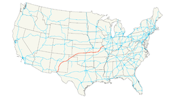
The US Highway 54 is a highway in the United States , the east-west direction about 1197 miles (1926 kilometers) from El Paso in the far west of Texas until after leading Illinois. It runs over two sections through the largest state of the contiguous states . The Union Pacific Railroad's El Paso to Wichita , Kansas railroad runs parallel to this highway for its entire length.
history
US Highway 54 was dedicated in 1926. Until 1972 the route continued east to Chicago . Today this section belongs to US Highway 36 , Illinois State Route 54, and US Highway 45 .
course
New Mexico
Coming from Texas, US 54 reaches New Mexico in Chaparral . In this area, the highway is of military importance as it connects Fort Bliss in El Paso with Holloman Air Force Base in Alamogordo . US 54 runs almost north through the middle of the state, via Tularosa to Carrizozo , where US Highway 380 intersects. From then on, the direction gradually changes to the northeast in an arc several hundred kilometers long. After another 130 km, US 54 reaches Vaughn with the intersections with US Highway 60 and US Highway 285 . About 65 km further cross the highway the Pecos River and reaches in Santa Rosa to Interstate 40 , US 54 to 95 km in length to Tucumcari replaced. The highway branches off to the northeast, crosses the Canadian River at Logan and returns to Texas at Nara Visa . The entire section of the route in New Mexico is two-lane.
Texas
After US 54 has its starting point on the border between the United States and Mexico in El Paso, the highway initially runs as a multi-lane freeway in a south-north direction along the eastern flank of the Franklin Mountains . After 23 miles (37 km) the highway crosses the state line to New Mexico, to later return to Texan territory 354 miles (around 570 km) after Nara Visa north of the Canadian River.
This second 95 mile (153 km) long section leads in a northeast direction through the Texas Panhandle and touches the places Dalhart - here intersect US Highway 87 and US Highway 385 - and Stratford , with the intersection of US Highway 287 .
Oklahoma
US 54 crosses the Oklahoma Panhandle in a northeast direction. The road enters Oklahoma near Texhoma , Texas and passes through Guymon and Hooker before crossing the Kansas border just before Liberal .
Kansas
US 54 reaches Kansas in Seward County and leads to Plains , where a common section with US Highway 160 begins and extends east of Meade . From there Route 54 runs northeast through Ford County . From Mullinville , the highway shares a significant stretch - 143 miles - with US Highway 400 .
The highway crosses as a two-lane road Greensburg , which was badly affected by a tornado in May 2007 , as well as Pratt , Cunningham and Kingman . In the east of Kingman County , where the outskirts of Wichita begin, the route is then developed like a motorway. Through Sedgwick County , it reaches the city limits of Wichita near Wichita Airport . Within Wichita, US 54/400 runs as Kellogg Avenue. Several highways intersect on this section, such as Interstate 235 , Interstate 135 , Interstate 35 ( Kansas Turnpike ) and finally Kansas State Route 96 .
The common course of US 54 and US 400 continues to Augusta in Butler County , where US 400 branches off eastwards towards the state border to Missouri , while US 54 from El Dorado forms a joint section with US Highway 77 . The route runs through the rural areas of Counties Greenwood and Wilson . After Fort Scott , US 77 swings north to Junction City and US 54 leaves Kansas east in Bourbon County to Missouri.
Missouri
Route 54 traverses Missouri diagonally from the southwest to the northeast corner. It is one of the main routes through the Ozarks and the main access road to Pomme de Terre Lake and the Lake of the Ozarks .
The route first touches Nevada , El Dorado Springs and Hermitage before crossing the Lake of the Ozarks north of Ha Ha Tonka State Park for the first time. It then passes through Camdenton and crosses the lake at the Grand Glaize Bridge at Osage Beach for the second time. Via Eldon , the Highway reaches Jefferson City , where the Missouri River is crossed on a joint section with US Highway 63 . Immediately after the Jefferson City Bridge , the 54 branches of Fulton off, then crosses in Kingdom City to Interstate 70 and eventually reaches about Mexico and Vandalia finally the Mississippi River in Louisiana and the state line to Illinois.
Illinois
In Illinois, the US runs from the Champ Clark Bridge over the Mississippi River to Interstate 72 near Griggsville. It's a rural two-lane road throughout. The length of Route 54 in Illinois is approximately 39 km.
Feeder
- former US Highway 154 between Dodge City and Mullinville
Web links
- US Highway Ends (English)


