
Stronghold-oh
|
Stronghold-oh
|
||
|---|---|---|
| coat of arms | Austria map | |
 |
|
|
| Basic data | ||
| Country: | Austria | |
| State : | Upper Austria | |
| Political District : | Braunau am Inn | |
| License plate : | BR | |
| Main town : | Hochburg | |
| Surface: | 40.09 km² | |
| Coordinates : | 48 ° 8 ' N , 12 ° 53' E | |
| Height : | 462 m above sea level A. | |
| Residents : | 3,264 (January 1, 2020) | |
| Population density : | 81 inhabitants per km² | |
| Postal code : | 5122 | |
| Area code : | 07727 | |
| Community code : | 4 04 14 | |
| NUTS region | AT311 | |
| Address of the municipal administration: |
Athaler Strasse 3 5122 Hochburg-Ach |
|
| Website: | ||
| politics | ||
| Mayor : | Johann Reschenhofer ( ÖVP ) | |
|
Municipal Council : (2015) (25 members) |
||
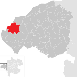
| Location of Hochburg-Ach in the Braunau am Inn district | ||
  |
||
| Source: Municipal data from Statistics Austria | ||

Hochburg-Ach is a municipality in Upper Austria in the Braunau am Inn district in the Innviertel with 3264 inhabitants (as of January 1, 2020). The responsible judicial district is the judicial district Mattighofen , until 2004 the municipality belonged to the judicial district Wildshut .
geography
Hochburg-Ach is located at an altitude of 462 m in the Innviertel directly opposite the Bavarian town of Burghausen . The extension is 8.8 km from north to south and 8.4 km from west to east. The total area is 40 km². 41.8% of the area is forested, 52.3% of the area is used for agriculture.
Community structure
The municipality includes the following 24 localities (population in brackets as of January 1, 2020):
|
|
The community consists of the cadastral communities Ach, Hochburg, Oberkriebach and Unterkriebach.
history
Hochburg-Ach is located in the area of the Günz / Mindel Ice Age terminal moraine of the Salzach Glacier, east of the Salzach , which has dug a river bed about 60 m deep there since the last Ice Age; to the west lies the Bavarian city of Burghausen . The Bavarian town of Hochburg belonged to the Duchy of Bavaria for a long time within the Holy Roman Empire . The Hallein salt played a major role in history. 500 to 600 boatmen were busy moving the salt downstream from March to October. On the way back they brought grain or wine into the country. After the Treaty of Teschen in 1779, the community came together with the Innviertel (then 'Innbaiern') to the Archduchy of Austria. During the Napoleonic Wars briefly returned to Bavaria, from 1814 the place belonged to Upper Austria in the Austrian Empire. After the fall of the Habsburg monarchy, the establishment of German Austria and the annexation of the Republic of Austria to the German Reich of the Hitler dictatorship on March 13, 1938, the place belonged to the "Gau Oberdonau"; after the Second World War and the fall of the empire to the re-established Republic of Austria.
The Sinti family Kerndlbacher lived in Hochburg-Ach until 1941 , of which only three family members survived their deportation to a concentration camp . (Ms. Rosa Winter-Kerndlbachers lived in Enns until 2005.) In 2004 the metal sculptor Peter Lechner erected a memorial on Erich Esterbauer's property to commemorate what happened at that time. On August 12, 2006, Gunter Demnig laid a so-called stumbling block for Johann Kerndlbacher . The laying is shown in the film Stolperstein by Dörte Franke .
Unterweitzberg
Unterweitzberg is a district with 87 inhabitants (as of 2001). It is a cleared area and extends on the western edge of the Weilhartforst , south-east of Hochburg. In old documents from 1287 the place name "Webersperch", the mountain of the weavers appears. Later then “Waizberg” and subsequently “Unterweitzberg”. House names refer to the trade “Webergorisölde” and the sparse soil, “Steinpointsölde”, “Ranshofersölde” from Middle High German rans , ran narrow, slight , arid.
On November 25, 1787 in Unterweitzberg 9 Franz Xaver Gruber , the composer of the Christmas carol Silent Night, Holy Night , was born. On the occasion of the joint state exhibition of Bavaria and Upper Austria, the Franz Xaver Gruber Community opened the Franz Xaver Gruber Friedensweg on June 3, 2012 , which is sponsored by several official bodies and private sponsors. The artist Hubert Flörl designed a series of sculptures for this.
Duttendorf
The town, which was already mentioned in a document in 1313, has 742 inhabitants (as of 2001). The place developed as a residential area after the Second World War. Numerous infrastructural facilities were created through further immigration; Among other things, the town hall of Hochburg-Ach is located here today.

Culture and tourism
Hochburg-Ach belongs to the Seelentium tourist region and is located opposite the Bavarian city of Burghausen with good views of its castle complex.
Are considered sights
- Franz Xaver Gruber Memorial House and Museum
- Peace path with sculptures by the artist Martin Flörl
- Parish church of the Assumption of Mary, two-aisled Gothic hall church , organ by Adam Heinrich Gruber
- Types of roses in the garden of Wanghausen Castle
- Themed gardens along the Salzach
The Tauern Cycle Path runs through Hochburg-Ach along the Salzach ; the place is also suitable for bike tours in and around the Weilhartsforst.
politics
On December 5, 2010, after the early resignation of Mayor Karl Lugmayr, the last mayoral elections took place, in which Johann Reschenhofer stood with 67.78% against the two other candidates Heinrich Taitl (20.56%) and Otto Wengler (11.67%) asserted.
coat of arms
Official description of the municipal coat of arms: In gold above a wavy, blue shield base a red, eight-pointed star. The municipality colors are yellow-blue.
Population development
In 1991 the community had 3,105 inhabitants according to the census, in 2001 it had 2,982 inhabitants.
Personalities

Sons and daughters of the church
- Martin Bichler , computer scientist at the Technical University of Munich
- Wolfgang Glechner , painter and writer
- Franz Xaver Gruber (1787–1863), composer
- Johann Kerndlbacher (1895–1942), victim of the Nazi regime
- Florian Schwanninger , political scientist and historian
People related to the community
- David Baum (* 1973), German journalist and author, grew up in Hochburg-Ach
- Stefan Esterbauer (* 1978), sculptor, lives and works in Hochburg-Ach
- Walter Ziegler (1859–1932), painter and graphic artist, often stayed at Wanghausen Castle from 1893, which he established as a meeting place for contemporary artists; died in Ach
literature
- Ludwig Laher (Ed.): It shouldn't have been us. Rosa Winter , Gitta and Nicole Martl. Three generations of Sinti women talk. Edition Geschichte der Heimat, 2004. ISBN 3-902427-10-8
- Hochburg-Ach community, life between Salzach and Weilhart, home in words and pictures , ISBN 3-902121-45-9
- Josef A. Standl , Silent Night Holy Night "the message of a song that touches the people of this world. Verlag" Documentation of Time ", 5110 Oberndorf. ISBN 3-901881-00-X
Individual evidence
- ↑ Statistics Austria: Population on January 1st, 2020 by locality (area status on January 1st, 2020) , ( CSV )
Web links
- Franz Xaver Gruber Community
- 40417 - Hochburg-Ach. Community data, Statistics Austria .
- Further information about the municipality of Hochburg-Ach on the geographic information system of the federal state of Upper Austria .
- Topothek Hochburg-Ach historical images, located, indexed and dated
- Silent night place Hochburg-Ach

Altheim | Aspach | Auerbach | Braunau am Inn | Burgkirchen | Eggelsberg | Feldkirchen | Franking | Geretsberg | Gilgenberg | Haigermoos | Handenberg | Helpfau-Uttendorf | Hochburg-Ach | Höhnhart | Jeging | Kirchberg | Lengau | Punch | Maria Schmolln | Mattighofen | Wall churches | Mining | Moosbach | Moosdorf | Munderfing | Neukirchen | Easter rental | Palting | Perwang | Pfaffstätt | Pischelsdorf | Polling | Rossbach | St. Georgen | St. Johann | St. Pantaleon | St. Peter | St. Radegund | St. Veit | Bowl | Schwand | Tarsdorf | Treubach | Oversize | Weng