
Valea Lunga (Alba)
|
Valea Lungă Langenthal Hosszúaszó |
|||||
|
|||||
| Basic data | |||||
|---|---|---|---|---|---|
| State : |
|
||||
| Historical region : | Transylvania | ||||
| Circle : | Alba | ||||
| Coordinates : | 46 ° 8 ' N , 24 ° 3' E | ||||
| Time zone : | EET ( UTC +2) | ||||
| Height : | 281 m | ||||
| Area : | 75.07 km² | ||||
| Residents : | 2,907 (October 20, 2011) | ||||
| Population density : | 39 inhabitants per km² | ||||
| Postal code : | 517815 | ||||
| Telephone code : | (+40) 02 58 | ||||
| License plate : | FROM | ||||
| Structure and administration (as of 2016) | |||||
| Community type : | local community | ||||
| Structure : | Valea Lungă, Făget , Glogoveț , Lodroman , Lunca , Tăuni | ||||
| Mayor : | Vasile Pușcă ( PNL ) | ||||
| Postal address : | St. Victoriei nr. 328 loc. Valea Lunga, jud. Alba, RO-517815 |
||||
| Website : | |||||


Valea Lungă [ ˈvalea lungɘ ] (outdated Hususău or Husăsău; German Langenthal , Hungarian Hosszúaszó ) is a Romanian municipality in the Alba district in the Transylvania region .
The place Valea Lungă is also known under the German name Langthal and Langendorf and the Hungarian Hosszúaszú .
Geographical location


The municipality of Valea Lungă is located in a hilly landscape in the south of the Kokel valley , in Transylvania. On the right bank of the lower reaches of the Târnava Mare (Great Kokel) - a left tributary of the Mureş - the community center is on the Teiuş – Braşov railway line and the Drum național 14B between Blaj (bubble village) and Copşa Mică (Kleinkopisch), Sibiu district . Valea Lungă is 19 kilometers southeast of Blaj; the district capital Alba Iulia (Karlsburg) is about 55 kilometers (36 km as the crow flies) to the west.
history
According to reports by K. Horedt , V. Pârvan and M. Roska, finds from the Bronze Age were made in the area of the incorporated village of Făget (birch village ) . In the village of Glogoveț (Tutendorf) there are - according to L. Köváry, N. Schroller and M. Roska - archaeological sites that indicate settlement in the Early Bronze Age .
The place Valea Lungă was first mentioned in 1309 under the name Longavallis . Located outside the historical Königsboden , Langenthal was a Transylvanian-Saxon serf village , ruled by Hungarian nobles in the Middle Ages . In 1848 there were 20 small noble families settled in the village. The family crypt of the Szentkereszthy family is located in the village's reformed cemetery .
The main occupations of the population are agriculture, wood processing and work in a gravel mine on the Mureș River.
population
The population of the municipality developed as follows: The population of the municipality of Vătava developed as follows:
| census | Ethnic composition | ||||
|---|---|---|---|---|---|
| year | population | Romanians | Hungary | German | other |
| 1850 | 4,307 | 2,907 | 182 | 692 | 526 |
| 1910 | 4,701 | 3,571 | 416 | 657 | 57 |
| 1941 | 5,299 | 4,075 | 182 | 794 | 248 |
| 1977 | 4,878 | 3,986 | 172 | 666 | 54 |
| 1992 | 3,506 | 3.116 | 126 | 109 | 155 |
| 2002 | 3,271 | 2,952 | 99 | 36 | 184 |
| 2011 | 2,907 | 2,634 | 66 | 15th | 192 |
The highest population (5,333) of today's municipality was determined in 1966. The highest population of Romanians (4,544) was registered in 1956, that of Germans in 1941, that of Hungarians in 1910 and that of Roma (243) in 1850. In addition, one resident referred to himself as a Serb in 1880, one each in 1900 and 1910, and four in 1930 as Slovaks .
In the village of Valea Lungă itself, 1901 people were registered in the 2002 census, of which 1661 were Romanians, 105 Roma, 99 Hungarians and 36 Germans.
Attractions
- The late Gothic towerless evangelical hall church , built in the 14th century, received a new coffered ceiling made of 118 fields in 1729 . The baroque altar and pulpit date from 1725; the stone baptismal font and the mascarons on consoles from the Middle Ages. Fragments of naive wall paintings have also been preserved in the church. The crypt under the choir of the church was set up as an ossuary ; from here an escape route led to a farm. On the ring-shaped, quarry stone, five-meter-high defensive wall of the church, two of the original six towers still stand. In 1981 the Transylvanian Saxons built a three-storey bell tower with a parapet made of rubble on the foundation of a collapsed defensive tower. The smaller of the two bells dates from 1592; the big one from 1710. The church is a listed building.
- In the village there is still the Roman Catholic and Greek Catholic Church , built around 1772, a Reformed Church donated by Baron Szentkereszti and an Orthodox Church , built in 1930. A synagogue , built at the end of the 19th century, was demolished after the Second World War .

Memorial stone of the Szentkereszthy family

Evangelical hall church ...
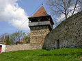
... and the bell tower
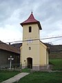
Greek Catholic Church

Roman Catholic Church
.JPG)
.JPG)

.JPG)
.JPG)
Personalities
- Vasile Aaron , (1770-1822) Romanian poet
- Friedrich Müller (also Friedrich Müller-Langenthal, 1884–1969), born in Langenthal, was bishop of the Evangelical Regional Church A. B. in Romania from 1945 until his death
- Josef Barth (1833–1915) was an important botanist in Transylvania; from 1864 to 1898 pastor in Langenthal.
Web links
- Website of Valea Lunga (Alba)
- Valea Lungă at ghidulprimariilor.ro
- Langenthal on sevenbuerger.de
- Web presentation of the Langenthal hometown community
Individual evidence
- ↑ 2011 census in Romania ( MS Excel ; 1.3 MB)
- ↑ Mayoral elections 2016 in Romania ( MS Excel ; 256 kB)
- ^ Dictionary of the localities in Transylvania
- ^ Institute Of Archeology - Făget und Glogoveț, accessed July 15, 2010 (Romanian)
- ↑ PRIMARIA COMUNEI VALEA LUNGA - Judetul Alba - PREZENTARE LOCALA - Istoric (Romanian)
- ↑ a b c d Heinz Heltmann, Gustav Servatius (Ed.): Travel Guide Siebenbürgen. Kraft-Verlag, Würzburg 1993, ISBN 3-8083-2019-2 .
- ↑ Census, last updated October 30, 2008, p. 183 (Hungarian; PDF; 1.2 MB)
- ↑ List of historical monuments of the Romanian Ministry of Culture, updated 2010 (PDF; 7.10 MB)
- ^ Konrad Gustav Gündisch: MÜLLER (-Langenthal), Friedrich (d. J.). In: Biographisch-Bibliographisches Kirchenlexikon (BBKL). Volume 6, Bautz, Herzberg 1993, ISBN 3-88309-044-1 , Sp. 239-242.
- ^ Josef Barth, in: Siebenbuerger.de Zeitung, November 12, 2008 .
- ↑ 100 years since the death of the Transylvanian botanist Josef Barth , in: Hermannstädter Zeitung, July 30, 2015.
Albac | Almașu Mare | Arieșeni | Avram Iancu | Berghin | Bistra | Blandiana | Bucerdea Grânoasă | Bucium | Câlnic | Cenade | Cergău | Ceru-Băcăinți | Cetatea de Baltă | Ciugud | Ciuruleasa | Crăciunelu de Jos | Cricău | Cut | Daia Română | Doștat | Fărău | Galda de Jos | Gârbova | Gârda de Sus | Hopârta | Horea | Ighiu | Întregalde | Jidvei | Livezile | Lopadea Nouă | Lunca Mureșului | Lupșa | Meteș | Mihalț | Mirăslău | Mogoș | Noșlac | Ocoliș | Ohaba | Pianu | Poiana Vadului | Ponor | Poșaga | Rădeşti | Râmeț | Rimetea | Roșia de Secaș | Roșia Montană | Sălciua | Săliştea | Sâncel | Sântimbru | Săsciori | Scărișoara | Șibot | Sohodol | Șona | Șpring | Stremț | Șugag | Unirea | Vadu Moților | Valea Lunga | Vidra | Vințu de Jos