
Vertheuil
|
Vertheuil Vertulh |
||
|---|---|---|
.svg)
|
|
|
| region | Nouvelle-Aquitaine | |
| Department | Gironde | |
| Arrondissement | Lesparre-Médoc | |
| Canton | Le Nord-Médoc | |
| Community association | Médoc Coeur de Presqu'île | |
| Coordinates | 45 ° 15 ′ N , 0 ° 50 ′ W | |
| height | 5-33 m | |
| surface | 21.94 km 2 | |
| Residents | 1,286 (January 1, 2017) | |
| Population density | 59 inhabitants / km 2 | |
| Post Code | 33180 | |
| INSEE code | 33545 | |
| Website | http://www.vertheuil-medoc.com/ | |
 Vertheuil Town Hall (Mairie) |
||

Vertheuil is a French commune in the department of Gironde in the region Nouvelle-Aquitaine with 1,286 inhabitants (as of January 1 2017). It belongs to the Arrondissement of Lesparre-Médoc and the canton of Le Nord-Médoc (until 2015: canton of Pauillac ). The inhabitants are called Vertheuillais .
geography
Vertheuil is located about 50 kilometers north-northwest of Bordeaux in the Médoc . Vertheuil is surrounded by the neighboring municipalities of Saint-Germain-d'Esteuil in the north and west, Saint-Seurin-de-Cadourne in the northeast, Saint-Estèphe in the east and Cissac-Médoc in the south.
population
| year | 1954 | 1962 | 1968 | 1975 | 1982 | 1990 | 1999 | 2006 | 2017 |
|---|---|---|---|---|---|---|---|---|---|
| Residents | 859 | 806 | 765 | 753 | 910 | 1,075 | 1,068 | 1,143 | 1,286 |
Attractions
- Benedictine monastery of Saint-Pierre from the 12th century, Monument historique since 1840
- Vertheuil Castle, Monument historique since 1965
- Beyzac Castle, Monument historique since 2006

Saint-Pierre monastery
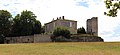
Vertheuil Castle

Beyzac Castle


Parish partnership
There is a partnership with the German municipality of Bevern in Lower Saxony.
Personalities
- Henri de Kérillis (1889–1959), journalist and politician
literature
- Le Patrimoine des Communes de la Gironde. Flohic Éditions, Volume 2, Paris 2001, ISBN 2-84234-125-2 , pp. 1034-1037.
Web links
Commons : Vertheuil - collection of images, videos and audio files