
Margaux-Cantenac
| Margaux-Cantenac | ||
|---|---|---|
|
||
| region | Nouvelle-Aquitaine | |
| Department | Gironde | |
| Arrondissement | Lesparre-Médoc | |
| Canton | Le Sud-Médoc | |
| Community association | Médoc Estuaire | |
| Coordinates | 45 ° 3 ′ N , 0 ° 41 ′ W | |
| height | 1–23 m | |
| surface | 21.62 km 2 | |
| Residents | 2,965 (January 1, 2017) | |
| Population density | 137 inhabitants / km 2 | |
| Post Code | 33460 | |
| INSEE code | 33268 | |

Margaux-Cantenac is a commune in the Gironde department in the region Nouvelle-Aquitaine with 2,965 inhabitants (as of January 1 2017). It belongs to the Arrondissement of Lesparre-Médoc and the canton of Le Sud-Médoc .
On January 1, 2017, Margaux-Cantenac was formed as a Commune nouvelle from the municipalities of Margaux and Cantenac .
geography
Margaux-Cantenac is located about 30 kilometers north-northwest of Bordeaux on the Gironde estuary . Margaux-Cantenac is surrounded by the neighboring communities of Soussans in the north and northwest, Gauriac in the northeast and Bayon-sur-Gironde in the east on the opposite side of the estuary, Labarde in the southeast, Arsac in the southwest and Avensan in the west.
The community belongs to the Margaux and Haut-Médoc wine-growing regions .
structure
| District | former INSEE code |
Area (km²) |
Altitude (m) |
Population (2016) |
Density (inh. Per km²) |
|---|---|---|---|---|---|
| Cantenac | 33091 | 14.26 | 1-22 | 1,371 | 96.1 |
| Margaux (administrative headquarters) | 33268 | 7.36 | 1-23 | 1,582 | 214.9 |
Attractions
See also: List of the Monuments historiques in Margaux-Cantenac
- Saint-Michel church in Margaux
- Saint Didier Church in Cantenac
- Wineries
- in Margaux:
- in Cantenac:
- Château Dauzac
- Château Cantemerle
- Château Palmer
- Château Cantenac-Brown
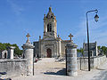
Saint-Michel church

Saint Didier Church


literature
- Le Patrimoine des Communes de la Gironde. Flohic Éditions, Volume 1, Paris 2001, ISBN 2-84234-125-2 , pp. 547-549.
Web links
Individual evidence
- ↑ Population figures retrospectively from January 1, 2016