
San Antonio: Difference between revisions
→Downtown: Fifty-five years in San Antonio, even living on the 'hispanic' side of town, downtown has never been refered to as "el centro" |
Add Boeing to companies with strong presence. |
||
| Line 162: | Line 162: | ||
[[Bank of America]] |
[[Bank of America]] |
||
[[Boeing]] |
|||
[[Caremark Rx Inc.]] |
[[Caremark Rx Inc.]] |
||
Revision as of 18:28, 30 July 2007
City of San Antonio | |
|---|---|
 | |
| Nickname(s): Alamo City; River City | |
 Location in the state of Texas | |
| Counties | Bexar County |
| Government | |
| • Mayor | Phil Hardberger |
| Elevation | 650 ft (200 m) |
| Population (2006) | |
| • City | 1,296,682 |
| • Metro | 1,942,217 |
| Time zone | UTC-6 (Central) |
| • Summer (DST) | UTC-5 (Central) |
| Website | www.sanantonio.gov |
San Antonio is the second-largest city in Texas and is the seventh most populous city in the United States. As of the 2006 U.S. Census estimate, the city had a population just under 1.3 million. As of 2006, the eight-county metropolitan area has a population of just under 2 million and is the 29th-largest metropolitan area in the USA. San Antonio, which is the county seat of Bexar County, covers over 400 square miles on the northern edge of the South Texas region of the State, and the southern edge of the Central Texas region. It has influences of both the American South and Southwest.
San Antonio was named for the Portuguese Saint Anthony of Padua, whose feast day it was (June 13) when a Spanish expedition stopped in the area in 1691. The city has a strong military presence—it is home to Fort Sam Houston, Lackland Air Force Base, Randolph Air Force Base, and Brooks City-Base, with Camp Bullis and Camp Stanley right outside the city. San Antonio is home to the South Texas Medical Center, the largest and only medical research and care provider in the South Texas region.
Famous for its River Walk, the Alamo, Tejano culture, and being home to SeaWorld and Six Flags Fiesta Texas theme parks, the city is visited by 20 million tourists per year. San Antonio is also home to the first museum of modern art in Texas—the Marion Koogler McNay Art Museum, as well as one of the most successful National Basketball Association teams in league history, the San Antonio Spurs.
History

American Indians originally lived along the San Antonio River in the San Pedro Springs area, calling the vicinity Yanaguana, meaning "refreshing waters."
In 1691, a group of Spanish explorers and missionaries came upon the river on June 13, the feast day of St. Anthony, hence naming the river after "San Antonio."
The actual founding of the city took place in 1718 by Father Antonio de San Buenaventura y Olivares, upon establishing Mission San Antonio de Valero. Hence via the efforts of Spanish soldiers and Canary Islanders, San Antonio de Béxar soon transformed into an early Spanish settlement in the Americas.
The Battle of the Alamo took place nearby in 1836, and eventually the town would grow to encompass the embattled mission. This was where 189 defenders held the old mission against some 4,000 Mexican troops led by Antonio López de Santa Anna for 13 days. The defenders were all killed. The cry "Remember the Alamo" became the rallying point of the Texas Revolution against Mexico.
Like many municipalities in the American Southwest, San Antonio experiences a steady population growth. The city's population has nearly doubled in 35 years, from just over 650,000 in the 1970 census to an estimated 1.2 million in 2005.
The city has also grown substantially in area. Unlike most large cities in the U.S., San Antonio is not completely surrounded by independent suburban cities and under Texas law exercises extraterritorial jurisdiction (ETJ) over much of the surrounding unincorporated land, including directing growth and zoning.[1] It pursues an aggressive annexation policy and opposes the creation of other municipalities within its ETJ.[2] Nearly three-fourths of its current land area has been annexed since 1960.[3] In recent years, the city has annexed several long narrow corridors along major thoroughfares to facilitate eventual annexation of growth developing along the routes. The city plans to annex nearly forty additional square miles by 2009.[4]
As of 2007, the Alamo is a shrine and museum located in the heart of downtown, and is surrounded by many hotels and tourist attractions. It is clearly San Antonio's most well-known landmark, and is featured in its flag and seal and in the city's nickname, "Alamo City". The Alamo is said to actually be haunted. Also, one hotel called the Crockett Hotel is said to be haunted by the ghost of Davy Crockett himself.
Geography
According to the United States Census Bureau, in 2000 the city had a total area of 412.07 square miles (1,067.3 km²) — 407.56 square miles (1,055.6 km²) of it is land and 4.51 square miles (11.7 km²) of it is water. The city sits on the Balcones Escarpment.
The primary source of drinking water for the city is the Edwards Aquifer. Impounded in 1962 and 1969, respectively, Victor Braunig Lake and Calaveras Lake were among the first reservoirs in the country built to use recycled treated wastewater for power plant cooling, reducing the amount of groundwater needed for electrical generation.
Cityscape
Downtown
Because of its status as a historic urban center, the architecture and layout of San Antonio are more traditionally urban than other cities in Texas, such as Dallas and Austin, which have developed in the last half century.
Downtown is encircled by three numerical freeways, Interstates 35 and 37, and U.S. Highway 90/Interstate 10. Together the three highways create a rectangular loop around the downtown area of San Antonio: I-35 to the north and west, I-37 to the east, and US-90/I-10 to the south.
Downtown is home to many districts including the Alamo District, Alamodome District, Central Business District, Convention Center District, Historic Civic District, Houston Street District, King William Historic District, La Villita District, Market Square District, North Downtown, North River District, River Bend District, SoSo (South of Southtown), Southtown, and the University District.
The Central Business District is home to Rivercenter, anchored by Dillard's and Macy's. The five-level Art Deco Dillard's, at the corner of Alamo and Commerce streets, opened in 1887 as Joske's. Joske's flagship store was 551,000 square feet in floor space until Dillard's bought the Joske's chain in 1987. Today, Dillard's only occupies a fraction of the original building.
Housing the famous Alamo many people can be seen traveling to visit the historic district. Attractions such as the river walk are home to many of the festivities throughout the year including NIOSA (Night In Old San Antonio) which celebrates fiesta, Cinco de mayo, and numerous parades such as celebrations for their home NBA team the Spurs, Christmas parades and much more.
-
 The River Walk at North St. Mary's St.
 -
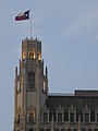 The Emily Morgan Hotel, one of the city's earliest highrises.
 -
 Houston Street.
 -
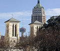 The San Fernando Cathedral, the Tower Life Building, and the Tower of the Americas.


Neighborhoods
Culture
Climate
San Antonio's weather is alternately dry or humid depending on prevailing winds, turning hot in the summer, mild to cool winters subject to descending northern cold fronts in the winter with cool nights, and comfortably warm and rainy in the spring and fall. Only a few freezes occur each year and snow is rare.
In San Antonio, July and August tie for the average warmest months with an average high of 95 degrees Fahrenheit (35°C). The highest temperature ever to be recorded was 111°F (43.8°C) on September 5, 2000.[5] The average coolest month is January. The lowest recorded temperature ever was 0°F (-17.7°C) on January 31, 1949. May, June, and October have quite a bit of precipitation. For the last 135 years, the average annual precipitation has been 29.05 inches (73.79 cm), with a maximum of 52.28 inches (132.79 cm) and a minimum of 10.11 inches (25.68 cm) in one year.[6]
| Climate data for San Antonio (San Antonio Int'l), 1991–2020 normals,[a] extremes 1885–present[b] | |||||||||||||
|---|---|---|---|---|---|---|---|---|---|---|---|---|---|
| Month | Jan | Feb | Mar | Apr | May | Jun | Jul | Aug | Sep | Oct | Nov | Dec | Year |
| Record high °F (°C) | 89 (32) |
100 (38) |
100 (38) |
101 (38) |
104 (40) |
108 (42) |
107 (42) |
110 (43) |
111 (44) |
99 (37) |
94 (34) |
90 (32) |
111 (44) |
| Mean maximum °F (°C) | 80.3 (26.8) |
84.9 (29.4) |
88.9 (31.6) |
92.2 (33.4) |
96.0 (35.6) |
98.9 (37.2) |
100.5 (38.1) |
102.1 (38.9) |
98.7 (37.1) |
93.1 (33.9) |
85.1 (29.5) |
80.6 (27.0) |
103.8 (39.9) |
| Mean daily maximum °F (°C) | 63.3 (17.4) |
67.5 (19.7) |
73.8 (23.2) |
80.3 (26.8) |
86.6 (30.3) |
92.4 (33.6) |
94.9 (34.9) |
96.0 (35.6) |
90.1 (32.3) |
82.2 (27.9) |
71.7 (22.1) |
64.7 (18.2) |
80.3 (26.8) |
| Daily mean °F (°C) | 52.2 (11.2) |
56.3 (13.5) |
62.8 (17.1) |
69.4 (20.8) |
76.5 (24.7) |
82.6 (28.1) |
84.8 (29.3) |
85.5 (29.7) |
79.9 (26.6) |
71.3 (21.8) |
60.7 (15.9) |
53.5 (11.9) |
69.6 (20.9) |
| Mean daily minimum °F (°C) | 41.0 (5.0) |
45.1 (7.3) |
51.8 (11.0) |
58.4 (14.7) |
66.4 (19.1) |
72.7 (22.6) |
74.7 (23.7) |
74.9 (23.8) |
69.6 (20.9) |
60.4 (15.8) |
49.8 (9.9) |
42.4 (5.8) |
58.9 (14.9) |
| Mean minimum °F (°C) | 26.2 (−3.2) |
29.0 (−1.7) |
33.7 (0.9) |
41.6 (5.3) |
53.1 (11.7) |
65.3 (18.5) |
70.2 (21.2) |
69.4 (20.8) |
57.4 (14.1) |
41.8 (5.4) |
32.2 (0.1) |
27.4 (−2.6) |
23.5 (−4.7) |
| Record low °F (°C) | 0 (−18) |
4 (−16) |
19 (−7) |
31 (−1) |
42 (6) |
48 (9) |
60 (16) |
57 (14) |
41 (5) |
27 (−3) |
21 (−6) |
6 (−14) |
0 (−18) |
| Average precipitation inches (mm) | 1.96 (50) |
1.74 (44) |
2.31 (59) |
2.42 (61) |
4.40 (112) |
3.28 (83) |
2.41 (61) |
2.15 (55) |
3.88 (99) |
3.75 (95) |
2.08 (53) |
2.00 (51) |
32.38 (822) |
| Average snowfall inches (cm) | 0.0 (0.0) |
0.1 (0.25) |
0.0 (0.0) |
0.0 (0.0) |
0.0 (0.0) |
0.0 (0.0) |
0.0 (0.0) |
0.0 (0.0) |
0.0 (0.0) |
0.0 (0.0) |
0.0 (0.0) |
0.1 (0.25) |
0.2 (0.51) |
| Average precipitation days (≥ 0.01 in) | 6.9 | 7.4 | 8.5 | 6.4 | 8.3 | 7.0 | 5.0 | 4.7 | 6.9 | 6.4 | 6.4 | 7.4 | 81.3 |
| Average snowy days (≥ 0.1 in) | 0.0 | 0.3 | 0.0 | 0.0 | 0.0 | 0.0 | 0.0 | 0.0 | 0.0 | 0.0 | 0.0 | 0.0 | 0.3 |
| Average relative humidity (%) | 67.1 | 65.2 | 63.2 | 66.3 | 70.5 | 68.8 | 65.0 | 64.7 | 68.0 | 67.2 | 68.3 | 68.0 | 66.9 |
| Average dew point °F (°C) | 37.0 (2.8) |
39.9 (4.4) |
46.8 (8.2) |
55.6 (13.1) |
63.7 (17.6) |
68.4 (20.2) |
68.9 (20.5) |
68.5 (20.3) |
65.7 (18.7) |
57.0 (13.9) |
48.0 (8.9) |
40.1 (4.5) |
55.0 (12.8) |
| Mean monthly sunshine hours | 159.4 | 169.7 | 215.5 | 209.7 | 221.8 | 275.9 | 308.8 | 293.9 | 234.9 | 218.0 | 171.9 | 149.7 | 2,629.2 |
| Percent possible sunshine | 49 | 54 | 58 | 54 | 52 | 66 | 72 | 72 | 63 | 61 | 54 | 47 | 59 |
| Source: NOAA (relative humidity, dew point and sun 1961–1990)[7][8][9] | |||||||||||||
Demographics
According to the 2000 U.S. Census, the city had a population of 1,144,646,[10] ranking it the seventh-most populated city in the country. Due to San Antonio's low density rate and lack of significant population surrounding the city limits, the metropolitan area ranked 30th in the U.S. with a population of 1,592,383.[11]
Subsequent population estimates have shown San Antonio continued its growth. The July 1, 2005, population estimate for the city was 1,256,509,[12] making it the second-most populated city in Texas and the seventh-most populated city in the U.S. The 2005 U.S. Census estimate for the eight-county (Atascosa, Bandera, Bexar, Comal, Guadalupe, Kendall, Medina, and Wilson Counties) San Antonio metropolitan statistical area (MSA) placed its population at 1,992,383,[13] making it the third-most populated metro area in Texas and the 29th-most populated metro area in the U.S.
There are 405,474 households, and 280,993 families residing in the city. The population density is 2,808.5 people per square mile (1,084.4 km²).
There are 433,122 housing units at an average density of 1,062.7 per square mile (410.3 km²). According to U.S. Census data from 2005, the racial make up of San Antonio is 67.7% White, 6.8% African American, 1.6% Asian, 0.8% Native American, and 3.7% from two or more races. 67.7% of the population is of Hispanic origin and could be of any race.[14]
Government integration of the military bases after World War II ended in 1945 spread peacefully into the schools and other facilities.[15]
In the city the population is spread out with 28.5% under the age of 18, 10.8% from 18 to 24, 30.8% from 25 to 44, 19.4% from 45 to 64, and 10.4% who are 65 years of age or older. The median age is 32 years. In San Antonio, 48% of the population are males, and 52% of the population are females. For every 100 females there are 93.5 males. For every 100 females age 18 and over, there are 89.7 males.
The median income for a household in the city is $36,214, and the median income for a family is $53,100. Males have a median income of $30,061 versus $24,444 for females. The per capita income for the city is $17,487. 17.3% of the population and 14.0% of families are below the poverty line. Out of the total population, 24.3% of those under the age of 18 and 13.5% of those 65 and older are living below the poverty line.
Economy
San Antonio has a diversified economy with four primary focuses: financial services, health care, national defense, and tourism. Located northwest of the city center is the South Texas Medical Center, the largest medical research and care provider in South Texas, which is a conglomerate of numerous major hospitals, clinics, and research and higher educational institutions. The center is "chief catalyst" for a $14 billion biomedical industry.[16] It employs over 27,000 persons with a combined total budget of $2.8 billion.[17] San Antonio is the only city in the United States hosting three Level I Trauma Centers within the city limits (2 military, 1 civilian).
The city is also home to one of the largest military concentrations in the United States. Fort Sam Houston on the city's northeast side hosts Brooke Army Medical Center, focus of the U.S. Army's medical command and training functions. Lackland Air Force Base on the city's west side is one of the world's largest training complexes. While it is known for hosting the U.S. Air Force's basic military training, it also hosts follow-on technical training for many other Air Force specialties, as well as other operations. Randolph Air Force Base on the far northeastern outskirts is the headquarters of the Air Education and Training Command, headquarters for Air Force personnel management and also hosts pilot training. Additionally, Brooks City-Base on the city's south side and KellyUSA adjoining Lackland still have significant military presences as well as defense contractor businesses. The defense industry in San Antonio employs over 89,000 and provides a $5.2 billion impact to the city's economy.[18]
Twenty million tourists visit the city and its attractions every year, contributing substantially to the city's economy.[19] The San Antonio Convention Center alone hosts more than 300 events each year with over 750,000 convention delegates from around the world.
San Antonio's corporate profile includes:
AT&T (formerly SBC)
Toyota Motor Manufacturing Texas
and
which are all headquartered in the city. Companies not headquartered in San Antonio but which have a strong presence in the city include
and in the future, Microsoft.[21] Other industries are establishing plants in the area, as the city's economy continues to grow.
- See also: List of foreign consulates in San Antonio.
Attractions
San Antonio is a popular tourist destination. The jewel of the city is the River Walk, which meanders through the downtown area. Lined with numerous shops, bars, restaurants, as well as the Arneson River Theater, this attraction is transformed into an impressive festival of lights during the Christmas and New Year holiday period, and is suffused with the local sounds of folklorico and flamenco during summers, such as the Fiesta Noche del Rio. Also based on the River Walk is the newly restored Aztec On The River, the only surviving exotic-themed movie palace in Texas. The Alamo is Texas' top tourist attraction, while the River Walk is the second most visited attraction.
The downtown area also features HemisFair Park (home of the Tower of the Americas and the Institute of Texan Cultures), La Villita, El Mercado, the Spanish Governor's Palace, the Alamo and the historic Menger Hotel. On the northern side of the Alamo complex, beside the Emily Morgan Hotel, is the San Antonio Cavalry Museum, which features cavalry artifacts and exhibits and is frequented by local re-enactors.
The Fairmont Hotel, built in 1906, is in the Guinness Book of World Records as one of the heaviest buildings ever moved intact. It was placed in its new location, three blocks south of the Alamo, over four days in 1985, and cost $650,000 to move. The Fairmont houses the "Sage Ristorante e Bar."
-
 The Alamo, San Antonio's most famous attraction
 -
The holiday season on the River Walk
-
The Torch of Friendship sculpture
-
 San Antonio's historic River Walk extends some 2½ miles, attracting several million visitors every year.
 -
 Another view of the city's vibrant downtown
 -
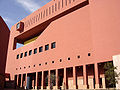 Central Library of The San Antonio Public Library
 -
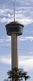 The Tower of the Americas characterizes the city's skyline
 -
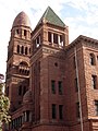 The historic Bexar County Courthouse
 -

-
-


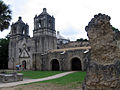
Other places of interest include the San Antonio Zoo, Japanese Tea Gardens, Brackenridge Park, the missions of the San Antonio Missions National Historical Park, the Witte Museum, the McNay Art Museum, SeaWorld San Antonio, Six Flags Fiesta Texas, and Splashtown San Antonio. Visitors can also experience something of the cowboy culture year round, they can see the 40-foot (12 m) tall cowboy boots at North Star Mall.
Beyond taking in the sights and sounds of San Antonio, tourists can sample some of its world famous Tex-Mex cuisine at the many fine restaurants located throughout the city. San Antonio is (to residents, former residents, and many visitors) the undisputed home of authentic Tex-Mex. Mexican restaurants are abundant in virtually all parts of town, and most — except for those in the Far North and some of the Uptown enclaves like Alamo Heights — are relatively inexpensive. Jacala Restaurant on West Avenue, Los Barrios on Blanco Road, and Karam's and Salsa Mora Restaurant on the West Side are just a few examples of the outstanding Tex-Mex eateries San Antonio offers. San Antonio also has establishments offering Texas style barbecue, and for the truly intrepid barbecue aficionado, a day trip to some of the more renowned barbecue pits and smokehouses of South Texas is both necessary and easily manageable.
Sports
The city's only top-level professional sports team, and consequently the team most San Antonians follow, is the San Antonio Spurs of the National Basketball Association. The Spurs have been playing in San Antonio since 1973 and have won four NBA Championships (1999, 2003, 2005, and 2007). Previously, the Spurs played at the Alamodome, which was built for football, and before that the HemisFair Arena, but the Spurs built and moved into the SBC Center in 2002, since renamed the AT&T Center, following the merger of giants SBC and AT&T.
The AT&T Center is also home to the San Antonio Rampage of the American Hockey League and the San Antonio Silver Stars of the WNBA, both owned by the Spurs. San Antonio is also home to the Double-A Minor League affiliate of the San Diego Padres, the San Antonio Missions who play at Nelson Wolff Stadium on the west side of the city. San Antonio also hosts the NCAA football Alamo Bowl each December. In 2007, San Antonio will be the home of the San Antonio Steers, a minor league football team of the National Indoor Football League. The Steers will play at the San Antonio Rose Palace in Boerne. San Antonio also has a rugby team, the Alamo City Rugby Football Club, a minor team in third division league of the Texas Rugby Union.
The city was also a temporary home for the New Orleans Saints for the 2005 NFL season due to the effects of Hurricane Katrina. The Saints set up practice facilities in San Antonio for the season, and played a split home schedule between the Alamodome and Baton Rouge, Louisiana's Tiger Stadium during the 2005 season. After the final game in San Antonio, the Saints committed to moving back to New Orleans for the 2006 season. City officials are said to be attempting to lure the National Football League permanently to San Antonio and have also said that a strong showing at the Alamodome for the three local Saints games was vital to showing that San Antonio can support an NFL franchise. NFL Commissioner Paul Tagliabue stated San Antonio was successful in hosting the team, and that the city would be on the short list for any future NFL expansions. The city has also hosted the Dallas Cowboys and Houston Oilers preseason camps in the past, and they have signed a contract with the Cowboys in which the Cowboys will practice in San Antonio through 2011.[22] Cowboys owner Jerry Jones has acknowledged his support for the city's efforts to become home to an NFL franchise.[23] Despite this, San Antonio remains the largest metropolis in the United States with neither an NFL franchise nor a Division I college football team.
In March 2006, the city also made an offer to build a stadium for the struggling Florida Marlins baseball franchise. However, the Marlins and Major League Baseball, while indicating San Antonio would be a viable relocation option if things did not work out in Florida, have declined the offer and appear to be focused on keeping the franchise in South Florida.
Some current names in professional sports from the city of San Antonio's high school sports programs include Dallas Cowboys wide receiver Sam Hurd, New Orleans Hornets guard Devin Brown, Minnesota Vikings 2006 second-round draft pick Cedric Griffin, Kansas City Chiefs running back Priest Holmes, Houston Texans defensive end N.D. Kalu, Florida Marlins pitcher Logan Kensing, WWE Superstar Shawn Michaels, Miami Heat center Shaquille O'Neal, and Olympic gold medalist Darold Williamson.
Government
The City of San Antonio runs under a Council-Manager form of government. The city is divided into 10 council districts designed to ensure equal population distribution between all districts. Each district elects one person to sit on the City Council with the mayor elected on a city-wide basis. All members of the City Council, which includes the mayor, are elected to two-year terms and are limited to two total terms. All positions are elected on non-partisan ballots as required by Texas law. Council members are paid $20 a meeting, while the Mayor earns $4,000 a year. Most council members maintain full-time employment in addition to their positions on the council.
The council hires the City Manager to handle day to day operations. The council effectively functions as the city's legislative body with the City Manager acting as its Chief Executive, responsible for the management of day to day operations and execution of council legislation.
The current mayor is Phil Hardberger (an active supporter of the U.S. Democratic Party, but officially elected on a non-partisan basis). Before he took office as San Antonio's mayor, he served as Chief Justice on the Fourth Court of Appeals of Texas. The current City Manager is Sheryl Sculley.
The city stretches into several national congressional districts and is represented in Congress by the following:[24]
- Senate
- House of Representatives
- Texas District 20 - Charlie Gonzalez (D)
- Texas District 21 - Lamar Smith (R)
- Texas District 23 - Ciro Rodriguez (D)
- Texas District 28 - Henry Cuellar (D)
Growth policy
Unlike most large cities in the U.S., San Antonio is not completely surrounded by independent suburban cities and under Texas law it exercises extraterritorial jurisdiction (ETJ) over much of the surrounding unincorporated land, including directing growth and zoning.[25] It pursues an aggressive annexation policy and opposes the creation of other municipalities within its ETJ.[26] Nearly three-fourths of its current land area has been annexed since 1960.[27] In recent years, the city has annexed several long narrow corridors along major thoroughfares in outlying areas to facilitate eventual annexation of growth developing along the routes. The city plans to annex nearly forty additional square miles by 2009.[28]
Involuntary annexation is a controversial issue in those parts of unincorporated Bexar County affected by it. Residents, attracted to the outlying areas by lower taxes and affordable real estate values, often see annexation as a mechanism to increase property tax rates without a corresponding improvement in services such as police and fire protection, while the city regards its annexation policy as essential to its overall prosperity.[29]
Education
Colleges, universities, and research institutes
San Antonio hosts over 100,000 students across its 31 higher-education facilities which include:


- Alamo Community College District
- Northeast Lakeview College
- Northwest Vista College
- Palo Alto College
- San Antonio College
- St. Philip's College
- Baptist University of the Américas
- Cancer Therapy and Research Center
- Everest Institute
- Hallmark Institure of Aeronautics
- Hallmark Institute Of Technology
- ITT Technical Institute
- Mind Science Foundation
- Oblate School of Theology
- Our Lady of the Lake University
- Southwest Foundation for Biomedical Research
- Southwest Research Institute
- St. Mary's University
- St. Mary's University School of Law
- Texas A&M University–Kingsville System Center (which will become Texas A&M University–San Antonio in 2009)
- Trinity University
- The University of Texas at San Antonio
- The University of Texas Health Science Center at San Antonio
- University of Phoenix - San Antonio
- University of the Incarnate Word
- Wayland Baptist University
Public schools and libraries
San Antonio and Bexar County are served by 15 separate independent school districts:
- Alamo Heights ISD
- East Central ISD
- Edgewood ISD
- Fort Sam Houston ISD
- Harlandale ISD
- Judson ISD
- Lackland ISD
- North East ISD
- Northside ISD
- Randolph Field ISD
- San Antonio ISD
- Schertz-Cibolo-Universal City ISD
- South San Antonio ISD
- Southside ISD
- Southwest ISD
The city is served by the San Antonio Public Library.
Private schools
San Antonio has many private schools, including:
- Antonian College Preparatory High School (the largest Catholic high school in San Antonio)
- Central Catholic Marianist High School (the oldest all-boy's school in Texas)
- Christian Academy of San Antonio (CASA)
- The Circle School, non-sectarian, non-profit co-op private school (pre k–3rd)
- Cornerstone Christian School (operated by Cornerstone Church, who's pastor is well-known televangelist John Hagee)
- Destiny Christian Schools
- Gateway Christian School
- Harvest Academy
- Holy Cross High School
- Incarnate Word High School
- Keystone School, non-sectarian
- Eleanor Kolitz Academy
- Lutheran High School of San Antonio
- New Life Christian Academy
- Providence High School
- Rainbow Hills Baptist School
- Saint Mary's Hall
- Saint Pius X Catholic School
- San Antonio Academy
- San Antonio Christian Schools
- St. Anthony Catholic High School
- St. Matthew Catholic School
- St. Paul Catholic School
- St. Gerard Catholic High School (the city's first co-educational high school)
- St. Luke Catholic School
- T.M.I.: The Episcopal School of Texas
- The Winston School Of San Antonio (A school for children with dyslexia, ADD and ADHD)
- Village Parkway Christian School, [3]
Transportation

The San Antonio International Airport is located in north central San Antonio, approximately eight miles from downtown. It has two terminals and is served by 15 airlines serving 35 destinations including two in Mexico. An extensive bus and trolley system (vehicular not rail) is provided by the city's metropolitan transit system, VIA Metropolitan Transit. VIA offers 78 regular bus routes and four trolley routes, including express routes from downtown to the theme parks. VIA also offers a special service to city events, including Spurs games and city parades, from its Park and Ride locations. [30]
Amtrak, the national passenger rail service, provides service to San Antonio at San Antonio Amtrak Station, operating its Texas Eagle daily between San Antonio and Chicago's Union Station.[31] Amtrak also operates its Sunset Limited three times a week in each direction through San Antonio between Los Angeles and Orlando, Florida (currently truncated to New Orleans due to the effects of Hurricane Katrina).[32] The Texas Eagle section travels between San Antonio and Los Angeles as part of the Sunset Limited. The old Sunset Station is now an entertainment venue owned by VIA and neighbored by the current station and the Alamodome.[33]
Transportation by bicycle is safe on some roads, not as safe on some other roads. In general San Antonio may not be as bicycle friendly or acclimated to it as a form of transport as some coastal US cities. There are designated bicycle lanes on a percentage of the city roads such as historical districts, missions trails, university paths and surrounding areas. Many independent organized groups of people in or out of the city meet on set days to go on group bicycle rides together. Group rides vary dramatically in skill level, depending on the type of ride and the riders involved. Group rides can be very diverse, oriented to many unique groups and purposes ranging from touring, recreation , general transportation, socializing, family entertainment, or professional athlete training. Organized road or mountain bike rides meet up with one group or another almost every day. Popular mountain bike trail parks are Mcalister park, O.P. Schnabel park, Government Canyon State Natural Area.
San Antonio is served by these major freeways:
- Interstate 10 - McDermott Freeway (Northwest) to El Paso, Jose Lopez Freeway (East) to Houston
- Interstate 35 - Pan Am Expressway (Northeast/Southwest) - runs between Laredo, Austin, Waco and Dallas
- Interstate 37 - Lucian Adams Freeway (Southeast) - runs from San Antonio to Corpus Christi
- Interstate 410 - Connally Loop - simply called 410 (four-ten) by locals
- U.S. Highway 90 - Cleto Rodriguez Freeway (West) to Uvalde
- U.S. Highway 281 - McAllister Freeway (North) to Johnson City and Wichita Falls. Southbound, it multiplexes with I-37, then I-410 for 4 miles, then heads south to McAllen
- State Highway 151 - leads to the "Westplex" which includes Westover Hills and Sea World
- State Highway Loop 1604 - Charles W. Anderson Loop - serves as the outer loop for San Antonio, like Houston's Beltway 8
Other highways include:
- U.S. Highway 87 - Southbound to Victoria along Rigsby Ave. Multiplexes with Interstate 10 for 52 miles where it goes to San Angelo northbound.
- U.S. Highway 181 - Starts 1/2 mile south from Loop 410/I-37/U.S. 281 JCT and goes to Beeville and Corpus Christi
- State Highway 16 - From Freer, it multiplexes with Loop 410 for 17 miles along southwest San Antonio, over to Bandera Road to Bandera, Texas
- State Highway Loop 345 - Formerly U.S. Highway 87. Goes along Fredericksburg Road, where it meets with I-10/U.S. 87 both ways.[34]
- State Highway Loop 368 - Formerly U.S. Highway 81. North section goes along Broadway to Austin Highway. South section goes along Nogalitos to New Laredo Highway (formerly plain Laredo Highway when U.S. 81 was signed). [35]
Notable natives and residents
Media and entertainment

San Antonio has one major newspaper, the San Antonio Express-News, which has served the area since 1865. The Express-News currently circulates as the largest newspaper service in South Texas. The Hearst Corporation, which owned a second newspaper, the San Antonio Light, purchased the Express-News from News Corp. in 1992 and shut down the Light after failing to find a buyer. The San Antonio Current is the free "alternative" paper published weekly with local political issues, art and music news, restaurant listings and reviews, and listings of events and nightlife around town. In addition, the San Antonio Business Journal covers general business news. La Prensa, a bilingual publication, also has a long history in San Antonio.
Television
While the city is one of the ten largest in the United States, its television market is only the 37th in the United States, according to the marketing research firm ACNielsen.[36] This is primarily due to the lack of suburbs; most of the population has been or is being annexed into San Antonio proper. The San Antonio market has 65 percent cable TV penetration.
Radio
This article's tone or style may not reflect the encyclopedic tone used on Wikipedia. |
FM: 28 AM: 20
About 50 radio stations can be heard in the San Antonio area — 30 of them are actually located in San Antonio. The first radio station to broadcast in South Texas was KTSA AM-550 in 1922. Another significant station is WOAI AM-1200 (the flagship of Clear Channel Worldwide), which is the radio home of the San Antonio Spurs.
There are two National Public Radio stations in San Antonio, both belong to Texas Public Radio (www.TPR.org); KSTX 89.1 FM is NPR news/talk and KPAC 88.3 is a 24-hour classical music station. KSTX also broadcasts "Riverwalk Jazz", featuring Jim Cullum Jazz Band at The Landing, a fixture on the River Walk since 1963. KRTU 91.7 is a non-commercial radio station based out of Trinity University. The station plays jazz 17 hours a day and college rock/indie rock at night. College Alternative station KSYM, 90.1 FM, is owned by the Alamo Community College District and operated by San Antonio College students.
Most Latin stations in the area play Regional Mexican, Tejano or Contemporary Pop. But on January 12, 2006, Univision-owned KCOR FM "La Kalle 95.1" changed its format from Hispanic-Rhythmic Contemporary Hits to Spanish Oldies, now named "Recuerdo 95.1". However, Univision announced on November 10, 2006, that it flipped KLTO Tejano 97.7's format to Reggaeton in an attempt to reintroduce the format to San Antonio again. KLTO was acquired earlier in the year and operated as a simulcast of KXTN Tejano 107.5. San Antonio has quickly diversified in recent years, with the influx of non-Tejano Latinos, mostly from the East Coast, who are serving in the city's various military bases, as well as immigrants from Mexico. Therefore, just like in the rest of the country, radio station conglomerates have been changing formats in San Antonio to reflect shifting demographics.
- See also: Broadcast media in San Antonio
Sister cities
 Guadalajara, Mexico
 Kaohsiung, Taiwan
 Kumamoto, Japan
 Kwangju, South Korea
 Las Palmas de Gran Canaria, Spain
- Monterrey, Mexico
- Santa Cruz de Tenerife, Spain
References
- ^ Extraterritorial Jurisdiction Boundary (PDF), City of San Antonio Planning Department. July 28, 2006.
- ^ San Antonio Master Plan, Public Studio (San Antonio Chapter American Institute of Architects). Last accessed on January 7, 2007.
- ^ San Antonio Trends, Challenges, and Opportunities (PowerPoint), City of San Antonio Planning Department. Last accessed January 7, 2007.
- ^ Three-year annexation plan (PDF), City of San Antonio Planning Department, January 6, 2006.
- ^ "VERY HOT EARLY SEPTEMBER 2000 WEATHER". National Weather Service. Retrieved 2007-03-19.
- ^ Monthly/Annual/Average Precipitation San Antonio, Texas (1871 - December 2006), National Oceanic & Atmospheric Administration.
- ^ "NowData − NOAA Online Weather Data". National Oceanic and Atmospheric Administration. Retrieved 2021-05-31.
- ^ "Station Name: TX SAN ANTONIO INTL AP". U.S. Climate Normals 2020: U.S. Monthly Climate Normals (1991−2020). National Oceanic & Atmospheric Administration. Archived from the original on 2023-12-25. Retrieved 2021-05-31.
- ^ "WMO Climate Normals for SAN ANTONIO/INTL, TX 1961–1990". National Oceanic and Atmospheric Administration. Archived from the original on 2023-12-25. Retrieved 2020-07-19.
- ^ Census 2000: Incorporated Places of 100,000 or More, Ranked by Population, U.S. Census Bureau.
- ^ Census 2000: Metropolitan Areas Ranked by Population, U.S. Census Bureau.
- ^ Annual Estimates of the Population for Incorporated Places Over 100,000, Ranked by July 1, 2005 Population (Excel), U.S. Census Bureau.
- ^ Annual Estimates for the Population of Counties of Texas: April 1, 2000 to July 1, 2005 (Excel), U.S. Census Bureau.
- ^ Fact Sheet, U.S. Census Bureau. Last accessed February 17, 2007.
- ^ Unknown, World Book Encyclopedia (2004) CD-ROM.
- ^ http://www.uthscsa.edu/univrel/Financial.html
- ^ http://www.samedfoundation.org/docs/2006progressReportMemo.pdf
- ^ [1]
- ^ San Antonio Tourism, San Antonio Riverwalk.com. Last accessed on January 7, 2007.
- ^ http://www.datacenterknowledge.com/archives/2006/Jun/29/lowes_chooses_san_antonio_for_data_center.html
- ^ Software Giant Moving to SA, WOAI. January 18, 2007.
- ^ Football: Cowboys returning to S.A. in '07, San Antonio Express-News, April 1, 2006.
- ^ Football: Cowboys' Jones backs S.A. team, San Antonio Express-News, May 5, 2006.
- ^ http://www.sanantonio.gov/planning/pdf/GIS/map_download/0702GG24.pdf
- ^ Extraterritorial Jurisdiction Boundary (PDF), City of San Antonio Planning Department. July 28, 2006.
- ^ San Antonio Master Plan, Public Studio (San Antonio Chapter American Institute of Architects). Last accessed on January 7, 2007.
- ^ San Antonio Trends, Challenges, and Opportunities (PowerPoint), City of San Antonio Planning Department. Last accessed January 7, 2007.
- ^ Three-year annexation plan (PDF), City of San Antonio Planning Department, January 6, 2006.
- ^ [2]
- ^ http://www.viainfo.net/
- ^ http://www.texaseagle.com/home.htm
- ^ http://www.amtrak.com/servlet/ContentServer?pagename=Amtrak/am2Route/Horizontal_Route_Page&c=am2Route&cid=1081442673803&ssid=132
- ^ http://www.sunset-station.com/
- ^ Transportation Planning and Programming Division (n.d.). "State Highway Loop No. 345". Highway Designation Files. Texas Department of Transportation.
- ^ Transportation Planning and Programming Division (n.d.). "State Highway Loop No. 368". Highway Designation Files. Texas Department of Transportation.
- ^ Designated Market Areas, Nielson Media Research.
External links
This article's use of external links may not follow Wikipedia's policies or guidelines. |
- City of San Antonio
- San Antonio Convention & Visitors Bureau
- Template:Wikitravel
- San Antonio International Airport
- San Antonio River Walk
- The Alamo Official website
- women based organized bicycling club
- organized road bicycling club
- somewhat organized bicycle chat , group ride / bulletin board
- bicycle bulletin / group site.
- South Texas off road mountain bikers, group ride and event organization.
- Fiesta San Antonio Information on San Antonio's biggest party
- Wild Texas San Antonio Area Parks
- About San Antonio About.com
- San Antonio Virtual City Virtual tours
- San Antonio Express-News San Antonio's local newspaper
- San Antonio Lightning San Antonio muckraking website
- San Antonio Newspaper Articles Archive
- San Antonio Neighborhood Recycle and Community Forum
- Census quickfacts
- San Antonio City Data
- San Antonio Housing Statistics
- U.S. Geological Survey Geographic Names Information System: USGS Elevation data
Template:Geolinks-US-cityscale
Municipalities and communities of Bexar County, Texas, United States | ||
|---|---|---|
| Cities |  | |
| Towns | ||
| CDPs | ||
| Other communities | ||
| Ghost towns | ||
| Footnotes | ‡This populated place also has portions in an adjacent county or counties | |
Template:USLargestCities
Cite error: There are <ref group=lower-alpha> tags or {{efn}} templates on this page, but the references will not show without a {{reflist|group=lower-alpha}} template or {{notelist}} template (see the help page).
- Articles needing cleanup from February 2007
- Articles with sections that need to be turned into prose from February 2007
- San Antonio, Texas
- Settlements established in 1718
- Bexar County, Texas
- San Antonio metropolitan area
- Cities in Texas
- County seats in Texas
- U.S. colonial and territorial capitals
- United States communities with Hispanic majority populations