Rahling
| Rahling | ||
|---|---|---|

|
|
|
| region | Grand Est | |
| Department | Moselle | |
| Arrondissement | Sarreguemines | |
| Canton | Bitche | |
| Community association | Pays de Bitche | |
| Coordinates | 49 ° 0 ′ N , 7 ° 13 ′ E | |
| height | 234-366 m | |
| surface | 21.30 km 2 | |
| Residents | 766 (January 1, 2017) | |
| Population density | 36 inhabitants / km 2 | |
| Post Code | 57410 | |
| INSEE code | 57561 | |
| Website | Rahling ( Memento from November 18, 2008 in the Internet Archive ) | |
Rahling ( German Rahlingen , Lorraine. Rahlinge ) is a French commune with 766 inhabitants (as of January 1, 2017) in the Moselle department in the Grand Est region (until 2015 Lorraine ). It belongs to the Arrondissement of Sarreguemines and the Canton of Bitche .
geography
Rahling is located in the south-western, agricultural part of the Bitscher Land , at the transition to the Crooked Alsace . The place is part of the Northern Vosges Nature Park . Dehlingen and Butten border in the south, the district of Montbronn in the east, Bining in the north and Schmittviller in the west . Rahling is located in Altkirchenthal , which is named after a chapel on the boundary with Bining, below the Herlesberg , which rises significantly to the northeast. Around the Petersbach , at the transition to the Vosges , lies the communal forest in the southeast of the district, which merges into the state forest of Lemberg to the north .
history
As in many places in the area, there are also Gallo-Roman traces in the Rahlinger district . In 1150 it was first mentioned as Radingen .
The place followed Zweibrücken-Bitsch in its history . The good soils, combined with a favorable location, were the basis for successful grain and wine cultivation in the 18th century, which led to above-average development. As a result, the craft flourished and the testimonies of the local stonemasons and sculptors can still be found in Rahling and many communities in the area. From 1790 to 1793 Rahling belonged to the canton Bouquenom of the Bitche district. When France annexed the county of Saar Werden in 1794 , Buckenheim (French: Bouquenom ) was merged with Neu-Saar Werden to form the Lower Alsatian town of Sarre-Union , while Rahling remained in Lorraine and was added to the canton of Rohrbach . The western town of Schmittweiler was annexes of Rahling from 1811 to 1837 and has been an independent municipality ever since.
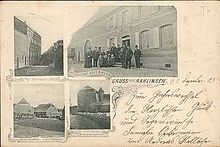
From 1871 until the end of the First World War , Rahlingen belonged to the German Empire as part of the realm of Alsace-Lorraine and was assigned to the Saargemünd district in the Lorraine district . In 2015, the canton of Rohrbach was dissolved and its communities integrated into the canton of Bitche .
Population development
| year | 1962 | 1968 | 1975 | 1982 | 1990 | 1999 | 2007 | 2017 |
| Residents | 881 | 843 | 857 | 827 | 781 | 793 | 833 | 766 |
Culture and sights
- If you walk through the village, you can still find craftsman's marks on many lintels.
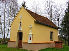
- Chapel and Hofgut Altkirch on the northern boundary of the district. Altkirch was the original parish in the area. The submerged town of Oldingen was here .
- The Chapel of St Wendelin remained from the submerged village of Weiher .
- Church of St Christophe from 1595. Between 1739 and 1745 an extensive renovation took place, during which the furnishings were also replaced. I.a. three altars were purchased by Johann Martersteck . The monumental retable of the main altar dates from the beginning of the 19th century. It is the largest retable in Bitscher Land.
- Jean Burgun's house near the church, built in 1796. The entrance area in particular is a demonstration of Rahlinger craftsmanship at the end of the 18th century.
- Rahling Castle, built at the beginning of the 14th century, was destroyed in 1380 by Johann II von Saar Werden. It was rebuilt in the 15th century, but abandoned by the Duke of Lorraine in 1572. A later partial restoration can be determined from a date engraving to the year 1620. The stair tower on the south facade is best preserved. Both entrance gates are decorated with six-petalled, entwined flowers. Overall, the building occupies a special position in the surrounding area and is strongly influenced by Alsatian shapes.
traffic
Rahling is on Departementsstrasse D 35 Rohrbach– Diemeringen .
Web links
- Rahling on bitscherland.fr (French)


