
Cáceres (Spain)
| Cáceres | |||
|---|---|---|---|
 Cáceres
|
|||
| coat of arms | Map of Spain | ||

|
|
||
| Basic data | |||
| Autonomous Community : |
|
||
| Province : | Cáceres | ||
| Comarca : | Llanos de Cáceres | ||
| Coordinates | 39 ° 28 ′ N , 6 ° 23 ′ W | ||
| Height : | 459 msnm | ||
| Area : | 1,750.33 km² | ||
| Residents : | 96.126 (Jan. 1, 2019) | ||
| Population density : | 54.92 inhabitants / km² | ||
| Postal code : | 10001-10005 | ||
| Municipality number ( INE ): | 10037 | ||
| administration | |||
| Mayor : | Elena Nevado del Campo ( PP ) | ||
| Website : | www.ayto-caceres.es | ||

Cáceres [ ˈkaθeɾes ] is the capital of the province of Cáceres in the Extremadura Autonomous Region in Spain . The old town of Cáceres is a UNESCO World Heritage Site . The area around the city is known for its extensive dehesas , grazed oak groves.
history
The city goes back to the Roman fortress Castra Caecilia , about 2.5 km northeast of Cáceres , which was built in 79 BC. Was created by Caecilius Metellus Pius . A Celtiberian settlement that dates back to around 35 BC. BC by the Roman proconsul Gaius Norbanus Flaccus under the name Colonia Norbensis Caesarina as a city, is also located in the vicinity of Cáceres. The necropolis of Arroyo de la Luz from the 4th to 7th centuries was excavated . In the 6th century , large parts of the city were destroyed by the invading Visigoths and only later rebuilt by the Moors . In 1139 the King of León , Ferdinand II (León) , managed to conquer the city. In 1165 the city was taken by Geraldo the Fearless , a Portuguese adventurer who created an independent principality in Extremadura, but was expropriated by force. Since the kingdom was unable to organize the defense, the city was handed over to the newly founded Santiagoorden . The city had to be abandoned as early as 1179 and only Alfonso IX. finally succeeded in capturing the city for the Kingdom of León in 1229 .
After Isabella I of Castile had won the dispute with Joan of Castile over the succession to the throne in Castile in the 15th century , she ordered all the towers of the houses whose owners had not supported her to be torn down. As a result, Cáceres was badly affected, only two palaces remained intact. Even today, Cáceres is nicknamed the Beheaded Capital .
After his abdication, Emperor Charles V retired to the nearby monastery of Yuste in 1556 and died there on September 21, 1558 as a result of malaria.
Under Franco
During the Spanish Civil War , the armed forces of Cáceres supported the military coup of July 17, 1936. After the takeover of power, the coup military in Cáceres mobilized around 1,000 supporters and immediately began occupying the most important places in the area and key strategic points on the border to Portugal . The repression by the coup d'état in Cáceres began immediately. More than 600 citizens were from the insurgent military shot . Those killed included the director Pedro Montero Rubio , the mayor of Cáceres, Antonio Canales Gonzalez , the mayor of Gallows , Maximo Calvo Cano and the president of the provincial government of Cáceres, Ramon Gonzalez Cid . The liquidations took place in downtown Cáceres. The successful uprising of the coup d'état in Cáceres made it easier to conquer the cities of Mérida and Badajoz in the coming months . On August 26, 1936, General Francisco Franco , the commander of the Spanish Legion , moved his headquarters to Cáceres.
The basic military training of a total of 700 Irish volunteers from the Irish Brigade also took place in the barracks of Cáceres . After military training in Cáceres, the Irish Brigade became part of the XV Bandera Irlandesa del Terico of the Spanish Legion . With its strength, the Irish Brigade was the largest foreign unit in the Spanish Legion. According to eyewitness reports, in August 1936, under Sergeant Lee's command , the Irish Brigade, in cooperation with the Guardia Civil, liquidated Republican soldiers after the Battle of Badajoz . Furthermore, Republican prisoners were shot dead by the Civil Guard on the grounds of the barracks for several days.
After Franco asked Hitler for military help, German tanks of the Panzerkampfwagen I model arrived in Cáceres via Seville. After the delivery of the German tanks, the German Colonel Wilhelm von Thoma of the Condor Legion also provided driver training for several months . After the driver training, the tank unit was relocated to Cubas de la Sagra , a place 30 kilometers south of Madrid on the Jarama River. The Irish brigade was relocated during the Battle of Jarama on February 17, 1937 to Ciempozuelos , a place five kilometers south of Cubas de la Sagra on the Jarama River.
Until the Battle of Jarama, Franco's headquarters were in Cáceres. Furthermore, the Aeródromo de Cáceres military airfield was located in Cáceres, which was also used as a base by the Condor Legion . On July 23, 1937, Cáceres was bombed by five Republican aircraft of the Soviet type Tupolev . Several buildings were hit in the air raid on Cáceres. In addition, 35 citizens of the city were killed.
From the mid-1990s to 2002, an unorganized open-air party, a so-called botellón, took place every Saturday on the square in front of the old town , in which up to 5000 young people took part. After the botellón parties had developed into a massive problem here as in other Spanish cities due to noise, pollution and sometimes rioting, they were banned nationwide in 2002.
Aeródromo de Cáceres
A few kilometers south on the N-630 road in the direction of Mérida , the Aeródromo de Cáceres military airfield used to be located . It was halfway between the towns of Valdesalor and Aldea del Cano . The airport was given up in 2005 due to the designation of a bird sanctuary (ZEPA) and the Aldea del Cano Way of St. James .
The airport did not have any paved runways. During the civil war , it was used by the air forces of the military coups at the start of the war. The Condor Legion used this space only occasionally, for the first time in early September 1936 before the official formation of the Condor Legion and by the 4th Squadron of Jagdgruppe 88 , which was set up in August 1936 . After the end of the war, the Ejercito del Aire continued to use the airfield, with the beginning of the jet age, the military lost interest in the site and finally gave it up at the end of the 1970s. Ultralight pilots from the local aviation club used the field for a number of years. Today the area is used for local recreation.
Attractions
| Old town of Cáceres | |
|---|---|
|
UNESCO world heritage |
|
| National territory: |
|
| Type: | Culture |
| Criteria : | iii, iv |
| Surface: | 9 ha |
| Reference No .: | 384 |
| UNESCO region : | Europe and North America |
| History of enrollment | |
| Enrollment: | 1986 (session 10) |
The old town of Cáceres was declared a UNESCO World Heritage Site in 1986. The old town is divided into two zones by its wall: inside and outside the wall. The part within the walls is what is known as the historic old town (Spanish: "Ciudad Monumental" o "Parte Antigua"). Since the Middle Ages, the city has been divided into four parishes: Santa María, San Mateo, Santiago and San Juan, which shape the structure of the city. The former two are inside the city walls, the latter two outside. Most of the historic buildings in Cáceres are located within the city walls and are divided into different zones. The Santa María district has formed around two squares: the “Plaza de Santa María” and the “Plaza de los Golfines”. The Cathedral of Santa María, around which there are a number of palaces, villas and noble houses, represents an important part of the district. The "Palacio der Carvajal" with its interior, courtyard and garden can be visited.
Other attractions are:
- The old town of Cáceres (UNESCO World Heritage since 1986).
- The Casa Museo Guayasamín , so far the only museum in Europe that is dedicated to the work of the Ecuadorian painter Osvaldo Guayasamín .
- The Aljibe cistern of Cáceres , carved into the rock at the highest point of the old town , the largest cistern construction in the world (UNESCO World Heritage since 1986).
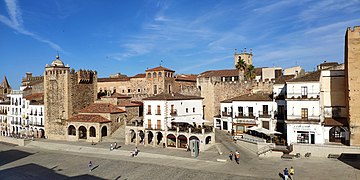
Casco viejo

Plaza Mayor

Santa Maria Church

San Francisco Javier Church
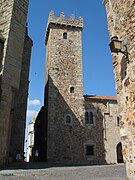
Tower of the Palacio de las Cigüeñas


education
The city is one of the main locations of the Universidad de Extremadura , which has existed since 1973 , the campus is located a little outside the actual city area.
sons and daughters of the town
- Francisco José de Ovando (1693–1755), politician
- Álvaro Gómez Becerra (1771–1855), politician
- Ada Salas (* 1965), poet
- Manolo (* 1965), football player
- Carlos Simón Vázquez (* 1965), Catholic clergyman
- César Sánchez (* 1971), football player
- Fernando Morientes (* 1976), football player
- José Antonio Pecharroman (* 1978), racing cyclist
literature
- Luis García Iglesias: CASTRA CAECILIA Cáceres, Spain . In: Richard Stillwell et al. a. (Ed.): The Princeton Encyclopedia of Classical Sites. Princeton University Press, Princeton NJ 1976, ISBN 0-691-03542-3 .
Web links
- Tourist information on Cáceres - official website
- Caceres - the official website of the Extremadura region
- Castra Caecilia in the Pleiades database
- Norba / Col. Norbensis Caesarina in the Pleiades database
Individual evidence
- ↑ Cifras oficiales de población resultantes de la revisión del Padrón municipal a 1 de enero . Population statistics from the Instituto Nacional de Estadística (population update).
- ↑ Cáceres - translation into German - Langenscheidt dictionary Spanish-German. Retrieved August 3, 2018 .
- ↑ [1] , Eyewitness, Ireland and the spanish war, A bandera volunteer remembers, Niamh McGuinness, accessed May 1, 2012
- ↑ [2] , Eyewitness, Ireland and the spanish war, Tells of Exploits as Rebel Deserter, McDaniel from County Monaghan, accessed May 1, 2012
- ↑ [3] , Eyewitness, Ireland and the spanish war, Fighting for Franco, Des Ryan, accessed May 1, 2012
- ↑ World Heritage List - German UNESCO Commission.Retrieved August 29, 2014.

Historic city centers:
Alcalá de Henares with university (1998) |
Ávila with churches outside the city wall (1985) |
Cáceres (1986) |
Cordoba with Mosque-Cathedral (1984) |
Cuenca (1996) |
Granada with Alhambra and Generalife Palace (1984) |
Salamanca (1988) |
San Cristóbal de La Laguna (1999) |
Santiago de Compostela (1985) |
Segovia with Aqueduct (1985) |
Toledo (1986)
Buildings:
Architecture of the Mudéjares in Aragón (1986) |
Monuments of Oviedo and the Kingdom of Asturias (1985) |
Escorial in Madrid (1984) |
Tower of Hercules (2009) |
Burgos Cathedral (1984) |
Cathedral , Alcázar and Archivo General de Indias in Seville (1987) |
Catalan Romanesque churches in the Vall de Boí (2000) |
Poblet Monastery (1991) |
Monasteries of San Millán de Yuso and San Millán de Suso (1997) |
Royal Monastery of Santa María de Guadalupe (1993) | Monumental Renaissance buildings by Úbeda and Baeza (2003) |
Palau de la Música Catalana and Hospital de la Santa Creu i Sant Pau in Barcelona (1997) |
Puente de Vizcaya (2006) |
Historic sites of mercury mining: Almadén and Idrija (2012) |
Roman city walls of Lugo (2000) |
Valencia Silk Exchange (1996) |
Works by Antoni Gaudí (1984)
Archaeological sites:
Atapuerca (2000) |
Antequera Dolmen (2016) |
Rock art of the Mediterranean on the Iberian Peninsula (1998) |
Altamira Cave and Paleolithic Cave Paintings in Northern Spain (1985) |
Las Médulas (1997) |
Madīnat az-zahrāʾ (2018) |
Mérida (1993) |
Siega Verde * (2010) |
Tarraco (2000)
Cultural and natural landscapes:
Old beech forests and primeval beech forests of the Carpathian Mountains and other regions of Europe (2017, N) |
Aranjuez (2001, K) |
Ibiza (1999, K / N) |
Way of St. James (1993, K) |
Monte Perdido (1997, K / N) |
Doñana National Park (1994, N) |
Garajonay National Park (1986, N) |
Teide National Park (2007, N) |
Palm grove of Elche (2000, K) |
Serra de Tramuntana (2011, K)
* Expansion of the archaeological sites in Vale do Côa , Portugal;
Abadía | Abertura | Acebo | Acehúche | Aceituna | Ahigal | Alagón del Río | Albalá | Alcántara | Alcollarín | Alcuéscar | Aldea del Cano | La Aldea del Obispo | Aldeacentenera | Aldeanueva de la Vera | Aldeanueva del Camino | Aldehuela de Jerte | Alía | Aliseda | Almaraz | Almoharín | Arroyo de la Luz | Arroyomolinos | Arroyomolinos de la Vera | Baños de Montemayor | Barrado | Belvís de Monroy | Benquerencia | Berrocalejo | Berzocana | Bohonal de Ibor | Botija | Brozas | Cabañas del Castillo | Cabezabellosa | Cabezuela del Valle | Cabrero | Cáceres | Cachorrilla | Cadalso | Calzadilla | Caminomorisco | Campillo de Deleitosa | Campo Lugar | Cañamero | Cañaveral | Carbajo | Carcaboso | Carrascalejo | Casar de Cáceres | Casar de Palomero | Casares de las Hurdes | Casas de Don Antonio | Casas de Don Gómez | Casas de Millán | Casas de Miravete | Casas del Castañar | Casas del Monte | Casatejada | Casillas de Coria | Castañar de Ibor | Ceclavín | Cedillo | Cerezo | Cilleros | Collado | Conquista de la Sierra | Coria | Cuacos de Yuste | La Cumbre | Deleitosa | Descargamaría | Eljas | Escurial | Fresnedoso de Ibor | Galisteo | Garciaz | La Garganta | Garganta la Olla | Gargantilla | Gargüera | Garrovillas de Alconétar | Garvín | Gata | El Gordo | La Granja | Guadalupe | Guijo de Coria | Guijo de Galisteo | Guijo de Granadilla | Guijo de Santa Bárbara | Herguijuela | Hernán-Pérez | Herrera de Alcántara | Herreruela | Hervás | Higuera | Hinojal | Holguera | Hoyos | Huélaga | Ibahernando | Jaraicejo | Jaraíz de la Vera | Jarandilla de la Vera | Jarilla | Jerte | Ladrillar | Logrosán | Losar de la Vera | Madrigal de la Vera | Madrigalejo | Madroñera | Majadas | Malpartida de Cáceres | Malpartida de Plasencia | Marchagaz | Mata de Alcántara | Membrío | Mesas de Ibor | Miajadas | Millanes | Mirabel | Mohedas de Granadilla | Monroy | Montánchez | Montehermoso | Moraleja | Morcillo | Navaconcejo | Navalmoral de la Mata | Navalvillar de Ibor | Navas del Madroño | Navezuelas | Nuñomoral | Oliva de Plasencia | Palomero | Pasarón de la Vera | Pedroso de Acim | Peraleda de la Mata | Peraleda de San Román | Perales del Puerto | Pescueza | La Pesga | Piedras Albas | Pinofranqueado | Piornal | Plasencia | Plasenzuela | Portaje | Portezuelo | Pozuelo de Zarzón | Puerto de Santa Cruz | Rebollar | Riolobos | Robledillo de Gata | Robledillo de la Vera | Robledillo de Trujillo | Robledollano | Romangordo | Rosalejo | Ruanes | Salorino | Salvatierra de Santiago | San Martín de Trevejo | Santa Ana | Santa Cruz de la Sierra | Santa Cruz de Paniagua | Santa Marta de Magasca | Santiago de Alcántara | Santiago del Campo | Santibáñez el Alto | Santibáñez el Bajo | Saucedilla | Segura de Toro | Serradilla | Serrejón | Sierra de Fuentes | Talaván | Talaveruela de la Vera | Talayuela | Tejeda de Tiétar | Tiétar | Toril | Tornavacas | El Torno | Torre de Don Miguel | Torre de Santa María | Torrecilla de los Ángeles | Torrecillas de la Tiesa | Torrejón el Rubio | Torrejoncillo | Torremenga | Torremocha | Torreorgaz | Torrequemada | Trujillo | Valdastillas | Valdecañas de Tajo | Valdefuentes | Valdehúncar | Valdelacasa de Tajo | Valdemorales | Valdeobispo | Valencia de Alcántara | Valverde de la Vera | Valverde del Fresno | Viandar de la Vera | Vegaviana | Villa del Campo | Villa del Rey | Villamesías | Villamiel | Villanueva de la Sierra | Villanueva de la Vera | Villar de Plasencia | Villar del Pedroso | Villasbuenas de Gata | Zarza de Granadilla | Zarza de Montánchez | Zarza la Mayor | Zorita