Elsdorf (Rhineland)
| coat of arms | Germany map | |
|---|---|---|

|
Coordinates: 50 ° 56 ' N , 6 ° 34' E |
|
| Basic data | ||
| State : | North Rhine-Westphalia | |
| Administrative region : | Cologne | |
| Circle : | Rhein-Erft district | |
| Height : | 76 m above sea level NHN | |
| Area : | 66.17 km 2 | |
| Residents: | 21,807 (Dec. 31, 2019) | |
| Population density : | 330 inhabitants per km 2 | |
| Postal code : | 50189 | |
| Primaries : | 02274, 02271 | |
| License plate : | BM | |
| Community key : | 05 3 62 016 | |
| LOCODE : | DE ESD | |
| City structure: | 14 districts | |
City administration address : |
Gladbacher Strasse 111 50189 Elsdorf |
|
| Website : | ||
| Mayor : | Andreas Heller ( CDU ) | |
| Location of the city of Elsdorf in the Rhein-Erft district | ||

Elsdorf is a town in the northern part of the Rhein-Erft district in the Rhineland in North Rhine-Westphalia .
geography
Geographical location
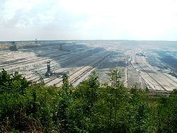
Elsdorf is a rural municipality with city rights 30 kilometers west of Cologne between Bergheim and Jülich in the Rhenish lignite district . In the southwest, the urban area meets the Hambach opencast mine , which takes up large parts of the urban area. The districts of Etzweiler , Tanneck and the Gesolei settlement were relocated. The resettlement place is Neu-Etzweiler . The original plans for the Hambach opencast mine provided for the later expansion of the opencast mine up to today's A 61 ("Hambach II"). 2.015 billion m³ of brown coal are still stored here today. That is significantly more than the 1.650 billion m³ forecast in the Garzweiler II opencast mine (= Frimmersdorf West-West). For the dismantling, however, a relocation of all districts would be necessary.
Elsdorf borders on: the town of Bedburg , the district town of Bergheim , the Kolping town of Kerpen (all in the same district), the communities Merzenich (indirect), Niederzier (indirect) and Titz (all in the district of Düren )
City structure
(registered population as of April 30, 2019)
| District | Residents |
|---|---|
| Angelsdorf | 2,155 |
| Berrendorf-Wüllenrath | 3,499 |
| Elsdorf (with Desdorf) | 6,523 |
| Esch | 2,716 |
| Frankeshoven | 39 |
| Giesendorf | 1,307 |
| Grouven (with Brockendorf) | 640 |
| Heppendorf (with stammering) | 1,862 |
| New Etzweiler | 607 |
| Niederembt | 1,373 |
| Oberembt | 1,100 |
| Tollhausen | 241 |
| Widdendorf | 77 |
| total | 22,139 |
Residents
(as of December 31st)
|
|
|
history
The roots of Elsdorf go back to the time when what is now the city area was settled by the Franks . Excavations of a Frankish burial ground show the first settlements towards the end of the 5th century.
According to a legend, the name Elsdorf comes from Egilhard (also Eilhard), an abbot of the imperial abbey Kornelimünster near Aachen . According to tradition, he was killed in 881 during a Norman invasion in the forest between Elsdorf and Bergheim . After the development via Egilo-, Egils- and Eilsdorf, today's name Elsdorf was finally created.
In the Roman period between the first and fourth centuries AD, there is evidence of a Roman vicus in Elsdorf, which was located on the Roman road from Cologne to Aachen and on to Boulogne-sur-Mer, which is now usually referred to as Via Belgica . This can be seen well on the Tranchot map and is still easy to follow today as Köln-Aachener Straße and further east as Römerstraße to Grouven (Elsdorf) and Thorr . In the area of the vicus, the name of which has not been passed down, another Roman road, coming from the south-west, converged on the road to Cologne. The outlines of a Gallo-Roman circulating temple were proven on this, while houses up to 25 m long aligned perpendicular to the street were detected on the Via Belgica .
Elsdorf has belonged to the Bergheim office in the Duchy of Jülich since the Middle Ages . In 1794 French revolutionary troops occupied the place and Elsdorf came to the Mairie Esch in the canton Bergheim in the Arrondissement de Cologne in the Département de la Roer .
In 1815 Elsdorf came to the Kingdom of Prussia and to the Bergheim district in the Cologne district .
The Neuss - Düren railway line with Elsdorf West station was built in 1869. As a result, the population of the place increased strongly, and Elsdorf rose to the center of the places that make up today's city.
Emil Pfeifer , his son Valentin Pfeifer and Eugen Langen built the first Pfeifer & Langen sugar factory in 1870 .
The municipality of Heppendorf was merged with the Esch office in 1937, which was renamed the Elsdorf office in 1938.
In its current expansion, the municipality has only existed since the regional reform (cf. § 8 Cologne Law ), in which on January 1, 1975 the previously independent municipalities Angelsdorf, Elsdorf, Esch, Heppendorf, Niederembt and Oberembt were combined to form the municipality of Elsdorf.
On January 1, 2011, Elsdorf was granted city rights. Associated with this were the establishment of a youth and building authority.
At the beginning of the 2014/2015 school year, the Elsdorfer Comprehensive School in the Angelsdorf school center started operating. Schools in the Realschule and Hauptschule in Elsdorf are running out, so that in future there will only be one type of school in Elsdorf.
politics
|
Allocation of seats in the city council
A total of 36 seats
|
Council election 2014
Turnout: 46.71% (2009: 55.02%)
% 50 40 30th 20th 10
0
41.79
34.80
8.51
4.45
10.45
Gains and losses
compared to 2009
% p 12 10 8th 6th 4th 2
0
-2 -4 -6 -2.78
-1.59
-1.43
-4.65
+10.45
|
City council
The city council is the local people's representative body for the city of Elsdorf. The citizens decide on the composition every five years. The last election took place on May 25, 2014.
Town twinning
In 1990 Elsdorf signed a town partnership with the northern French city of Bully-les-Mines and the neighboring municipality of Aix-Noulette (both in the Pas-de-Calais department ).
Culture and sights
Buildings worth seeing
- Grouven-Brockendorf: Gutskapelle St. Bartholomäus from 1680, restored after war damage in 1950/1956.
- Heppendorf-Stammeln: Stammeln Castle , rectangular castle complex with inner courtyard. The two wings of the western corner with a round and a rectangular corner tower date from the late 16th century
- Niederembt: House Richardshoven, a Richardus von Emde is attested in 1099, a Godart von Richardshovenm in 1364, square system of a former moated castle, square tower with two axes, three storeys, curved hood and closed lantern
- Niederembt: White House, Hochstrasse 1, half-timbered house, 17th century
- Oberembt: House 'Zur Löv', arbor house from 1644, is the only preserved arbor house in the Rhein-Erft district.
- Angelsdorf: Catholic parish church St. Lucia (1535), restored in 1865
- Angelsdorf: House Angelsdorf, manor, 1750, in the western part remains from the 16th century
- Berrendorf: Catholic parish church St. Michael (1524), restored in 1825, extended in 1903 to include a transept and a new choir, Palm Sunday 2011 fully usable again after a 4-year renovation
- Desdorf (Brachelsburg), around 1700.
- Elsdorf: Catholic parish church of St. Mary's birth: tower around 1225.
- Elsdorf: Roman milestone on Cologne-Aachener-Strasse, corner of Eisenbahnstrasse.
- Elsdorf: War cemetery in the forest cemetery.
- Elsdorf: Jewish cemetery on Nussbaumallee , occupancy period 1847 to 1935, in it relocations from the former Jewish cemeteries in Glesch and Niederembt due to lignite mining
- Esch: Catholic parish church of St.Laurentius, late Gothic west tower with stair tower
- Grouven: Chapel of St. Brigida , built in 1648, extended by a hall in 1949. Behind the altar, lowered by two steps, a floor made of upright clay tiles with colored glazes (waste product from pottery kilns) in an irregular pattern
- Grouven: Grouven Castle , manor around 1500, 1691 and expanded in the 19th century.
- Heppendorf: late Gothic church of St. Dionysios with two-storey Romanesque west tower from the end of the 12th century, three bells from the years 1467, 1473 and 1490.
- Neu-Etzweiler: Chapel of St. Hubertus, the crucifix from 1480 was taken over from the St. Hubertuskirche of the old Etzweiler, which has now been excavated.
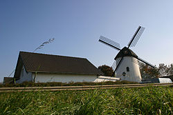
- Niederembt: Road towards Esch: Old windmill, early 19th century.
- Oberembt: Catholic parish church of St. Simon and Judas Thaddäus (late 14th century to early 16th century)
- Tollhausen : St. Margaretha Way Chapel, therein St. James, early 16th century master Tilmann, Cologne
- Oberembt: In Oberembt there is a small Protestant church that is part of the Ev. Kirchherten parish belongs. It was built in 1960 in a settlement that was created for refugees from the former eastern regions after the Second World War . The bell tower dates from 1970. Today it is still used regularly for church services and women's groups.
- Terra Nova Speedway: Former lignite conveyor belt route, which now connects Elsdorf with Bergheim, Bedburg and Glesch as a cycle expressway.
Parks
The Sittarder Hof, located near Berrendorf-Wüllenrath and Heppendorf , which belonged to the Pfeifer entrepreneurial family of the Elsdorfer Zuckerfabrik Pfeifer & Langen , had a beautiful garden and park until its final demolition in 2011. The Sittarder Hof was located in a safety zone that was formed around the edge of the Hambach opencast mine and could therefore not be preserved.
Open pit viewpoints
An insight into the Hambach opencast mine adjacent to Elsdorf is offered by:
- Viewpoint near Elsdorf-Angelsdorf
- Lookout point at Elsdorf-Giesendorf
- Forum: terra nova
Sports
Elsdorf offers a wide range of sports and sports facilities. The judo department of ASG Elsdorf achieved its greatest successes by winning the German championship for women three times. The ASG tennis department has eight courts. ASG Elsdorf was founded in 1967 by three friends Paul Kohl, Hans Packmohr and Willy Schmitz.
As a result of years of successful youth work in the basketball department of the ASG, several district and vice district championship titles were followed by the promotion of the U18 team to the major league for the 2010/2011 season.
The first women’s team of table tennis friends Grün-Weiß Elsdorf plays in the major league and the first men’s team at association level.
The three largest football clubs in the city of Elsdorf are SC 08 Elsdorf, Rot-Weiß Berrendorf and FC Grün-Weiß Etzweiler. There are other clubs in Niederembt ( Blau-Weiß Niederembt ), Oberembt and Heppendorf.
Regular events
The carnival plays an important role in Elsdorf as in the entire Rhineland. The carnival company KG Fidelio organizes the parade ("Sugar Cube Parade") every year on Carnival Sunday. The connection to the church is established through the youth organization KaJuJa, which organizes a meeting with local workers every year. The dialogue between the farmer and the Viennese is part of the regular cast .
Economy and Infrastructure
traffic
Road traffic
Motorway connections:
Federal highways:
Rail transport
Elsdorf used to have two stations: Kleinbahnhof Elsdorf Ost and Bahnhof Elsdorf West. There was no rail connection between the two.
Elsdorf station : On September 1, 1869, Elsdorf was connected to the Neuss - Düren line. Up until June 1, 1991, all passenger trains ran on the route from Neuss to Düren. In the eighties the station building was demolished and replaced by a small shelter. From May 27, 1995 passenger traffic in the Bedburg - Düren section was discontinued, and goods traffic on December 31 of the same year. It was shut down on June 2, 1996. The Düren - Elsdorf section ran in the area of what is now the Hambach open-cast lignite mine and was therefore excavated. The Elsdorf - Bedburg section was initially used for freight traffic, but was later shut down and dismantled due to lack of demand. There is now a parking lot at the site of the former train station. The former route through Elsdorf is now a park (local recreation area) for cyclists and walkers. A small part went into the possession of the Elsdorfer sugar factory .
Kleinbahnhof Elsdorf Ost : The Kleinbahnhof belonged to the Bergheimer Kreisbahn . From the beginning he had his own well and from 1900 he had a telephone. This is where the initially meter-gauge (1000 mm), from 1903 three-track also standard-gauge (1435 mm) route in the direction of Zieverich began . From 1938 on there were six passenger trains every day, all of which drove via Zieverich to Bergheim. Some trains ran beyond Bergheim on the Bergheim - Rommerskirchen railway to Rommerskirchen or on the branch line to the Fortuna mine. Passenger traffic was discontinued on May 28, 1961, and freight traffic was discontinued six years later, on May 28, 1967. After a long period of vacancy, the dilapidated station building at the east end of Eisenbahnstrasse was sold and converted into a Cafe Dampflok from 1997 to 1999 by a private investor . A decommissioned steam storage locomotive from the sugar factory is parked there.
Local transport
The Elsdorf bus station is served by the following REVG bus lines:
| line | Line route |
|---|---|
| 915 | Neu-Etzweiler - Elsdorf - Zieverich - Bergheim train station - Quadrath-Ichendorf train station |
| 937 | School traffic from Oberembt / Neu-Etzweiler to Bergheim and back |
| 941 | Elsdorf Busbf - Berrendorf - Heppendorf - Ahe - Sindorf - Horrem Bf |
| 950 | Titz-Rödingen - Oberembt - Niederembt - Esch - Angelsdorf - Elsdorf bus station - Berrendorf - Thorr - Bergheim - Quadrath-Ichendorf - Horrem Abzw. - Königsdorf - Weiden Zentrum Stadtbahn |
| 988 | School traffic from all parts of the city to Bedburg school center or individual trips to Bedburg train station , as well as school traffic within Elsdorf |
| 283 | Supplementary line from Elsdorf bus station to Titz Rödingen (on to Jülich ; operated twice a day by BVR ) |
A bus connection to Merzenich or Düren is not possible because of the Hambach opencast mine .
Established businesses
The largest employers in the area are RWE Power AG and the Pfeifer & Langen sugar factory . The processing of sugar beets ended in 2006, the production of special types of sugar (sugar loaf, candy, powdered or lump sugar) continues in Elsdorf. Until 2014, the mattress manufacturer Matratzen Factory Outlet had its headquarters in Elsdorf.
The Back Europ purchasing association has its headquarters in Elsdorf . The Schneider bakery , which operates its branches in the entire Rhein-Erft district as well as in Cologne and other cities bordering the Rhein-Erft district, is also headquartered in Elsdorf (industrial park).
jurisdiction
Elsdorf belongs to the district court district Bergheim .
Personalities
- Werner Marx (1746–1806), Vicar General of the Archbishop of Cologne, was born in Elsdorf.
- Eugen Langen (1833–1895), entrepreneur, engineer and inventor, co-founder of the Elsdorf sugar factory Pfeifer & Langen . A street and the secondary school are named after him.
- Valentin Pfeifer (1837–1909), sugar factory owner, was a co-founder of the Elsdorf sugar factory Pfeifer & Langen. A street is named after him.
- Heinrich Wolff (1843–1924), builder of the sugar factory and several churches in the vicinity of Elsdorf. Developed the first districts
- Richard Jansen (1878–1941), architect
- Josef Becker (1895–1966), physician and university professor
- Richard Mummendey (1900–1978), book scholar and author, was born in Angelsdorf.
- Josef Heinrichs (1919–1994), politician, Member of the State of North Rhine-Westphalia, was born in Berrendorf.
- Peter W. Jansen (1930–2008), film critic and journalist, was born in Elsdorf.
- Herbert Lepper (1935–2014), German archivist and historian
- Diana Billaudelle (1974–2016), illustrator and graphic artist, lived in Elsdorf.
- Andreas Rumler (* 1955), poet, non-fiction author, literary critic, lives in Elsdorf.
- Manfred Johannes Junggeburth (* 1956), journalist and artist, was born in Elsdorf.
- Eko Fresh (* 1983), German rapper of Turkish origin, lives in Elsdorf.
literature
- Annaliese Ohm, Albert Verbeek: The monuments of the Rhineland 17th vol. Bergheim district. 3 volumes, Düsseldorf 1971, ISBN 3-508-00186-5 .
- Bernhard Gondorf: The castles of the Eifel and their peripheral areas. A lexicon of the "permanent houses" . J. P. Bachem, Cologne 1984, ISBN 3-7616-0723-7 , p. 66 f . (Berrendorf: Grouven, Desdorf: Brachelsburg, Esch: Fronhof, Niederembt: Richardshoven, Oberemt: Burghügel, Reuschenberg: Burg).
Web links
- Website of the city of Elsdorf
- Historical Elsdorf economic and traffic events
- Churches in Elsdorf
- Ev. Oberembt Church
Individual evidence
- ↑ Population of the municipalities of North Rhine-Westphalia on December 31, 2019 - update of the population based on the census of May 9, 2011. State Office for Information and Technology North Rhine-Westphalia (IT.NRW), accessed on June 17, 2020 . ( Help on this )
- ↑ Rhineland district map with relocated locations, current operating areas, type of recultivation and approved open-cast mine extensions 377 kB, accessed on April 3, 2010.
- ↑ LANUV graphics card of the planned lakes and coal mines Hambach, Garzweiler and Inden, status: July 22, 2009, overview map of the State Office for Nature, Environment and Consumer Protection North Rhine-Westphalia (LANUV) for the remaining open pit lakes Hambach, Garzweiler and Inden ( Memento from 27. September 2009 in the Internet Archive )
- ↑ Map of the lignite deposits and table of the possible opencast mines with details of the coal reserves from an investigation by Rheinbraun and the state government on which the decision for the Garzweiler II opencast mine (= Frimmersdorf West-West) in the 1980s is based ( page no longer available , Search in web archives ) Info: The link was automatically marked as defective. Please check the link according to the instructions and then remove this notice.
- ^ Population Elsdorf 2019 (PDF) City of Elsdorf, accessed on August 12, 2019 .
- ↑ Jeanne-Nora Andrikopolou-Strack: The vicus of Elsdorf . P. 59 ff. In: Landschaftsverband Rheinland - Rheinische Bodendenkmalpflege (Ed.): Erlebnisraum Römerstraße - Via Belgica . print'n'press-Verlag Aachen 2008, ISBN 978-3-935522-01-4
- ↑ Martin Bünermann, Heinz Köstering: The communities and districts after the municipal territorial reform in North Rhine-Westphalia . Deutscher Gemeindeverlag, Cologne 1975, ISBN 3-555-30092-X .
- ↑ City rights for Elsdorf ( Memento of the original from January 2, 2011 in the Internet Archive ) Info: The archive link was inserted automatically and has not yet been checked. Please check the original and archive link according to the instructions and then remove this notice. , Kölner Stadtanzeiger
- ^ City of Elsdorf. Council election - overall result. May 25, 2014, accessed April 25, 2015 .
- ↑ Liga Jugendoberliga 1 U18 male ( Memento from January 6, 2012 in the Internet Archive )
- ^ Museumsverein Elsdorf shop window exhibition


