Fontenay-lès-Briis
| Fontenay-lès-Briis | ||
|---|---|---|
|
|
||
| region | Île-de-France | |
| Department | Essonne | |
| Arrondissement | Palaiseau | |
| Canton | Dourdan | |
| Community association | Pays de Limours | |
| Coordinates | 48 ° 37 ' N , 2 ° 9' E | |
| height | 59-170 m | |
| surface | 9.72 km 2 | |
| Residents | 2,149 (January 1, 2017) | |
| Population density | 221 inhabitants / km 2 | |
| Post Code | 91640 | |
| INSEE code | 91243 | |
| Website | http://www.mairie-fontenay-les-briis.fr | |
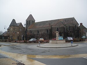
 Saint Martin and Mairie Church |
||
Fontenay-lès-Briis is a French commune with 2,149 inhabitants (as of January 1, 2017) in the Essonne department of the Île-de-France region ; it belongs to the Arrondissement Palaiseau and the Canton of Dourdan .
geography
The municipality is located 30 kilometers southwest of Paris . The municipality is part of the Haute Vallée de Chevreuse Regional Nature Park . Neighboring municipalities of Fontenay-lès-Briis are Janvry in the north, Marcoussis in the northeast, Bruyères-le-Châtel in the east and south, Saint-Maurice-Montcouronne and Courson-Monteloup in the southwest and Briis-sous-Forges in the west.
The municipality is drained by the Charmoise towards the south, where it flows into the Rémarde .
history
The place is already mentioned in the Charte de Clotilde (March 10, 673).
Population development
| year | 1968 | 1975 | 1982 | 1990 | 1999 | 2009 |
| Residents | 929 | 1,168 | 1,204 | 1,567 | 1,707 | 1,832 |
Attractions
- Théatre de Bligny , built in 1934
literature
- Le Patrimoine des Communes de l'Essonne. Flohic Éditions, Volume 2, Paris 2001, ISBN 2-84234-126-0 , pp. 528-530.
