La Ville-du-Bois
| La Ville-du-Bois | ||
|---|---|---|

|
|
|
| region | Île-de-France | |
| Department | Essonne | |
| Arrondissement | Palaiseau | |
| Canton | Longjumeau | |
| Community association | Paris-Saclay | |
| Coordinates | 48 ° 40 ′ N , 2 ° 16 ′ E | |
| height | 82-162 m | |
| surface | 3.62 km 2 | |
| Residents | 7,753 (January 1, 2017) | |
| Population density | 2,142 inhabitants / km 2 | |
| Post Code | 91620 | |
| INSEE code | 91665 | |
| Website | http://www.la-ville-du-bois.fr/ | |
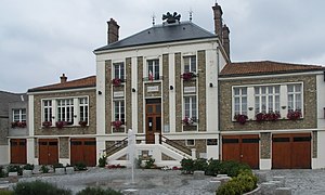
 City Hall |
||
La Ville-du-Bois is a French town with 7753 inhabitants (at January 1, 2017) in the department of Essonne in the region of Ile-de-France .
geography
The city is about 27 kilometers from the center of Paris . The closest municipalities are Nozay , Montlhéry and Longpont-sur-Orge .
Population development
| year | 1962 | 1968 | 1975 | 1982 | 1990 | 1999 | 2006 |
| Residents | 2,052 | 2,594 | 3,334 | 4,067 | 5,404 | 5,901 | 6,825 |
politics
For mayor of the town in 2008 Jean-Pierre Meur (was DVD ) selected. He will remain mayor of the city until 2014.
economy
To the north is the Center Commercial de La-Ville-du-Bois , a large shopping center. The city's unemployment rate is around 7%.
traffic
The main artery is the four-lane Route nationale 20 (N20), which leads north to the city center of the capital Paris. Very close lying motorway A10 ( L'Aquitaine ).
Town twinning
- Tirschenreuth , Germany (since 2001)
literature
- Le Patrimoine des Communes de l'Essonne. Flohic Éditions, Volume 2, Paris 2001, ISBN 2-84234-126-0 , pp. 817-819.
Web links
Commons : La Ville-du-Bois - Collection of images, videos and audio files
