Forges-les-Bains
| Forges-les-Bains | ||
|---|---|---|
|
|
||
| region | Île-de-France | |
| Department | Essonne | |
| Arrondissement | Palaiseau | |
| Canton | Dourdan | |
| Community association | Pays de Limours | |
| Coordinates | 48 ° 38 ' N , 2 ° 6' E | |
| height | 92-169 m | |
| surface | 14.58 km 2 | |
| Residents | 3,851 (January 1, 2017) | |
| Population density | 264 inhabitants / km 2 | |
| Post Code | 91470 | |
| INSEE code | 91249 | |
| Website | http://www.forges-les-bains.fr/ | |
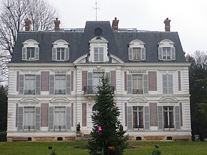
 Forges-les-Bains town hall |
||
Forges-les-Bains is a French commune with 3851 inhabitants (as of January 1, 2017) in the Essonne department of the Île-de-France region ; it belongs to the Arrondissement Palaiseau and the Canton of Dourdan . The inhabitants are called Forgeois .
geography
The municipality is part of the Haute Vallée de Chevreuse Regional Nature Park . Forges-les-Bains is located about 25 kilometers southwest of Paris in the Hurepoix region and is surrounded by the neighboring communities of Limours in the north, Briis-sous-Forges in the east, Vaugrigneuse in the southeast, Angervilliers in the south and southwest and Bonnelles in the west.
The A10 autoroute runs through the municipality (without a connection) .
Population development
| year | 1962 | 1968 | 1975 | 1982 | 1990 | 1999 | 2006 | 2011 |
| Residents | 920 | 1,164 | 1,374 | 2.017 | 2,757 | 3,229 | 3,651 | 3,748 |
Attractions
- Notre-Dame-de-l'Assomption-de-la-Très-Sainte-Vierge church from the 12th century
- Forges-les-Bains castle from the 17th and 18th centuries, monument historique since 1963
- Wash houses
literature
- Le Patrimoine des Communes de l'Essonne. Flohic Éditions, Volume 2, Paris 2001, ISBN 2-84234-126-0 , pp. 531-534.
Web links
Commons : Forges-les-Bains - Collection of images, videos and audio files


