Villiers-le-Bâcle
| Villiers-le-Bâcle | ||
|---|---|---|
|
|
||
| region | Île-de-France | |
| Department | Essonne | |
| Arrondissement | Palaiseau | |
| Canton | Gif-sur-Yvette | |
| Community association | Paris-Saclay | |
| Coordinates | 48 ° 44 ' N , 2 ° 8' E | |
| height | 80-161 m | |
| surface | 6.03 km 2 | |
| Residents | 1,237 (January 1, 2017) | |
| Population density | 205 inhabitants / km 2 | |
| Post Code | 91190 | |
| INSEE code | 91679 | |
| Website | http://www.ville-villierslebacle.fr/ | |
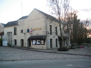
 Town hall (Mairie) of Villiers-le-Bâcle |
||
Villiers-le-Bâcle is a French commune with 2,059 inhabitants (at January 1, 2017) in the department of Essonne in the region of Ile-de-France . The municipality belongs to the arrondissement Palaiseau and the canton Gif-sur-Yvette (until 2015: canton Bièvres ). The inhabitants are called Villebaclais .
geography
Villiers-le-Bâcle is located around 21 kilometers southwest of Paris . Villiers-le-Bâcle is surrounded by the neighboring communities of Toussus-le-Noble in the north, Saclay in the east, Saint-Aubin in the southeast, Gif-sur-Yvette in the south, Saint-Rémy-lès-Chevreuse in the southwest and Châteaufort in the west.
Population development
| year | 1962 | 1968 | 1975 | 1982 | 1990 | 1999 | 2006 | 2013 |
| Residents | 238 | 256 | 225 | 750 | 953 | 1,093 | 1,156 | 1,237 |
| Source: Cassini and INSEE | ||||||||
Community partnerships
Partnerships exist with the British community of Bildeston in Suffolk (England) since 1989 and with the Canadian community of Waterville in the province of Québec.
Attractions
See also: List of Monuments historiques in Villiers-le-Bâcle
- Villiers-le-Bâcle castle from the 17th century, a historic monument since 1946
- Atelier Foujita, monument historique since 1994, home of the painter Tsugouharu Foujita
- Wash house
literature
- Le Patrimoine des Communes de l'Essonne. Flohic Éditions, Volume 1, Paris 2001, ISBN 2-84234-126-0 , pp. 123-131.

