
Kirchberg an der Jagst
| coat of arms | Germany map | |
|---|---|---|

|
Coordinates: 49 ° 12 ' N , 9 ° 59' E |
|
| Basic data | ||
| State : | Baden-Württemberg | |
| Administrative region : | Stuttgart | |
| County : | Schwäbisch Hall | |
| Height : | 384 m above sea level NHN | |
| Area : | 40.93 km 2 | |
| Residents: | 4393 (December 31, 2018) | |
| Population density : | 107 inhabitants per km 2 | |
| Postal code : | 74592 | |
| Area code : | 07954 | |
| License plate : | SHA, BK , CR | |
| Community key : | 08 1 27 046 | |
| LOCODE : | DE KGJ | |
City administration address : |
Schloßstraße 10 74592 Kirchberg an der Jagst |
|
| Website : | ||
| Mayor : | Stefan Ohr (independent) | |
| Location of the town of Kirchberg an der Jagst in the Schwäbisch Hall district | ||
  |
||

Kirchberg an der Jagst is a country town in the Schwäbisch Hall district in the Franconian north-east of Baden-Württemberg .
geography
Geographical location
The metropolitan area of Kirchberg is a little overweight the left side on both sides of the middle Jagst whose steeply with carved limestone - Meander it crosses west-north-west. The wide, somewhat wavy plateaus above the river valley, mostly lying in the open fields and heavily used for agriculture, are part of the Hohenlohe Plain , on the left side of the valley especially the Hall Plain . Except for a small portion of the very south, the precipitation over the Schmerach drain and the Bühler to the digester, they are on the smaller side streams of Jagst the lobes Hausen Grundbach to below opening out of Diembot Scherr Bach drained, which in the lower course by steep cut sides sound to Drop in flow level. (See list of the tributaries of the Jagst ) The highest point on the city boundary is on its eastern border with the municipality of Satteldorf in a forest area at a little over 472 m above sea level. NHN , but mostly the plateaus are between 400 and 450 m above sea level. NHN . The Jagst in its trough valley flows at 358 m above sea level. NHN in the district and below 317 m above sea level. NHN off again.
The walled settlement core of the eponymous town of Kirchberg lies on a north-northeast spur separated from the adjacent plateau by a flat saddle above the Jagsttal , between an abandoned southern loop of the Jagst up the valley in the east and a southern loop of the river in the west. At the foot of the castle on the Spornspitze is the bridge over the Jagst at an old river crossing, on both sides in the floodplain there are also some older buildings. A modern urban expansion occupies the aforementioned saddle in front of the wall and gate, the youngest city quarter from the post-war period extends to the ascent to the plateau in the south and exceeds the older ones in terms of area.
Neighboring communities
In the south-west and west of the Kirchberger district borders the Ilshofener , in the north-west briefly the Gerabronner , in the whole north that of Rot am See . Wallhausen is a short neighbor in the east, Satteldorf and then Crailsheim are longer in the southeast.
City structure
Kirchberg an der Jagst is divided into the districts of Gaggstatt, Hornberg, Kirchberg an der Jagst and Lendsiedel , after the formerly independent communities of the same name. In addition to the town of Kirchberg an der Jagst, 14 other villages, hamlets, farms and houses belong to Kirchberg an der Jagst. The official designation of the districts is given by prefixing the name of the city and, separated by a hyphen, the name of the districts. The districts are both residential districts and, with the exception of the Kirchberg an der Jagst district, localities in the sense of the Baden-Württemberg municipal code, each with its own local council and mayor. For the election of the local councils, the localities are also subdivided into one or more residential districts, to which the false sub-local selection is applied accordingly.
The village of Gaggstatt consists of the residential districts Gaggstatt, Lobenhausen and Mistlau. The village Hornberg consists of the residential district Hornberg. The village of Lendsiedel consists of the residential districts Lendsiedel, Dörrmenz, Weckelweiler , Diembot, Eichenau , Kleinallmerspann and Herboldshausen.
The Gaggstatt district includes the village of Gaggstatt, the hamlets of Lobenhausen and Mistlau and the Schöneck house, and the abandoned villages of Burgstall, Hetzelhof and Odi (li) sweiler. The Hornberg district includes the village of Hornberg and the Hammerschmiede homestead. The Kirchberg an der Jagst district includes the town of Kirchberg an der Jagst and the abandoned villages of Altenburg (castle), Hohenaltenburg (castle) and Burg Sulz . The Lendsiedel district includes the village of Lendsiedel, the hamlets of Diembot, Dörrmenz, Eichenau , Herboldshausen, Kleinallmerspann, Weckelweiler and the Sommerhof farmstead and the abandoned villages of Aspach, Gaishof, Gemichshausen and Teppershof. Immediately west of Herboldshausen, at the confluence of two source branches of the Herboldshauser Bach, lies the desolation of a former moated castle.
Division of space

According to data from the State Statistical Office , as of 2014.
history
Early history
Kirchberg is located on a mountain spur above an old Jagstübergang, halfway between the imperial cities of Schwäbisch Hall and Rothenburg . Originally there was only one ford here, since 1779 a stone arch bridge with bay windows in five bays has spanned the river. To secure the important route, the mountain castle Kirchberg was built and on the other side of the Jagst the castle Sulz , which was destroyed in the Peasants' War in 1525. In 1373, Emperor Karl IV. Gave the Count Kraft IV. Zu Hohenlohe permission in a document to build and fortify a town in front of his castle in Kirchberg an der Jagst. From 1398 to 1562, Kirchberg was owned by the three imperial cities of Rothenburg ob der Tauber, Dinkelsbühl and Schwäbisch Hall after it was pledged and sold. In 1562 the house Hohenlohe Kirchberg bought back. Between 1590 and 1597, the medieval castle was converted into Kirchberg Castle . From 1650 to 1675 and again from 1701 to 1861, Kirchberg was the residence of a line of the Hohenlohe family named after the city, which in 1764 with Count Karl August zu Hohenlohe-Kirchberg was raised to the rank of imperial prince by Emperor Franz I Stephan . Kirchberg as part of the Hohenlohe rulership and its land was part of the Franconian Empire between 1495 and 1806 . The Principality of Hohenlohe-Kirchberg was mediatized in 1806 during the reign of Prince Christian Friedrich Karl and the royal seat was initially added to the Kingdom of Bavaria .
Württemberg period from 1810 to 1945
On the basis of the border treaty of 1810 , Kirchberg was finally incorporated into the Kingdom of Württemberg . The city remained the residence of the now noble royal house. In 1861 the Hohenlohe-Kirchberg line died out with the last Prince Karl Fridrich Ludwig .
From an administrative point of view, Kirchberg had belonged to the Württemberg Oberamt Gerabronn since 1811 .
When the railway network was expanded by the Württemberg State Railways , Kirchberg was not connected, which led to stagnation. Between 1871 and 1925 the population even fell from 1167 to 1000.
In the course of the administrative reform during the Nazi era in Württemberg , Kirchberg came to the Crailsheim district in 1938 .
In the late 1930s, Camp School 6 of the Reich Labor Service was located in Mistlau .
post war period
From 1945 to 1952 Kirchberg belonged to the state of Württemberg-Baden in the American zone of occupation .
On March 1, 1972, the previously independent communities of Gaggstatt and Hornberg were incorporated into Kirchberg an der Jagst. In 1973 the district reform in Baden-Württemberg took place , when Kirchberg became part of the Schwäbisch Hall district . Today's town was created on January 1, 1975 through the merger of the town of Kirchberg an der Jagst with the municipality of Lendsiedel.
On May 10, 1983, a US F-16A fighter aircraft of the Hahn Air Base crashed low in the Hornberg district , destroying a fire station and the basement of a two-story residential building. The pilot was killed.
politics
Municipal council
Since the local elections on May 26, 2019, the local council has been composed as follows:
- Active citizens: 6 seats
- UWV (Independent Electoral Association): 5 seats
- UGL (Independent Green List): 3 seats
mayor
In June 2016, Stefan Ohr (independent) was confirmed in office in the second ballot with 34.07% of the votes, which means that he is taking up his second term.
coat of arms
The blazon of the coat of arms reads: "In silver an upright black lion, in its paws holding a double-towered red church with a roof turret."
Town twinning
We have been sponsoring Weissensee since 2006 .
photos
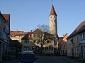
The landmark of the city, the 45 m high city tower

lock

Evangelical town church


View from the valley to the old town

Coat of arms on the town hall

Aerial photo on information board


Culture and sights
Buildings


In the historic center of Kirchberg, which as a whole plant is a listed building, many monuments have been preserved.
- Kirchberg Castle , former residential palace of the Princes of Hohenlohe-Kirchberg
- Evangelical town church from 1731 with interior decoration in the style of Art Deco
- City tower from 1400
- City gate from 1774
- Granary from 1490
- Sandelsches Museum (City Museum) in the building of the Latin School from 1748
- Five-bay stone arch bridge over the Jagst.
- Art Nouveau church (Evangelical parish church) in the Gaggstatt district, built in 1904 by Theodor Fischer .
- Evangelical parish church St. Stephanus in the Lendsiedel district with baroque organ (1701)
- Romanesque castle chapel in the Lobenhausen district
- Lobenhausen Castle in the Lobenhausen district
- Nikolauskirche in the Mistlau district, with Gothic wall paintings
- Hornberg Castle in the Hornberg district
landscape
- Old hunting loop near Lobenhausen. The castle ruins are on the Umlaufberg.
- Old hunting loop southeast of Mistlau. On the Umlaufberg and on the nearby Kropfberg to the north of it old quarries with exposed Haßmersheim layers.
- Alte Jagstschlinge immediately east of the Kirchberger Talsteige , the Sophienberg is the associated Umlaufberg.
Events / markets
- City holiday / February market, on the 4th Saturday in February
- Book market, the third Saturday in June
- Hofgarten Festival, on the 3rd weekend in July
- Christmas market on the 2nd weekend in Advent
traffic
Kirchberg is on the A 6 and has its own junction. The distance to the district town Schwäbisch Hall is about 25 km, to Crailsheim it is 12 km. Bus routes connect Kirchberg with Schwäbisch Hall, Crailsheim, Rot am See and Gerabronn as well as some nearby villages and hamlets.
education
Kindergartens
In Kirchberg there are three municipal kindergartens (in Kirchberg, Gaggstatt and Lendsiedel), a Protestant kindergarten and a Waldorf kindergarten .
schools
- August-Ludwig-Schlözer-Schule Kirchberg, elementary, secondary and secondary school
- Castle school , state-recognized high school with boarding school
- Kirchberg Bible School in the Hornberg district
- Johannes Gutenberg School, special needs school in the Gaggstatt district
Personalities
sons and daughters of the town
- August Ludwig von Schlözer (1735–1809), historian, educator and statistician (born in Gaggstatt)
- Christian Friedrich Karl zu Hohenlohe (1729–1819), Prince of Hohenlohe-Kirchberg, hereditary marshal and nobleman
- Friedrich Wilhelm zu Hohenlohe-Kirchberg (1732–1796), Imperial Feldzeugmeister
- Karl Friedrich Ludwig zu Hohenlohe (1780–1861), Wuerttemberg lieutenant general, Prince of Hohenlohe-Kirchberg, marshal of the hereditary kingdom and nobleman
- Sigmund Gundelfinger (1846–1910), professor of mathematics in Darmstadt, father of Friedrich Gundolf
- Friedrich Gustav Jaeger (1895–1944), officer, resistance fighter in World War II
- Georg Harro Schaeff-Scheefen (1903–1984), writer and historian
- Helmut Prassler (1923–1987), politician (CDU), Member of the Bundestag (born in Gaggstatt)
Individual evidence
- ↑ State Statistical Office Baden-Württemberg - Population by nationality and gender on December 31, 2018 (CSV file) ( help on this ).
- ↑ Main statute of the city of Kirchberg an der Jagst of September 13, 2004 ( Memento of the original of December 15, 2007 in the Internet Archive ) Info: The archive link was inserted automatically and has not yet been checked. Please check the original and archive link according to the instructions and then remove this notice. (PDF; 103 kB)
- ↑ On the topographic map 1: 25,000 (TK25) as the former Hetzelhof between the Streitwald and the north-western city limits, italicized backwards, today in the Lendsiedel district.
- ↑ The TK25 shows the (forward italic) trade name Ödisweiler to the southwest of the Gaggstadt – Weckelweiler road .
- ↑ The real estate cadastre at the State Agency for the Environment Baden-Württemberg (LUBW) ( information ) shows a ruin of Alte Sulz above the Kirchberg valley settlement to the right of the Jagst on the spur of the Steinbach valley on the border with Hornberg .
- ↑ The real estate cadastre at the State Institute for the Environment Baden-Württemberg (LUBW) ( references ) has a common name Äspich in the Lendsiedler district north of Herboldshausen along the upper Herboldhäuser Bach . A source branch of the Steinbach , which flows out at Kornberg , is called Esbach , but lies on the (today?) District of Gaggstatt.
- ↑ The real estate register to State Institute for Environmental Baden-Württemberg (LUBW) ( Notes ) of the Kirchberger junction designate about 500 m northeast on the A 6 is a corridor area to the north of a field oak with Geisshof , bathtub of the name Geißäcker and Geißholz adjoin.
- ^ The state of Baden-Württemberg. Official description by district and municipality. Volume IV: Stuttgart district, Franconian and East Württemberg regional associations. Kohlhammer, Stuttgart 1980, ISBN 3-17-005708-1 . Pp. 513-520
- ↑ On the TK25 former Wasserschl. in reverse encoding.
- ↑ State Statistical Office, area since 1988 according to actual use for Kirchberg an der Jagst.
- ↑ Mattern, Das Jagsttal ... , p. 45.
- ↑ Archived copy ( memento of the original from April 4, 2017 in the Internet Archive ) Info: The archive link was inserted automatically and has not yet been checked. Please check the original and archive link according to the instructions and then remove this notice.
- ^ Federal Statistical Office (ed.): Historical municipality directory for the Federal Republic of Germany. Name, border and key number changes in municipalities, counties and administrative districts from May 27, 1970 to December 31, 1982 . W. Kohlhammer, Stuttgart / Mainz 1983, ISBN 3-17-003263-1 , p. 448 and 468 .
- ↑ http://www.weissensee.de/fileadmin/weissensee-de/amtsblatt/2009-12.pdf ( page no longer available , search in web archives ) Info: The link was automatically marked as defective. Please check the link according to the instructions and then remove this notice.
- ↑ Data from Kirchberg / Jagst ( Memento of the original from April 16, 2010 in the Internet Archive ) Info: The archive link was inserted automatically and has not yet been checked. Please check the original and archive link according to the instructions and then remove this notice.
- ↑ Monument conservation value plans for the entire facilities in Kirchberg / Jagst, Langenburg, Schrozberg-Bartenstein (Schwäbisch Hall district) and Weikersheim (Main-Tauber district): Official handover of the value plans on January 28 and 29, 2009 in the town halls ( Memento from August 11, 2009 in the Internet Archive ). Press release of the regional council of Stuttgart from January 26, 2009 (accessed on February 1, 2009) (on archive.is)
- ^ Fridolin Rimmele: Professor Theodor Fischer's works in Swabia . In: Zentralblatt der Bauverwaltung , Vol. XXVI, No. 93 (November 17, 1906), urn : nbn: de: kobv: 109-opus-40150 , pp. 592-594.
- ↑ For more information on the bus routes serving Kirchberg, see the timetable for the Schwäbisch Hall roundabout at www.kreisverkehr-sha.de .
literature
- Topographic map 1: 25,000 Baden-Württemberg, as single sheet No. 6725 Gerabronn, No. 6726 Rot am See, No. 6825 Ilshofen and No. 6826 Crailsheim
- Hans Mattern: The Jagst Valley from Crailsheim to Dörzbach . Baier BPB Verlag, Crailsheim 1995, ISBN 3-929233-04-5 .
- Hans Dieter Haller: Kirchberg - black on white, Verlag Kirchberger Fenster 2003
- Hans Dieter Haller: Kirchberg an der Jagst - A painter's place, Stuttgart 2015, 2nd edition 2017
Web links
- Map of the urban area of Kirchberg an der Jagst on: State Institute for the Environment Baden-Württemberg (LUBW) ( information )
- Map of the city of Kirchberg an der Jagst on: Geoportal Baden-Württemberg ( information )
- Theodor Sandel: Kirchberg an der Jagst, Ed. G. Harro Schaeff-Scheefen, Nuremberg 1936

Blaufelden | Braunsbach | Bühlertann | Bühlerzell | Crailsheim | Fichtenau | Fichtenberg | Frankenhardt | Gaildorf | Gerabronn | Ilshofen | Kirchberg an der Jagst | Kreßberg | Langenburg | Mainhardt | Michelbach an der Bilz | Michelfeld | Oberrot | Obersontheim | Rose garden | Red at the lake | Satteldorf | Schrozberg | Schwäbisch Hall | Stimpfach | Sulzbach-Laufen | Untermünkheim | Vellberg | Wallhausen | Wolpertshausen