
Hargarten (Eifel)
| coat of arms | Germany map | |
|---|---|---|

|
Coordinates: 50 ° 6 ' N , 6 ° 24' E |
|
| Basic data | ||
| State : | Rhineland-Palatinate | |
| County : | Eifel district Bitburg-Prüm | |
| Association municipality : | Arzfeld | |
| Height : | 520 m above sea level NHN | |
| Area : | 2 km 2 | |
| Residents: | 97 (Dec. 31, 2019) | |
| Population density : | 49 inhabitants per km 2 | |
| Postal code : | 54649 | |
| Area code : | 06554 | |
| License plate : | BIT, PRÜ | |
| Community key : | 07 2 32 233 | |
| Association administration address: | Luxemburger Strasse 6 54687 Arzfeld |
|
| Website : | ||
| Local Mayor : | Ulrich Kockelmann | |
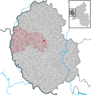
| Location of the local community Hargarten in the Eifel district Bitburg-Prüm | ||
  |
||

Hargarten is a municipality in the Eifelkreis Bitburg-Prüm in Rhineland-Palatinate . It belongs to the community of Arzfeld .
geography
The place is in the west of the Eifel , only a few kilometers east of the state borders with Luxembourg and Belgium .
The Sonnenhof residential area and a few houses in the Gesotz hamlet also belong to Hargarten .
66.1% of the municipal area is used for agriculture, 22.5% consists of forest (as of 2018).
Neighboring communities are Lascheid in the north, Feuerscheid in the west, Plütscheid in the south, and Lambertsberg in the west.
history
Until the end of the 18th century, the place belonged to the Pronsfeld condominium , which was under the joint sovereignty of the Electorate of Trier and the Duchy of Luxembourg . After the region was annexed by French revolutionary troops , Hargarten was assigned to the canton of Arzfeld in the department of forests in 1795. As a result of the resolutions passed at the Congress of Vienna , the area, and with it Hargarten, was awarded to the Kingdom of Prussia in 1815. Under the Prussian administration, the community came Hargarten 1816 to the recently completed Circle Prüm in Trier . It belonged to the mayor's office in Waxweiler .
Population development
The development of the population of the municipality of Hargarten, the values from 1871 to 1987 are based on censuses:
|
|
politics
Municipal council
The municipal council in Hargarten consists of six council members who were elected by a majority vote in the local elections on May 26, 2019 , and the honorary local mayor as chairman.
coat of arms
|
|
Blazon : "Square of red with a silver reel and a golden ear and silver with a golden inseminated blue flax flower and a green acorn."
The coat of arms was approved on July 21, 2005 by the district administration of the Bitburg-Prüm district. |
Economy and Infrastructure
Hargarten is today an agricultural community . Since 1971, when there were still 21 agricultural holdings, the utilized agricultural area has decreased from 183 ha to 133 ha (2018), which were cultivated by three holdings.
The place is about 3 km east of the junction Waxweiler / Schönecken of the federal highway 60 , which can be reached from Hargarten via the state road 33 .
Web links
- Internet presence of the Hargarten community
- Local community Hargarten on the webpage of the association community Arzfeld
- To search for cultural goods of the local community Hargarten in the database of cultural goods in the Trier region .
Individual evidence
- ↑ a b State Statistical Office of Rhineland-Palatinate - population status 2019, districts, municipalities, association communities ( help on this ).
- ↑ State Statistical Office Rhineland-Palatinate (ed.): Official directory of the municipalities and parts of the municipality. Status: January 2019 [ Version 2020 is available. ] . S. 95 (PDF; 3 MB).
- ↑ a b c State Statistical Office Rhineland-Palatinate: My village, my city. Retrieved January 4, 2020 .
- ^ Wilhelm Fabricius : Explanations of the historical atlas of the Rhine province, Volume 2: The map of 1789. Bonn, Hermann Behrend, 1898, p. 586
- ↑ Georg Bärsch : Description of the government district of Trier , Volume 2, Trier, Lintz, 1846, p. 24 ( Google Books )
- ^ The Regional Returning Officer Rhineland-Palatinate: Local elections 2019, city and municipal council elections.
- ↑ Description of coat of arms / justification. Hargarten parish, accessed on September 23, 2015 .
Arzfeld | Dackscheid | Dahnen | Daleiden | Dasburg | Eilscheid | Eschfeld | Euscheid | Großkampenberg | Hargarten | Harpelt | Herzfeld | Irrhausen | Itching | Kesfeld | Kickeshausen | Kinzenburg | Krautscheid | Lambertsberg | Lash oath | Lauperath | Leidenborn | Lichtenborn | Lierfeld | Lünebach | Lützkampen | Manderscheid | Mauel | Merlscheid | Niederpierscheid | Oberpierscheid | Olmscheid | Pintesfeld | Plütscheid | Price oath | Reiff | Reipeldingen | Roscheid | Sengerich | Sevenig (Our) | Strickscheid | Üttfeld | Waxweiler