
Inde (river)
| In the | ||
 |
||
| Data | ||
| Water code | EN : 2824 | |
| location | Belgium | |
| River system | Rhine | |
| Drain over | Rur → Maas → Hollands Diep → North Sea | |
| River basin district | Meuse | |
| source | at Raeren ( B ) 50 ° 39 ′ 12 ″ N , 6 ° 8 ′ 59 ″ E |
|
| Source height | approx. 395 m OP | |
| muzzle | near Jülich ( D ) in the Rur coordinates: 50 ° 53 '58 " N , 6 ° 21' 46" E 50 ° 53 '58 " N , 6 ° 21' 46" E |
|
| Mouth height | approx. 81 m above sea level NHN | |
| Height difference | approx. 314 m | |
| Bottom slope | approx. 5.8 ‰ | |
| length | 54.1 km | |
| Catchment area | 374.227 km² | |
| Drain at the mouth |
MNQ MQ |
954.7 l / s 4.885 m³ / s |
| Left tributaries | Saubach , Iterbach | |
| Right tributaries | Omerbach , Otterbach , Wehebach , Vichtbach | |
| Big cities | Aachen | |
| Medium-sized cities | Eschweiler , Jülich , Stolberg (Rhineland) | |
| Communities | Aldenhoven , Inden , Raeren | |
| Residents in the catchment area | 200,000 | |
 Diverted section of the Inde to reclamation area |
||


The Inde is a 54.1 km long left tributary of the Rur in Wallonia ( Belgium ) and North Rhine-Westphalia ( Germany ). Administratively it belongs to the Eifel-Rur water association .
Surname
The name of the Inde is first documented as Inda in a copy of the 13th / 14th century for the period 496 to 506 ( geographer of Ravenna 4, 24). Century of a copy of the 7th / 8th Century. The place name of the founding of the monastery of the imperial abbey Kornelimünster in the early 9th century, which was also first called Inda for short , until a Sancti Corneli ad Indam appears in 855 . The river name is of Celtic origin to a reconstructed nominal basic form * Indā = "the shining one" from a present tense stem from ancient Celtic * ind-o- = "to light up". The Celtic forms are derived from the primitive Indo-European present tense stem * h 2 i-nd h - the verb * h 2 éi̯d h = "to ignite", which survived in Middle High German as eit from the ancient Germanic * aidaz (flame, fire). Parallel names can be found in the South Tyrolean names of the village of San Candido in the upper Pustertal and the Drava tributary Sextenbach , whose original name is documented as India in the 9th century .
In local dialects such as in Eschweiler Platt , the river is called "Eng". The Inde is eponymous for the municipality of Inden in the Düren district and for the additional name "Indestadt" for Eschweiler; The Inda-Gymnasium in Kornelimünster and the sports club FC Inde Hahn are also named after the river. It is also eponymous for the Indeland project . In Stolberg, the Inde is also called the “Münsterbach” from the confluence of the Vicht upstream. In the Middle Ages, the imperial abbey Kornelimünster was the owner of extensive estates, the so-called Münsterländchen . In old maps the brook is referred to there as the Münsterbach.
geography
course
The Inde rises in the Hohes Venn-Eifel nature park about 1.5 km west-southwest of the Belgian-German border in the area of the Belgian municipality of Raeren . Its source lies between the Raeren core village in the northwest and the district of Petergensfeld in the southeast in the Perschei corridor at 395 m altitude. Several small streams flow into the Inde just below its source from a headwaters of around 3.5 km² in this corridor.
Already 2.4 kilometers from its source, the Inde meets the border from Wallonia to North Rhine-Westphalia at boundary stone 904 and forms the Belgian-German border for 1.3 kilometers of stream up to boundary stone 912. From then on, it characterizes the upper reaches of the Inde nature reserve Münsterwald and flows further in the districts Sief and Walheim through Aachen city area. It passes or affects the districts or localities Schmithof , Friesenrath , Walheim, Hahn , Kornelimünster , Niederforstbach , Krauthausen and Freund .
Thereafter, the Inde in the urban area of Stolberg passes or touches the districts or localities of Büsbach , Münsterbusch (nature reserve Muensterbusch between Hamm and Haumuehle (ACK-015)), Unterstolberg , Atsch , Velau and Steinfurt . Then it flows in the urban area of Eschweiler past Eschweiler-Aue , through the city center and through the Weisweiler district and crosses under the federal motorway 4 , which has had an “Inde” sign in each direction since the beginning of 1987. According to this, the Inde runs in the municipality of Inden through the district of Frenz and then between Kernort and Lamersdorf . It is then led past the Inden opencast mine to the west ; In doing so, it reaches the Eschweiler city again and passes the Lohn Memorial Chapel in the area of the former village of Lohn.
Then the Inde flows south past the Jülich district of Kirchberg , shortly afterwards to the east of it at 81 m above sea level. NHN in there from southeast zoom flowing Maas influx Roer to lead .
Catchment area and tributaries
The catchment area of the Inde is 374.227 km² and is located in the Belgian municipality of Raeren, the city region of Aachen and the district of Düren .
|
Stat. in km |
Surname | GKZ | location | Length in km |
EZG in km² |
|---|---|---|---|---|---|
| 51.258 | Prelate depths | 2824 112 | right | 2.355 | ? |
| 47,702 | Fobisbach | 2824 12 | right | 3,492 | ? |
| 47.09 | Kalkhäuschenbach | 2824 14 | right | 1,598 | ? |
| 43,333 | Bechheim Bach | 2824 16 | right | 2.993 | ? |
| 41.673 | Jammetsbach | 2824 18 | right | 2.763 | ? |
| 40.56 | Iterbach | 2824 2 | Left | 15,443 | 37.782 |
| 37.57 | Rollefbach | 2824 32 | Left | 4.056 | ? |
| 35,847 | Fox maul | 2824 332 | right | 1,233 | ? |
| 34.846 | Ellerbach or Flachsbach | 2824 34 | right | 1,947 | ? |
| 32,428 | Beech tail 1 | 2824 36 | Left | 1,747 | ? |
| 31,586 | Scheidsief | 2824 38 | Left | 1.014 | ? |
| 30.645 | Geisbergsief | 2824 392 | Left | 1.062 | ? |
| 28.254 | Vichtbach | 2824 4 | right | 22.972 | 104.083 |
| 27.713 | Saubach | 2824 52 | Left | 7.354 | 16,698 |
| 24.984 | Fuchsbach | 28245 94 | Left | 2.144 | ? |
| 24.195 | Finkelsbach | 28245 96 | Left | 1.119 | ? |
| 20.054 | Omerbach | 2824 6 | right | 11,047 | 21,876 |
| 18,047 | Otterbach | 2824 72 | right | 4.202 | ? |
| 18,961 | Mühlengraben | 2824 732 | Left | 0.729 | ? |
| 17.883 | Holzheimer Graben | 2824 74 | right | 3,692 | ? |
| 16,553 | Dürwisser Graben | 2824 76 | Left | 3.93 | ? |
| 15.278 | Frenzer Fliess | 2824 78 | right | 2.166 | ? |
| 13.56 | Wehebach | 2824 8 | right | 25,706 | 68.423 |
history
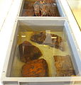
West of Büsbach and Münsterbusch , in the Atsch , today's Stolberg (near Aachen) and in the area of the former imperial abbey Kornelimünster , the waters of the Inde drove several mills - including copper mills , the Elgermühle, Bocksmühle, Haumühle and the Hamm -Mühle and the Bushmill, the buildings of which are still preserved. In 2009 archaeologists discovered the remains of an approximately 2000 year old watermill on an oxbow lake in the Düren district , which is the oldest structure of its kind north of the Alps . The finds are two large wooden axle boxes, shovel-like objects and millstones. With found in mill near fibulas a date should the findings be made possible because they were subject to a fashionable change. Based on their research, the archaeologists assume that the mill operators are locals who have adopted Roman technology.

Millstones of the water mill
Axle bearings and wooden shovels
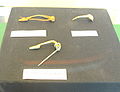
Brooches (similar to the shape of safety pins)


pollution
By introduction of leachate from an old industrial halde of Kali Chemie and from the so-called Vegla-polders the Inde from Stolberg, among others with dilute acid very dirty. Since September 19, 2005 is a public service contract that, according to the humic acid collected leachate to the polders, via a feed line to the premises of the Stolberg company " Saint-Gobain Glass continued," and from there to the treatment plant Stolberg Steinfurt to be performed . This project is expected to cost 10 million euros. It must be operated for at least 30 years.
The potash dump of the chemical factory Rhenania - it is located in the Stolberg city area opposite the Vegla polder - is the largest contaminated site in the Aachen city region .
In 2007, a treatment plant for seepage water from the Vegla polders was put into operation on the northern company premises of "Saint-Gobain Glass"; the discharges into the Inde have been cleaner since then.
In 2018, increased dioxin levels were measured at Inde and Münsterbach.
New river bed
Since 1996, as part of the rehabilitation of the former Inden opencast mine, work has started on creating a new river bed for the Inde between the villages of Lamersdorf and Kirchberg. Due to the necessities of open-cast mining, the new Inde was created in the immediate outskirts of the ongoing open-cast lignite mining. In future, the Inde will flow in a semicircular arc to the west near Neu-Lohn . The new river bed was designed with special ecological considerations: Instead of the previously 5 km straightened river, the length of the section is now 12 km. The floodplain is up to 300 m wide. According to the specifications of the planning approval from 1998, the body of water should develop further dynamically within the floodplain. After the trial operation began on April 20, 2005, the water flow was gradually increased. The complete flooding took place on September 2, 2005. The old bed of the Inde between Lamersdorf and Kirchberg was removed just a few weeks later as the Inden II opencast mine progressed .
Although fish were fished and moved on behalf of RWE Power before the old river bed was drained, the fishery overseer for the Düren district reported "over 10,000 fish, some of which were large", which died as a result of the drainage.
Impressions

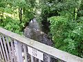
Falkenbach Bridge over the Inde, also called Falkenbach here
Inde at the Elgermühle near Stolberg
Inde in the Gedautal , locally named Münsterbach

Inde in the city center of Eschweiler

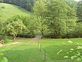
Indeauen between Nothberg and Weisweiler

Inde at Weisweiler

New course of the river with a view of Aldenhoven

The Rur u. a. with the inde course


Individual evidence
- ↑ a b Géoportail de la Wallonie , Service public de Wallonie (SPW) ( notes )
- ↑ a b Amsterdamer Ebene ( Normaal Amsterdams Peil ; NAP), based on a bearing mark in Amsterdam
- ↑ a b c d e f g h Topographical Information Management, Cologne District Government, Department GEObasis NRW ( information )
- ↑ a b German basic map 1: 5000
- ↑ ELWAS card
- ^ Albrecht Greule : German water names book. Etymology of the water body names and the associated area, settlement and field names. Walter de Gruyter, Berlin / Boston 2014, ISBN 978-3-11-019039-7 , pp. 242 ( available for a fee from de Gruyter Online).
- ↑ Historical map: Kornelimünster 1789 Fabricius , Inde mapped as Münsterbach, on commons.wikimedia.org
- ↑ Water directory of the State Office for Nature, Environment and Consumer Protection NRW 2010 (XLS; 4.67 MB) ( Notes )
- ↑ The mill in the Hamm , on stolberg-abc.de
- ↑ Sensational find: watermill from the Indetal 2000 years old , from August 25, 2009, on rheinischer-fischereiverband.de
- ↑ Ancient watermill excavated , August 25, 2009, on n-tv.de.
- ↑ a b Jürgen Lange: Potash heap is given a dense profile. In: Aachener Zeitung . October 18, 2011, accessed December 15, 2012 .
- ^ [1] Aachener Zeitung: increased dioxin values at Inde / Münsterbach
Web links
- The Inde , at the Eifel-Rur water association , on wver.de
- More life for Inde and Co. , on rur.nrw.de (PDF; 3 MB)