
Kakadu National Park
| Kakadu National Park | |||
|---|---|---|---|
 |
|||
|
|||
| Location: | Northern Territory , Australia | ||
| Specialty: | Rock carvings, flora and fauna, wetlands, rock formations and gorges | ||
| Next city: | Jabiru - Darwin | ||
| Surface: | 19,804 km² | ||
| Founding: | 1981 | ||
| Visitors: | 226,000 (2007) | ||

| Kakadu National Park | |
|---|---|
|
UNESCO world heritage |
|
| National territory: |
|
| Type: | Culture / nature |
| Criteria : | (i) (vi) (vii) (ix) (x) |
| Surface: | 1,980,994.92 ha |
| Reference No .: | 147quater |
| UNESCO region : | Asia and Pacific |
| History of enrollment | |
| Enrollment: | 1981 ( session 5 ) |
| Extension: | 1987, 1992, 2011 |
The Kakadu National Park (English Kakadu National Park ) is 171 kilometers east of the city of Darwin in the Australian federal territory of the Northern Territory . The park is one of the most beautiful national parks in Australia due to its unique flora and fauna. It is located in the Alligator Rivers region of the Northern Territory of Australia. It covers an area of approximately 19,804 square kilometers and extends almost 200 kilometers from north to south and over 100 kilometers from east to west.
The Kakadu National Park has been included in the UNESCO list as both a World Heritage Site and a World Heritage Site because of its outstanding natural and cultural value . The park contains one of the most beautiful and extensive collections of rock art in the world - an indication of how long the connection between the indigenous people and the area has been. There are great landscapes in the park, from the wild, rough sandstone flanks of the high plateau to the extensive forest areas and extensive wetlands. The national park also protects the entire catchment area of a large subtropical river, the South Alligator River, and examples of all habitat species in the top end of Australia.
The park is a cultural landscape that, according to the belief of the indigenous people, gave shape to their spiritual ancestors in the time of creation ("Creation Era"): They wandered through the country and created the landforms, plants, animals and Bininj / Mungguy (indigenous people) on their journey. They taught the Bininj / Mungguy how to live and how to cultivate the land. The park is now jointly managed by its traditional owners, the Aborigines, and the employees of Parks Australia. They strive to protect the interests of the traditional owners, to preserve the cultural heritage of the park and to encourage visitors to the park to make use of its offers with respect for nature and the tradition of the indigenous people.
Facts
- Foundation: 1981
- Size: 19,804 km²
- Population: before the arrival of the Europeans, probably around 2000, today around 500
- Climate: Average temperature 34 ° C, 90 percent of precipitation from November to April
- Natural resources: The area of the national park contains uranium which is among the richest in the world (such as the Ranger uranium mine ).
- Main town: Jabiru with an airport.
- from 1971: uranium mining by mining companies
- 1978: Return of the land to the indigenous people, the Buntji clan of the Gaagudju tribe
- 1981: Buntji clan leases land to the government; Establishment of the national park
- 1992: The Kakadu National Park is declared a “Heritage of Humanity” by UNESCO
- 2002: After years of protests, the mining company Rio Tinto Group , the uranium mining at Jabiluka - mine one.
The Kakadu National Park comprises four river systems:
- East Alligator River
- West Alligator River
- Wildman River
- South Alligator River (the entire catchment area of which is within the park)
The following main landscape forms are represented:
- Inlets and Watts
- Floodplains
- Billabongs
- Plains
- the stony mountains and its foothills
- the southern mountains and valleys
The Kakadu National Park has a unique flora and fauna. It includes more than 280 species of birds, more than 60 species of mammals, more than 50 species of freshwater fish and more than 10,000 species of insects and over 1,600 species of plants.
history
introduction
.jpg)

The name "Kakadu" originated from the incorrect pronunciation of the word "Gaagudju", which is the name of the Aboriginal language spoken in the northern part of the park.
Aboriginal people have inhabited the Kakadu National Park area for likely 50,000 years. Therefore, the park has important cultural relics. In total, there are more than 5,000 art sites that have been built over thousands of years and have been settled for at least 20,000 years. A stone ax found in eastern Arnhem Land has been dated to an age of 35,500 years, it is the oldest artifact in the region and the oldest tool of its kind in the world.

The cultural and ecological importance of the Kakadu National Park was recognized with the listing of the park as a UNESCO World Heritage Site on the World Heritage List. This listing took place in three phases: phase 1 in 1981, phase 2 in 1987 and the entire park in 1992.
About half of the Kakadu National Park area is Aboriginal land, covered by the Aboriginal Land Rights (Northern Territory) Act of 1976. Much of the rest of the land is also claimed by the Aborigines, but has not yet been assigned to them. The Aborigines have leased their areas to the Director of National Parks to manage them as a national park under the Environment Protection and Biodiversity Conservation Act of 1999.
The Aborigines who are the current owners of the park are descendants of various groups in the park area and have a strong sense of belonging to their land. Although their lifestyles have changed dramatically over the past century, their traditional views and beliefs are still very important to them.
Establishment of the park

Kakadu National Park was established at a time when the Aborigines were keen to be recognized as a national park. Already in 1965 an application was made for the recognition of the area of the Alligator River , but it was not until 1978 that the Australian government united the different regions that make up the park today.
Kakadu National Park was recognized under the National Parks and Wildlife Conservation Act 1975 (NPWC Act) in three phases between 1979 and 1991, with the NPWC Act 2000 being replaced by the EPBC Act. At each stage, Aboriginal rights to the land were recognized and part of that land was leased to the director of the national parks. The contract for the first phase was signed on April 5, 1979, for the second phase on February 28, 1984.
In June 1987 a land claim was made by the former Goodparla and Gimbat lease, which was then recognized in the third phase. The area known as Gimbat Resumption and The Waterfall Creek Reserve was only later added to this claim. At that time there was an extensive debate as to whether the mining of uranium at Guratba (CoronationHill) in the national park should be allowed. The Australian government respected the wishes of the Aborigines and no mine in Guratba was approved. In 1996 in phase 3, apart from the former Goodparla lease, the land was given to the Gunlom Aborigine Land Trust and leased to the Director of National Parks as part of the Kakadu National Park.
Explorer
The Chinese , Malay and Portuguese all describe themselves as the first explorers of the Australian north coast. However, the first written evidence of a discovery is only documented in 1623 by the Dutchman Jan Carstensz . The next documented explorer is Abel Tasman , who toured this coast in 1644. He was the first European to have any known contact with the native Aborigines. Almost a century later, in 1802/03, Matthew Flinders toured the Gulf of Carpentaria.
Philip Parker King , an English navigator, toured the Gulf between 1818 and 1822. During this time he named the three Alligator Rivers after the great saltwater crocodiles that he mistook to be alligators . Ludwig Leichhardt was the first European to explore the Kakadu region from land on his journey from Moreton Bay in Queensland to Port Essington in the Northern Territory in 1845 . He followed Jim Jim Creek from Arnhem Land , then traveled north along the South Alligator and East Alligator.

In 1862, John McDouall Stuart traveled along the southwestern border of what is now Kakadu National Park, but saw no locals at that time. In 1866, John McKinlay's next expedition ended in fiasco after six months. This explorer tried to travel the region from the south and got as far as the East Alligator River. The rising rivers and general conditions became so bad due to the rainy season that this expedition had to be canceled.
The first non-Aboriginal people who were demonstrably in close contact with the locals were the Macassans of Sulawesi and other parts of Indonesia . At the end of the 17th century they began to visit this region regularly during the rainy season. The main goal of these trips was the harvest of trepang ( sea cucumber ), the catching of turtles , the collecting of pearls and other things that are valuable in their home country. The Aborigines helped them harvest and fish and traded their own stocks. Although there is no direct evidence that the Macassans spent time on land, influences of their culture on the Aborigines can be seen in the area of Kakadu National Park. Among the artifacts from archaeological digs in the park are glass and metal fragments that are believed to have come from Indonesia, either directly or through a trade with the Aborigines.
The British settled on the northern coast of Australia at the beginning of the 19th century: Fort Dundas on Melville Island in 1824, Fort Wellington in Raffles Bay in 1829 and the Victoria Settlement (Port Essington) on the Coburg Peninsula in 1838. These settlements were in Abandoned over time due to various reasons such as lack of water, illness or extreme isolation. The influence of these settlers on the Aborigines is difficult to assess. What is certain is that Aboriginal labor was used to build the settlements and the risk of new diseases for the locals increased.
Buffalo hunters

The "Buffalos" ( water buffalo ) had a great influence on the Kakadu region. By 1880 there were so many buffalo in the area that the animals' horns began to be used commercially. This industry began on the Adelaide River, near Darwin, and then moved east to the Mary and Alligator Rivers regions. The buffalo were mainly hunted and skinned in the dry season between June and September when they were at the remaining water holes. During the rainy season , the buffalo hunt was difficult due to the subsoil and the skins were moldy. The buffalo industry provided jobs for many Aboriginal people during the dry season.
Missionaries
Missionaries also had a strong influence on the Aborigines in the Alligator River region; many of them were tutored by the missionaries in their youth. Two missions were established in the region early in the last century. The Kapalga Native Industrial Mission was founded on the South Alligator River in 1899, but only lasted four years. The Oenpelli Mission was founded in 1925 when the Church of England accepted an offer from the Northern Territory government. It was operated as a farm for 50 years. The extent of the missionaries' influence on the Aborigines is still debated today. Some historians and anthropologists claimed that the missionaries tried to "civilize" the Aborigines, forcing them to adopt a new lifestyle, language, religion, and ceremony. Others, however, stress that the missionaries cared for the well-being of the Aborigines above all else, at a time when these natives were not yet recognized by Australian society.
farmer

Agriculture got off to a hesitant start in the top end as the Victoria River and Barkly Tableland areas offered better conditions. In the southern part of the Kakadu National Park, the area around Goodparla and Gimbat was claimed by the three farmers Roderick, Travers and Sergison in mid-1870, but this leased land then went to different owners who gave up management for various reasons. In 1987 both stations were taken over by the Commonwealth and are now administered as part of the park.
A sawmill at the Nourlangie Camp was initially operated by the Chinese , probably even before the First World War . After the Second World War, various smaller companies established themselves in the field of dingo hunting, buffalo hunting, hunting shooting and tourism. The Nourlangie Camp was used as a sawmill until the 1950s and later converted into a safari camp when the forest was dwindling. A little later, similar camps were set up in Patonga and Muirella Park. Tourists were flown in to hunt buffalo or crocodiles or to fish.
The crocodile hunt benefited above all from the knowledge and skills of the Aborigines. They imitated the opening of a wallaby's tail, so that the crocodiles were attracted and could be more easily shot by the hunters. The crocodile's skins were used for leather products. With the development of spotlight technology at night, the help of Aborigines was less used. Freshwater crocodiles have been under nature protection since 1964.
Mines

The first discoveries of various minerals in the Top End took place during the construction of the Trans-Australian Telegraph Line between 1870 and 1872 in the Pine Creek - Adelaide River area. A series of minor mining booms followed, but it wasn't until the North Australia Railway line started supplying the mining camps that Burrundie and Pine Creek became permanent camps. The newly established camps resulted in many Aborigines leaving the area. Aborigines themselves did not work in the mines, but the mines gave them access to alcohol and other drugs.
In the vicinity of Imarlkba ( Barramundi Creek ) and Mundogie Hill, some smaller gold mines were built around 1920. More followed in 1930 near Moline (also called Eureka and Northern Hercules mine) south of the park. Some Aborigines were also employed in these mines.
The greatest impact, however, was the 1953 discovery of uranium in the southern Alligator River valley. Thirteen smaller but plentiful mines operated in the following years, with most of the workers (150) working there in 1957. No Aboriginal people were employed in these mines.
The next uranium deposits were discovered in Ranger, Jabiluka and Koongarra . The Commonwealth Government then submitted an official request to use this land in the Alligator Rivers region. This request, also known as Fox inquiry, suggested, among other things, that a service city should be established. Overall, the discovery of the uranium deposits had a major impact on the lives of the local Aborigines. The dismantling is still controversial today.
Seasons


Kakadu is located in the tropics, about 12 ° to 14 ° south of the equator . The climate is monsoons and is characterized by two seasons: the dry season and the rainy season .
Dry season (April to September)
During the dry season (from April / May to September) a dry south-easterly wind is predominant. The humidity is low and rain is rare. In Jabiru , the maximum average temperature in June / July is 32 ° C. In the early dry season, the land slowly dries up. Grass fires can often be seen lit by rangers and the traditional (Aboriginal) owners. As the season progresses, river beds and floodplains also dry up; the animals throng the year-round remaining wetlands, making this the best time of year to spot crocodiles, birds and other animals in the wild. The dry season is likely to be the most pleasant and popular season to visit the park.
“Build-Up” (the time before the onset of the monsoon rain)
During this time, the humidity increases more and more until the electrical voltage that has built up is discharged in the most severe storms, which also provide relief. During the “build up” (October to December) conditions can become very uncomfortable, with high temperatures and high humidity. Then the storms are very strong and this is also the best time of year for watching crocodiles and birds in the rivers and wetlands. During this time, more lightning strikes are registered in the Top End of Australia than anywhere else in the world. The maximum average temperature in October is 37.5 ° C.
Rainy season (December to March)
The rainy season from January to April is characterized by high temperatures and rain. Most of the monsoon rains form over South Asia and so cyclones arise during this time , which bring heavy rain with them. In Jabiru , the maximum average temperature in January is 33 ° C. Kakadu National Park's annual rainfall ranges from 1,565 mm in Jabiru to 1,300 mm in the Mary River region.
Visitors in the rainy season can experience the lively changes when, after the onset of monsoon rains, streams and river beds fill up and their water pours into the floodplain. The young shoots transform the eucalyptus forests into a sea of bright green. However, the humidity often rises uncomfortably high, accompanied by frequent rainfall. On the other hand, the waterfalls are most beautiful during this time, even if some can only be seen from the air, since access to several park areas is severely restricted during this time.
Most non-Aborigines only differentiate the seasons into dry and rainy seasons. The Aborigines Bininj / Mungguy, on the other hand, distinguish six seasons in the Kakadu region:
- Gunumeleng - mid-October to late December, pre-monsoon storm season with hot weather and thunderstorms in the afternoon
- Gudjewg - from January to March, monsoon season with thunderstorms, heavy rains, floods, heat and high humidity, generally a strong growth phase for flora and fauna
- Banggerreng - April: the floods are receding, stormy and windy weather that weighs down the grass.
- Yegge - May to mid-June: relatively cool with low humidity. It was during this period that the Aborigines traditionally began burning down the undergrowth to support new plant growth and clean up the land
- Wurrgeng - mid-June to mid-August: cool weather, low humidity, the plains are drying up, the rivers are drying up.
- Cooing - mid-August to mid-October: hot, dry weather, further decline in billabongs
flora


The flora of Kakadu National Park is among the richest in the Northern Territories, with more than 1700 plant species that reflect the geological and ecological diversity of the park. Kakadu is also considered to be one of the world's weed-poorest national parks.
Each of the different geological landscapes has its own specialized flora . The landscape, which is described as a stony landscape, for example, has special types of grass that survive even in extreme heat and in long dry periods followed by heavy rainfall.
Rainforests are often found in the rather cool gorges. Many endemic plant species can be found in the southern mountains and valleys such as the Eucalyptus koolpinensis , which developed near the Jarrangbarnmi (Koolpin Gorge). The lowlands form a large part of the Kakadu National Park. It is overgrown with eucalyptus and various types of grass such as spear grass and various types of wild flowers. The plains, which are flooded for much of the year, are home to sedge and tree species such as the freshwater mangrove (itchy tree), screw trees ( pandanus ) and myrtle heather ( Melaleuca ). Water lilies , lotus flowers, and water lilies in blue, yellow, and white are also common. Some rare carnivorous plants such as rainbow plants , water hoses and sundew also have their home here. A wide variety of mangrove species can be found in the inlets and the tidal plains (39 of the 47 native mangrove species in the Northern Territory grow in Kakadu National Park), which also play a crucial role in stabilizing the coastline. Mangroves serve as breeding and feeding grounds for many different fish species such as the barramundi .
Between 1964 and 2004, an increase in woody plants was recorded both in the eucalyptus savanna areas and in the alluvial plains. The increasing buffalo populations in the park were seen as a possible explanation for this development. Recent research shows, however, that the buffalo play only a relatively minor role and that the greatest influence is likely to come from fire management and climate change.
fauna


The different habitats of the park are also home to many animal species, some of them specially adapted to individual habitats - endemic and others listed as endangered species . Due to the extreme climate, many animal species are nocturnal or only active at a certain time of the year.
There are around 60 different species of mammals in Kakadu National Park. Most of them are found in the forests and plains and are rather nocturnal. Others like the wallabies and kangaroos (8 species in total) can also be seen in the colder hours of the day. Some of the more common species include dingoes , antelope kangaroos , black mountain kangaroos , agile wallabies and short-eared rock kangaroos , miniature sacred martens , large brush-tailed pouches , large short-nosed pouches , black-footed tree rats and black fruit bats . Dugongs are found in the coastal waters .
The different landscapes of the national park attract thousands of birds, especially in the rainy season . About 280 species of birds live in Kakadu and thus around a third of all bird species in all of Australia . The best-known of these are the African pelican , giant stork , white-bellied sea eagle and cleft-footed goose .
To date, 117 species of reptiles have been recorded in the cockatoo. Since they are cold-blooded , the warmth of the sun is vital for them to regulate their body temperature. But that doesn't mean that all reptiles are only diurnal; on the contrary, some species of snakes tend to be nocturnal.

There are two different species of crocodile in Kakadu National Park : the freshwater crocodile ( Crocodylus johnstonii ) and the estuarine crocodile or saltwater crocodile ( Crocodylus porosus ). Freshwater crocodiles are easy to identify by their conspicuously narrow, pointed snout and the four bony arches just behind the head, which saltwater crocodiles do not have. The maximum size of these animals is 3 meters, whereas saltwater crocodiles can grow up to 6 meters. This makes crocodiles one of the most notorious animals in Kakadu National Park, known not least from the film Crocodile Dundee - A Crocodile to Kiss (1986), which was partially shot in Kakadu National Park.
In the Kakadu National Park there are 25 species of frogs that are extremely well adapted to the extreme climate. Some of them are only active in the rainy season. At the beginning of the rainy season , when the waterholes (billabong) fill with water, the nights are filled with frog croaking from, for example, Northern bullfrogs and various species of Australian southern frogs . Not all frog species live in the wetlands; many are also found in the forest areas.
So far 53 different freshwater fish species have been identified in the Kakadu National Park; eight of them can only be found in a limited area. There are 32 species in the Magela Creek System, compared to only 27 species in the Murray River . There are many species of human introduced fish in Australia; but so far none have been found in the park. A common freshwater fish is the barramundi .
Although there are more than 10,000 different types of insects in the park , these animals are often overlooked by visitors. Among the insect species in the park include grasshoppers , beetles , flies , termites , butterflies and moths, bees , wasps , ants , dragonflies and damselflies , caddis flies , mosquitoes and mayflies .
The most impressive insects are probably the termites with their huge termite mounds, which are located in the southern part of the park. The Leichhardt's grasshopper in its orange, blue and black colors is one of the most famous insects in the Kakadu National Park. It is also found in Arnhem Land and Gregory National Park .
Introduced species
Kakadu National Park is home to a feral population of the water buffalo introduced from Asia . The animals were introduced here in the mid-19th century and kept in check by local hunters until the 1950s. In 1988 the number of animals living here was 20,000. Through their eating and puddling behavior, they had a lasting effect on their habitat. Native animal species such as crocodiles and barramundis decreased in their numbers; the habitat, especially for native water birds, has been permanently restricted. The number of water buffalo was reduced to 250 animals in 1996 through a rigorous kill program.
However, it is not yet clear what influence the buffalo actually have on the vegetation. In particular, fires, which the Aborigines used to deliberately set, may have changed the original vegetation significantly. According to a study, a high buffalo population appears to lead to reduced woody growth within the alluvial plains, while buffalos in the eucalyptus savannahs are said to favor the spread of woody trees. The explanation for this could be bushfires, which become less large due to the grazing of the undergrowth in high buffalo populations. In contrast, another study comes to the conclusion that the influence of the buffalo on the distribution of woody plants in the national park is relatively small. According to this, other causes such as fire or climatic changes would be responsible for the general spread of woody plants. In addition, a complex, non-linear relationship between buffalo and vegetation is conceivable. For example, very high buffalo populations could possibly push back woody trees by trampling down young trees and eating off the saplings, while the complete absence of buffalo could leave enough undergrowth for large fires, in which woody trees often burn. Accordingly, low buffalo populations are perhaps most likely to favor the spread of woody plants. Another invasive species that could threaten the ecosystem is the cane toad introduced to Australia in 1935 .
Landforms


There are six different landforms in Kakadu National Park: the Arnhem Land Plateau, also known as sandstone habitats , the estuaries and estuaries, the flood plains and billabongs, the lowland savannah , the southern mountain ranges and valleys. Each of these landscape forms has its own habitats, which together contributed to the fact that the park was listed as a World Heritage Site by UNESCO .
It is believed that Kakadu was largely a shallow lake or sea about 140 million years ago . The rock formations that stand out today formed a cliff and behind it the Arnhem Land Plateau formed as a flat land a little higher than sea level . Today these former cliffs rise up to 330 m above the plateau and form a 500 km long line along the eastern border of the park all the way to Arnhem Land. This line varies from vertical cliffs like Jim Jim Falls to more step-like isolated cliffs in the north.


The rock formations of the plateau are made up of a network of ravines and crevices. The upper levels of the plateau are very dry and water dries away quickly. There is little real earth that is then rather sparsely overgrown. In the course of time, niches developed in small groups of forests.
Tropical rainforests formed in the gorges and are fed by the water flowing down from the rocks. This created unique microhabitats for different animal and plant species. Many animal species survive the dry season only through these habitats. The main species of plant in these gorges is the Allosyncarpia ternata , a large tree that only grows in Kakadu National Park and Arnhem Land.
The foothills of the plateau separated over time and are characterized by heavy erosion . Some of these are also former islands of the sea that covered the Kakadu region. This type of landscape extends over large areas of the top end. It covers a total of about 70% of the park. The thickness of the breeding ground in this landscape is also only slight; the ground is often covered by laterites (bricks), some of which form a rock-like landscape.
During the rainy season , the water from the Arnhem Land Plateau flows into the lower plains and floods the rivers, streams and flood plains. With this water abundant nutrients are washed ashore and lead to a rich animal and plant life. In the dry season , water is only found in the rivers, streams and billabongs. The National Park's billabongs are listed (Ramsar Convention) for their rich biological potential.
The southern mountains and valleys take up a large part of the south of Kakadu National Park. The rock formations in this area were created by volcanic activity and are around 2500 million years old.
The coast of the park and the river systems are under the influence of ebb and flow , which extends up to 100 km into the country. This area is very different from the dry season to the rainy season . In the rainy season, this area is flooded by water that contains nutrient-rich silt, which is also washed into the sea and contributes to the characteristic muddy water in this time in the coastal area.
Many bird species find plenty of food in this area, which makes it attractive to ornithologists .
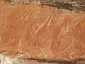
Aboriginal rock art
.jpg)
The art sites of the Kakadu National Park Ubirr , Nourlangie and Nanguluwur are internationally known as outstanding Aboriginal rock art. They are found in the rocks, rock overhangs and cave entrances, in areas that have been inhabited by Aborigines for millennia. The backgrounds and motifs of these paintings are different:
- Hunting scenes - animals were often depicted to guarantee the success of the hunt and to get to the spirit of the animals
- Religious reasons - some of the scenes represent ceremonies
- Stories and Teachings - stories related to the creators who gave shape to the world
- Sorcery and magic - paintings were used to influence events and the lives of certain people
- Depiction of heroes and their deeds - mainly ghosts from Dreamtime
- Fun - children's games and for practicing painting techniques
The first rock art was discovered by non-Aborigines in the early 19th century, of which the ethnologist Baldwin Spencer was the first in 1912. In the Kakadu National Park around 5000 paintings have been recorded so far, some galleries, some individual rock paintings. It is believed that this number will double until they are all included. Since the rock paintings are painted with natural, water-soluble colors, rain and the development of dust by visitors endanger the existence. One of the main tasks of the park rangers is therefore to preserve the paintings by laying drip gutters and diverting water rivers.
X-ray style nourlangie rock
barramundi fish
Nourlangie rock
kangaroo in x-ray style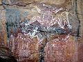
Nourlangie Rock
a group of ghosts at
Ubirr
“Mimi” spirit
Ubirr
Aborigini Rock Painting
Ubirr
Aboriginal Rock Art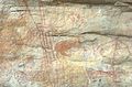
Nanguluwur
Wallaby drawing

.jpg)
.jpg)

.jpg)

Influence of man

The influence of humans, especially in the 19th and 20th centuries, was significant. The greatest damage was caused by the introduction of the water buffalo from Asia , as many fragile systems such as the billabong were almost irrevocably damaged. A large part of the buffalo was therefore released for hunting in the last century and the population thus reduced. Crocodile hunting has been banned in the area since 1972, although there are discussions today about releasing a small population for shooting because the number of crocodiles is too high and there is not enough food for the animals.
The mines are of course another human influence on the landscape, although there is currently only one operating mine. The companies are required to restore the area to its natural state after it has been dismantled.
Today tourism is one of the strongest influencing factors, as hundreds of thousands visit the park every year. For this purpose, an appropriate infrastructure was built, accommodation, roads, telecommunications systems and much more
Fire management

Fire is part of the landscape of the Kakadu National Park, especially in the vast grass and scrubland that is exposed to long periods of drought. The flora is adapted to the fire and some plants need these bushfires to reproduce because the seed pods only burst at high temperatures. Fire in general is less dangerous here than in the southern parts of Australia. Many trees are resistant to fire, other plants have a rapid regeneration phase.
Controlled burning is carried out in Kakadu National Park in coordination with the traditional owners, the Aborigines. This setting of fire has been practiced by the Aborigines for thousands of years, partly in relation to land management or hunting to lure the animals out. When the fire is out, the new young plants attract animals such as wallabies in particular . Eagles often circle almost directly over the fire to hunt small animals that want to escape the fire.
tourism

Kakadu National Park is one of the main attractions in the Northern Territory , attracting over 200,000 visitors annually (up from 202,000 in 2005). The landscape, the flora and fauna and the culture of the Aborigines arouse great interest. There are some beautiful waterfalls and canyons like Maguk , Gunlom , Twin Falls and Jim Jim Falls .
Kakadu National Park features some of the best-preserved Aboriginal rock art in Australia . Although there are innumerable paintings in the park, Nourlangie and Ubirr are the most famous and most visited. The best way to experience the diversity of animals is in places like Yellow Water Billabong, from Cooinda or Mamukala on a wildlife cruise or at Anbangbang Billabong . 30% of all Australian bird species can be found in the park, making it a magnet for many bird lovers.

Large estuarine crocodiles (also known as saltwater crocodiles) can be seen by visitors to the park in the wild, especially in the Yellow Water and East Alligator River . The film Crocodile Dundee was shot here. Swimming is prohibited in many parts of the park due to the risk of a crocodile attack. Safe swimming areas are signposted or can be requested from the visitor center.
The barramundi is a very popular fish among anglers in the national park. Fishing is allowed in the park, but hunting is not.
There are various types of accommodation in the park, from bush camping to 5-star hotels. Most are in Jabiru . The park can be explored independently by car or on a guided tour. Most roads are two-wheel drive but there are areas around the Twin and Jim Jim Falls and Gunlom that require an off-road vehicle. A well-known route is the so-called Nature's Way tourism drive, which leads from Darwin to Jabiru to Katherine and back to Darwin. It is about 900 km long.
Attractions


- The Bowali Visitor Center - An exhibition and video films provide an insight into the most important habitats in the park.
- Mamukala Wetland - A covered observation platform allows bird watching. You can hike around the wetland on extensive sidewalks.
- Warradjan Aboriginal Culture Center - Contains an exhibition and information on many aspects of the Aboriginal culture of the Kakadu area. Many exhibits were made available by Bininj (man / man here: name of the Aborigines of the area) of the Murrumbur clan. The center is named after Warradjan, the Papuan tortoise, whose shape is based on the architecture of the center.
- Yellow Water - A lively changing wetland, in the rainy season a flooded body of water, it turns into a sanctuary for animals during the dry season.
- Maguk - A beautiful pond at the foot of a small waterfall.
- Gunlom Pond - You can view this waterfall from your foot or climb up and explore the rocky area above.
- Yurmikmik - Especially in the rainy season, this area attracts with its offers of hiking trails along the stream beds, waterfalls and lookout points.
- Ubirr Rock Art Site - Aboriginal rock paintings and a beautiful, sweeping view of the Nardab floodplains give Ubirr Rock its special charm.
- East Alligator River - Forms part of the border between Kakadu and Arnhem Land . The river and the culture of the indigenous people can be discovered on a boat trip.
- Bardedjilidji - A walk through stratified sandstone areas, transformed into caves and pillars by wind and weather.
- Nanguluwur Art Site - A hiking trail leads to a shady and peaceful Nanguluwur Nature Gallery with indigenous rock paintings.
- Gubara Oak - Along sandstone cliffs, a forest path leads to ponds in the middle of a cool, shady rainforest.
- Art site at the Nourlangie rock - At the foot of the rock Nourlangie there is a very old shelter and extraordinary rock paintings of the indigenous people.
- Anbangbang Pond - This small wetland, located at the foot of the Nourlangie Rock, where water lilies throng, is a paradise for water birds.
- Mirrai viewpoint - From the platform you have a view over the extensive eucalyptus forest areas of the central park area.
- Ponds at Jim Jim Falls and the gorge at Twin Falls - During the dry season the water only trickles in a trickle, but the ponds at the foot of the falls are surrounded by grandiose cliffs. In the rainy season, the falls can be explored from an airplane.
General infrastructure
Kakadu National Park is connected to Darwin by the Arnhem Highway to Pine Creek and Katherine by the Kakadu Highway . Both roads are paved but can be closed in heavy rain. In the city of Jabiru there are various accommodations, a service station, police, hospital and a shopping center. The city was originally built for the uranium mine even before the park was established. It has a small airport from which sightseeing flights are offered.
The other tourist centers such as Cooinda and South Alligator only offer limited infrastructures. Cooinda, 50 km south of Jabiru on the Kakadu Highway, is the seat of Gagudju Lodge Cooinda, Yellow Water Cruises and the Warradjan Aborigine Cultural Center. Gasoline and groceries can be purchased here and there is a small runway for planes. Sightseeing flights are offered from here.
The South Alligator about 40 km west of Jabiru on the Arnhem Highway is home to a hotel and a service station (gas station). The Border Store near Ubirr and Cahill's Crossing, about 50 km north of Jabiru, has a shop.
Campsites
There are a number of campsites in the national park. Jabiru, Cooinda and South Alligator have commercial campsites near the attractions. There are also so-called bush camps, which offer showers and toilets for a small fee, or free camps that have little equipment. A list of campsites can be found at the Bowali Visitor Center, on the website or on a map on the official tourism site.
swell
- ↑ The misunderstanding goes back to the anthropologist Sir Baldwin Spencer , who supported him in his work 'Native Tribes of the Northern Territory of Australia' (1914). Spencer probably had the similar-sounding German bird name " Kakadu " in mind.
- ↑ Emma Masters: Oldest known stone ax found in Arnhem Land. In: ABC News. November 8, 2010, accessed March 13, 2016 .
- ↑ Nature Travel Australia: Northern Territory Official Travel Site: Seasons of Kakadu National Park ( Memento of the original from April 24, 2009 in the Internet Archive ) Info: The archive link was automatically inserted and not yet checked. Please check the original and archive link according to the instructions and then remove this notice.
- ↑ a b D. MJS Bowman, JE Riley, GS Boggs, CER Lehmann, LD Prior: Do feral buffalo ( Bubalus bubalis ) explain the increase of woody cover in savannas of Kakadu National Park, Australia? Journal of Biogeography Volume 35, Issue 11, pages 1976–1988, November 2008
- ↑ Australian Government: Department of the Environment, Water, Heritage and the Arts , Parks and reserves, Kakadu National Park , online ( Memento of the original dated June 3, 2009 in the Internet Archive ) Info: The archive link was inserted automatically and has not yet been checked. Please check the original and archive link according to the instructions and then remove this notice.
- ↑ PA Werner: Impact of feral water buffalo and fire on growth and survival of mature savanna trees: An experimental field study in Kakadu National Park, northern Australia . Austral Ecology (2005) 30, 625-647
- ↑ Petty, AM, Werner, PA, Lehmann, CER, Riley, JE, Banfai, DS & Elliott, LP (2007): Savanna responses to feral buffalo in Kakadu National Park, Australia. In: Ecological Monographs , 77, 441-463.
Web links
- Kakadu National Park (Engl.)
- Entry on the UNESCO World Heritage Center website ( English and French ).
A Ayers Rock | B Barranyi | C Charles Darwin | D Davenport Range | Davenport-Murchison | Djukbinj | Dulcie Range | E Elsey | F Finke-Gorge | G Garig | Garig-Gunak-Barlu | Gregory | K Cockatoo | Keep River | L Limmen | Litchfield | M Mary River | N Nitmiluk | North Island | U Uluṟu-Kata-Tjuṯa | V Watarrka | West MacDonnell

Heritage: Royal Exhibition Building and Carlton Gardens (2004) | Sydney Opera House (2007) | Australian Prison Camps (2010) | Budj Bim cultural landscape (2019)
Natural Heritage: Great Barrier Reef (1981) | Lord Howe Archipelago (1982) | Gondwana Rainforests of Australia (1986) | Wet Tropics in Queensland (1988) | Shark Bay (1991) | Fraser Island (1992) | Riversleigh and Naracoorte Fossil Sites (1994) | Heard and McDonald Islands (1997) | Macquarie Island (1997) | Greater Blue Mountains Area (2000) | Purnululu National Park (2003) | Ningaloo Coast (2011)
Cultural / Natural Heritage: Kakadu National Park (1981) | Willandra Lake Region (1981) | Tasmanian Wilderness (1982) | Uluṟu Kata Tjuṯa National Park (1987)