
Gnesen district


The Gnesen district was a Prussian district that existed in different delimitations between 1793 and 1919. It initially belonged to the province of South Prussia and since 1815 to the administrative district of Bromberg in the province of Posen . The former district area is now part of the Polish Greater Poland Voivodeship .
history
The area around the city of Gniezno came to Prussia through the second partition of Poland in 1793 and formed the Gnesen district of the province of South Prussia . Through the Peace of Tilsit , the Gnesen district became part of the Duchy of Warsaw in 1807 .
After the Congress of Vienna on May 15, 1815, the district again fell to Prussia and became part of the Bromberg administrative district of the Province of Posen . As part of a first district reform in the administrative district of Bromberg on July 1, 1816, the Gnesen district was enlarged by the part of the former Powidz district, which had fallen to Prussia in 1815. In a further district reform in the administrative district of Bromberg, the district gave territories to the districts of Mogilno , Schroda and Wongrowitz on January 1, 1818 .
As part of the province of Poznan , the Gnesen district also became part of the newly founded German Empire on January 18, 1871 , against which the Polish deputies protested in the new Reichstag on April 1, 1871.
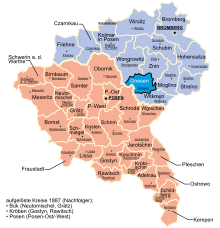
On October 1, 1887, the new Witkowo district was formed from the southeast half of the Gnesen district (588 km²) . The Witkowo police district , a large part of the Schwarzenau police district and the eastern part of the Gnesen II police district moved to this district .
On December 27, 1918, the Greater Poland uprising of the Polish majority against German rule began in the province of Posen , and on the same day the district town of Gniezno was under Polish control. On February 16, 1919, an armistice ended the Polish-German fighting, and on June 28, 1919, the German government officially ceded the Gnesen district to the newly founded Poland with the signing of the Treaty of Versailles . The Polish powiat Gniezno became from the Gnesen district . In 1925 the town of Gniezno was spun off from the powiat as a separate urban district . In 1927 the powiat Witkowo was dissolved again, the majority of 542 km² came back to the powiat Gniezno, a small part of 46 km² with the municipality of Marzenin came to the southern neighboring powiat Września .
Population development
| year | Residents | source |
|---|---|---|
| 1818 | 26,790 | |
| 1846 | 55,658 | |
| 1871 | 60,475 | |
| 1890 | 42,482 | |
| 1900 | 48,332 | |
| 1910 | 56,250 |
In 1905, 67% of the population were Polish and 33% German. Most of the German residents left the area after 1918.
politics
District administrators
- 1793–1806 Ignatius von Koszutski
- 1815-1816 by Zakrzewski
- 1816-1818 by Lekszycki
- 1818–1831 by Nowacki
- 1815–1845 from Grevenitz
- 1840–1845 Ernst Viebig (1810–1881) ( interim )
- 1847–1849 Albert Ferdinand Schliess ( acting )
- 1849–1862 Stahlberg
- 1862–1895 Otto Nollau
- 1895 Roetgen ( representative )
- 1895–1904 Robert Coeler († 1904)
- 1904–1919 Ludwig Dionysius (1868–1922)
elections
The circle Gniezno was, together with the county Wongrowitz the Reichstag constituency Bromberg 5 . The constituency was won by candidates from the Polish parliamentary group in all Reichstag elections :
- 1871 Konstantin von Dziembowski
- 1874 Joseph von Choslowsky
- 1877 Eustachius von Rogalinski
- 1878 Władysław Niegolewski
- 1881 Witold von Skarzynski
- 1884 Julian von Chelmicki
- 1887 Julian von Chelmicki
- 1890 novel by Komierowski
- 1893 novel by Komierowski
- 1898 novel by Komierowski
- 1903 Leon von Grabski
- 1907 Leon von Grabski
- 1912 Leon von Grabski
surface
The Gnesen district had an area of 1153 km² since 1818; after the Witkowo district was detached in 1887, it was 565 km².
cities and communes
Before the First World War, the Gnesen district comprised the following cities and rural communities:
|
|
|
|
Numerous manor districts also belonged to the district . The rural parishes and manor districts were combined to form police districts. In the period after 1871 a number of place names were Germanized:
- Biskupice → Bischofssee (1905)
- Bojanice → Bojanitze (1904)
- Braziszewo → Brazischewo (1904)
- Chwalkowo → Weissenburg (1904)
- Darmoszewo → Amberg (1904)
- Dembnica → Dembnitza (1906)
- Dziekanowice → Dziekanowitze (1903/08)
- Kaminiec → Kaminietz (1906)
- Kiszkowo → Welnau (1875)
- Komorowo → German Valley (1904)
- Royal Gulczewo → Kleedorf (1907)
- Krzysczewo → Kreuztal (1904)
- Lubowo → Libau (1875)
- Lubowo Hauland → Place of Peace (1904)
- Mnichowo → Mönchsee (1904)
- Polskawies → Paulsdorf (1901)
- Świniary → Bismarcksfelde
- Ułanowo → Ulenhof (1906) → Ulenhorst (1913)
- Waliszewo → Walsee (1904)
- Woznik → Wagenau (1907)
See also
- Gnesen district, a district established in occupied Poland during the Second World War
literature
- Gustav Neumann : Geography of the Prussian State . 2nd edition, Volume 2, Berlin 1874, pp. 162-163, item 8.
- Royal Statistical Bureau: The municipalities and manor districts of the Prussian state and their population. Edited and compiled from the original materials of the general census of December 1, 1871. Part IV: The Province of Posen , Berlin 1874, pp. 212-227 ( E-Copy, pp. 219-234 ).
- ACA Friedrich: Historical-geographical representation of old and new Poland . Berlin 1839, pp. 585-586.
- Leopold von Zedlitz-Neukirch : The state forces of the Prussian monarchy under Friedrich Wilhelm III . Volume 2, part 1, Berlin 1828, pp. 114-115, number III.
- M. Rademacher: German administrative history from the unification of the empire in 1871 to the reunification in 1990. (online material for the dissertation, Osnabrück 2006)
- Martin Sprungala: The history of the Poznan districts and independent cities. Bad Bevensen 2007.
- Martin Sprungala: Historical Directory of the Province of Poznan and the Poznań Voivodeship (Poznan). Bad Bevensen 2007.
Web links
- Gnesen district administrative history and the district administrators on the website territorial.de (Rolf Jehke), as of August 13, 2013.
Individual evidence
- ↑ Georg Hassel: Statistical outline of all European states . The statistical view and special statistics of Central Europe. Vieweg, Braunschweig 1805, p. 33 ( digitized version ).
- ^ Jerzy Benjamin Flatt: Topography of the Duchy of Warsaw . (German edition). Adam Friedrich Böhme, Leipzig 1810 ( digitized version ).
- ↑ Official Gazette of the Royal Prussian Government in Bromberg 1816, No. 21, page 244, digitized version
- ↑ a b Walther Hubatsch (Ed.): Outline of German administrative history 1815–1945. Johann Gottfried Herder Institute, Marburg / Lahn; Volume 2, Part 1: Province of Poznan. edited by Dieter Stüttgen, 1975, ISBN 3-87969-109-6
- ↑ Official Gazette of the Royal Prussian Government in Bromberg 1817, No. 51, page 839, digitized version
- ^ Christian Gottfried Daniel Stein: Handbook of Geography and Statistics of the Prussian State . Vossische Buchhandlung, Berlin 1819, p. 322 ( digitized version [accessed September 9, 2017]).
- ↑ Royal Statistical Bureau (ed.): Mittheilungen des Statistisches Bureau's in Berlin, Volume 2 . Population of the districts. S. 311 ( digitized version ).
- ^ The municipalities and manors of the Poznan Province and their population in 1871
- ^ A b c Michael Rademacher: German administrative history from the unification of the empire in 1871 to the reunification in 1990. Gnesen district. (Online material for the dissertation, Osnabrück 2006).
- ^ Rolf Straubel : Biographical manual of the Prussian administrative and judicial officials 1740–1806 / 15 . In: Historical Commission to Berlin (Ed.): Individual publications . 85. KG Saur Verlag, Munich 2009, ISBN 978-3-598-23229-9 .
- ↑ a b municipal register 1910 with population figures

Administrative districts: Bromberg | Poses
Districts: Poznan | Bromberg | Schneidemühl
Districts: Adelnau | Pear tree | Bomb | Bromberg | Czarnikau | Filehne | Fraustadt | Gostyn | Gniezno | Grätz | Hohensalza (formerly Inowrazlaw ) | Jarotschin | Kempen i. Poses | Kolmar i. Posen (formerly Chodziesen ) | Koshmin | Cost | Krotoschin | Lissa | Meseritz | Mogilno | Neuto Mischel | Obornik | Ostrowo | Pleschen | Poznan East | Poznan West | Rawitsch | Samter | Schildberg | Schmiegel | Schrimm | Schroda | Schubin | Schwerin an der Warthe | Strelno | We seat | Witkowo | Wongrowitz (formerly Wongrowiec ) | Wreschen (formerly Peysern ) | Tin