
Péry
| Péry | ||
|---|---|---|
 |
||
| State : |
|
|
| Canton : |
|
|
| Administrative district : | Bernese Jura | |
| Residential municipality : | Péry-La Heutte | |
| Postal code : | 2603 | |
| former BFS no. : | 0439 | |
| Coordinates : | 585 706 / 227042 | |
| Height : | 635 m above sea level M. | |
| Area : | 15.57 km² | |
| Residents: | 1359 (December 31, 2013) | |
| Population density : | 87 inhabitants per km² | |
| Website: | www.pery-laheutte.ch | |
 Rondchâtel |
||
| map | ||
|
||

Péry is a place in the municipality of Péry-La Heutte , which is in the Bernese Jura administrative district in the canton of Bern in Switzerland . The former German name Büderich is no longer used today.
Until December 31, 2014, Péry was an independent political municipality . On January 1, 2015, Péry merged with the municipality of La Heutte to form the new municipality of Péry-La Heutte .
geography

Péry is 635 m above sea level. M. , seven kilometers north of Biel (as the crow flies). The clustered village extends at the southern foot of the Jura range of the Montoz , in the valley of the Schüss ( French Suze ), above the gorge of Rondchâtel. Shortly before the entrance to the Klus, the Seitenbach Terbez flows into the Schüss from the east .
The area of the 15.6 square kilometers large former municipal area includes the Terbez valley, which lies between two Jura chains, and a small section of the lower Schüsstal. To the north, the former municipality extends to the crest of the anticlines of the Montoz, on which at 1312 m above sea level. M. the highest point of Péry is reached. South of the village, the valley of the Schüss through the anticline of the Chasseral chain belongs to Péry. It forms a typical Jurassic ridge with up to 500 m high valley flanks, which are criss-crossed by striking rock faces. In 1997, 10% of the municipal area was in settlements, 67% in forests and woodlands, 22% in agriculture and a little less than 1% was unproductive land.
Péry includes the Reuchenette settlements ( 596 m above sea level ) at the upper entrance to the gorge of Rondchâtel and Rondchâtel ( 580 m above sea level ) in the Schüss gorge of the same name, as well as several individual farms. Neighboring communities of Péry were Orvin , Sauge , Romont , Sorvilier , Bévilard , Malleray , Reconvilier , Tavannes and La Heutte.
history
The first written mention of Péry was in 884, in 1228 the name Perril appeared . The former German place name Büderich or Böderich goes back to Villa Bederica ( settlement of Bederich ). Until 1797 the village belonged to the Erguel lordship , which was subordinate to the Duchy of Basel , although the city of Biel also exerted greater influence at times. From 1797 to 1815 Péry belonged to France and was initially part of the Mont-Terrible department , which was connected to the Haut-Rhin department in 1800 . As a result of the decision of the Congress of Vienna , the place came to the canton of Bern in the Courtelary district in 1815 .
Until December 31, 2014, Péry was an independent municipality .
population
| Population development | |
|---|---|
| year | Residents |
| 1850 | 560 |
| 1900 | 983 |
| 1910 | 1'201 |
| 1930 | 1,076 |
| 1950 | 1,124 |
| 1960 | 1,304 |
| 1970 | 1,486 |
| 1980 | 1,449 |
| 1990 | 1'405 |
| 2000 | 1,335 |
With 1,359 inhabitants (as of December 31, 2013), Péry was one of the larger municipalities of the Bernese Jura . 79.6% of the residents are French-speaking, 15.4% German-speaking and 2.3% Italian-speaking (as of 2000). The population of Péry increased sharply, especially in the second half of the 19th century until 1910. After peaking around 1970, a slightly downward trend has been observed since then.
politics
The voting shares of the parties on the occasion of the National Council elections in 2011 were: SVP 35.2%, SP 25.5%, GPS 10.3%, FDP 9.3%, BDP 6.4%, glp 2.4%, EPP 2.3 %, CVP 1.9%, EDU 1.8%, Les Rauraques 1.6%, Pirates 1.0%, AL 1.0%.
economy
In the middle of the 18th century, Péry developed from an agricultural community into an industrial community. As early as 1654, at the behest of the Prince-Bishop of Basel Johann Franz von Schönau , a foundry was set up in Reuchenette , which was later converted into an iron wire drawing and sawmill . Today there is a large cement factory in the cave . There used to be a paper mill near Rondchâtel. In the Rondchâtel Klus there are large quarries where Jurassic limestone is extracted.
traffic
The former community is well developed in terms of traffic. It is located on the main road from Biel to La Chaux-de-Fonds and on the four-lane A16 , which has been accessible from Biel to Tavannes since 1997 . On April 30, 1874, the railway line from Biel to Convers was opened with a train station in Péry.
Attractions
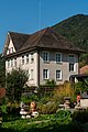
The reformed village church was built in 1706 using parts of the previous Gothic building; In 1910 extensive renovation and redesign took place. In the old town center there are still numerous classicist houses from the period 1834–43; the rectory dates from 1833. On a wooded hill above the confluence of the Terbez in the Schüss stand the Catholic chapel Ste-Marie from 1904 and ruins of the castle Châtillon , which was the seat of the Péry servants from the 13th century. In the gorge of Rondchâtel , on a hill surrounded by the Schüss, are the remains of the Rondchâtel castle, a fortification with a rounded wall system.
Above Frinvillier, at the entrance to the Rondchâtel gorge, traces of a Roman road are visible at Martinsklafter .

CFF / SBB train station
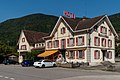
Hotel de la Truite
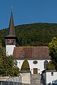
reformed Church

Rectory

Local government
The older schoolhouse

School complex

Community center
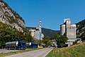
Vigier SA cement plant


Web links
- Official website of the municipality of Péry
- Christine Gagnebin-Diacon: Péry. In: Historical Lexicon of Switzerland .
Individual evidence
- ↑ http://www.wahlarchiv.sites.be.ch/wahlen2011/target/NAWAInternetAction.do@method=read&sprache=d&typ=21&gem=439.html accessed on March 15, 2012
Belprahon | Champoz | Corcelles | Corgémont | Cormoret | Cortébert | Court | Courtelary | Crémines | Eschert | Grandval | La Ferrière | La Neuveville | Loveresse | Mont-Tramelan | Moutier | Nods | Orvin | Perrefitte | Péry-La Heutte | Petit-Val | Plateau de Diesse | Rebévelier | Reconvilier | Renan | Roches | Romont | Saicourt | Saint-Imier | Suction | Saules | Scolding (La Scheulte) | Seehof (Elay) | Sonceboz-Sombeval | Sonvilier | Sorvilier | Tavannes | Tramelan | Valbirse | Villeret
Former municipalities: Bévilard | Châtelat | This | La Heutte | Lamboing | Malleray | Monible | Péry | Plagne | Pontenet | Prêles | Sornetan | Souboz | Tramelan lingerie | Tramelan Dessus | Vauffelin
Canton of Bern | Administrative districts of the canton of Bern | Municipalities of the Canton of Bern