Peynier
| Peynier | ||
|---|---|---|

|
|
|
| region | Provence-Alpes-Cote d'Azur | |
| Department | Bouches-du-Rhône | |
| Arrondissement | Aix-en-Provence | |
| Canton | Pedal | |
| Community association | Métropole d'Aix-Marseille-Provence | |
| Coordinates | 43 ° 27 ' N , 5 ° 39' E | |
| height | 211-500 m | |
| surface | 24.76 km 2 | |
| Residents | 3,480 (January 1, 2017) | |
| Population density | 141 inhabitants / km 2 | |
| Post Code | 13790 | |
| INSEE code | 13072 | |
| Website | www.peynier.fr | |
 Peynier |
||
Peynier is a French municipality with 3480 inhabitants (at January 1, 2017) in the department of Bouches-du-Rhône in the region of Provence-Alpes-Cote d'Azur .
geography
The municipality is located 22 kilometers southeast of Aix-en-Provence . Neighboring municipalities are Trets , Rousset and Fuveau .
history
There was already a settlement here in ancient times, as evidence shows. The name is derived from Puium Neroni (1008) and Podium nigrum . In the 13th century the place, or the fortress, was called castrum de Puei-nier . It means something like black mountain . In the late Middle Ages, the Counts and Abbots of Marseilles ruled the village. The village was later ravaged by the Wars of Religion and was hit by a heavy frost in the winter of 1709.
Demographics
Population development
| year | 1962 | 1968 | 1975 | 1982 | 1990 | 1999 | 2008 | 2016 |
| Residents | 690 | 819 | 1,160 | 1,741 | 2,475 | 2,779 | 3,007 | 3,405 |
age structure
24 percent of the population are 19 years old or younger. Six percent of the population are 75 years of age or older.
Attractions
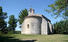
- Chapel of Saint Pierre from the 11th century, Monument historique
- Parish Church of Saint Julien
- Renaissance castle from the 17th century

