Rožkovany
| Rožkovany | ||
|---|---|---|
| coat of arms | map | |

|
|
|
| Basic data | ||
| State : | Slovakia | |
| Kraj : | Prešovský kraj | |
| Okres : | Sabinov | |
| Region : | Šariš | |
| Area : | 14.052 km² | |
| Residents : | 1,331 (Dec 31, 2019) | |
| Population density : | 95 inhabitants per km² | |
| Height : | 369 m nm | |
| Postal code : | 082 71 ( Lipany Post Office ) | |
| Telephone code : | 0 51 | |
| Geographic location : | 49 ° 8 ′ N , 20 ° 59 ′ E | |
| License plate : | SB | |
| Kód obce : | 525120 | |
| structure | ||
| Community type : | local community | |
| Administration (as of November 2018) | ||
| Mayor : | Beáta Kollárová | |
| Address: | Obecný úrad Rožkovany č. 106 082 71 Lipany |
|
| Website: | www.rozkovany.sk | |
| Statistics information on statistics.sk | ||
Rožkovany (until 1948 Slovak "Roškoviany" - to 1927 "Rožkoviany"; Hungarian Roskovány ) is a municipality in the east of Slovakia with a population of 1,331 (December 31, 2019). It belongs to the Okres Sabinov , a district of the Prešovský kraj , as well as to the traditional Šariš landscape .
geography
The village is located in the middle of the Torysa Valley on the northern slope of the Bachureň Mountains . The Repisko brook flows through Rožkovany . The municipal area is hilly to mountainous and largely deforested, there is a sulfur spring in the area. The center of the village lies at an altitude of 369 m nm and is three and a half kilometers from Lipany and nine and a half kilometers from Sabinov .
Neighboring municipalities are Milpoš in the north, Červenica pri Sabinove in the northeast, Jakubova Voľa in the east, Uzovské Pekľany and Renčišov in the south, Dubovica in the west and Lipany in the northwest.
history
A predecessor town already existed in the 13th century and was first mentioned in writing in 1278 as Hozumezeu ; at that time the village was already devastated. The present place was mentioned for the first time in a document of the diocese of Eger as Roschowicz . In 1427 the village had 41 porta , which at that time corresponded to a large village. In the Middle Ages Rožkovany was owned by different families, from the 16th century the Roskoványi family owned the majority of the estates, in the 19th century families such as Bánó , Czabalay , Péchy and Szentiványi also had shares. In 1828 there were 103 houses and 759 inhabitants, whose main sources of income were agriculture, linen weaving and fruit growing. After the abolition of serfdom there were several waves of emigration, so that the population in 1910 was 591.
Until 1918, the place in Sharosh County belonged to the Kingdom of Hungary and then came to Czechoslovakia or now Slovakia.
population
According to the 2011 census, 1311 inhabitants lived in Rožkovany, of which 1243 were Slovaks , five Roma , two Russians and one Moravian , one Pole and one Czech . 58 residents did not give any information about their ethnicity .
1198 residents supported the Roman Catholic Church, 21 residents the Greek Catholic Church, three residents the Orthodox Church and one resident of the Evangelical Church AB; six residents professed a different denomination. Three residents were non-denominational and the denomination of 20 residents was not determined.
Buildings and monuments
- Roman Catholic church in classicist style from 1858
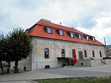
- Country palace in mixed baroque and classicist style from 1770
traffic
Rožkovany is accessed by the short 3rd order street 3188, which ends north of the built-up area at 1st order street 68 ( Ľubotín - Prešov ). The municipality also has a connection to the Kysak – Muszyna railway via the Rožkovany stop. There are bus stops not far from here.
Individual evidence
- ↑ Results of the 2011 census (Slovak)
- ↑ http://www.cdb.sk/files/img/precislovanieck/podkladymdvrrsr/presovsky_kraj_100-000.jpg
Web links
- Entry on e-obce.sk (Slovak)


