
Saint-Épain
| Saint-Épain | ||
|---|---|---|
.svg)
|
|
|
| region | Center-Val de Loire | |
| Department | Indre-et-Loire | |
| Arrondissement | Quinone | |
| Canton | Sainte-Maure-de-Touraine | |
| Community association | Touraine Val de Vienne | |
| Coordinates | 47 ° 9 ' N , 0 ° 32' E | |
| height | 47-122 m | |
| surface | 62.65 km 2 | |
| Residents | 1,572 (January 1, 2017) | |
| Population density | 25 inhabitants / km 2 | |
| Post Code | 37800 | |
| INSEE code | 37216 | |

Saint-Épain is a French commune with 1,572 inhabitants (at January 1, 2017) in Indre-et-Loire in the region of Center-Val de Loire ; it belongs to the arrondissement of Chinon and the canton of Sainte-Maure-de-Touraine .
geography
The place is on the river Manse . Neighboring municipalities of Saint-Épain are Neuil in the north, Villeperdue in the northeast, Sainte-Catherine-de-Fierbois in the east, Sainte-Maure-de-Touraine in the southeast, Noyant-de-Touraine in the south, Crouzilles in the southwest and Crissay-sur- Manse in the west.
history
First mentioned in 774 as "Brigogalus". Mention of the church "Sanctus Spanus" in the year 857. Adoption of the patronage as a place name probably in the 11th century. In 1790/94 the neighboring Montgauger was incorporated.
Population development
| year | 1962 | 1968 | 1975 | 1982 | 1990 | 1999 | 2007 | 2012 |
| Residents | 1,670 | 1,525 | 1,338 | 1,409 | 1,335 | 1,418 | 1,529 | 1,552 |
Attractions
- Saint-Épain church (12th / 16th century)
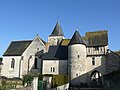
- Ruins of the Château Montgoger, the center of an 11th century feudal rule
- Notre-Dame-de-Lorette rock chapel (15th century)
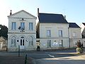
The Mairie
The church

Montgoger

Notre-Dame de Lorette


literature
- Le Patrimoine des Communes d'Indre-et-Loire. Flohic Editions, Volume 2, Paris 2001, ISBN 2-84234-115-5 , pp. 1244-1249.