
Restigné
| Restigné | ||
|---|---|---|
|
||
| region | Center-Val de Loire | |
| Department | Indre-et-Loire | |
| Arrondissement | Quinone | |
| Canton | Langeais | |
| Community association | Touraine Ouest Val de Loire | |
| Coordinates | 47 ° 15 ' N , 0 ° 13' E | |
| height | 30-114 m | |
| surface | 21.31 km 2 | |
| Residents | 1,226 (January 1, 2017) | |
| Population density | 58 inhabitants / km 2 | |
| Post Code | 37140 | |
| INSEE code | 37193 | |
| Website | www.restigne.fr | |
 Town hall ( Mairie ) of Restigné |
||

Restigné is a French commune with 1,226 inhabitants (as of January 1 2017) in Indre-et-Loire in the region of Center-Val de Loire ; it belongs to the arrondissement of Chinon and the canton of Langeais (until 2015: canton of Bourgueil ). The inhabitants are called Restignons .
geography
Restigné is about 36 kilometers west-southwest of Tours in the Loire Valley . Restigné is surrounded by the neighboring communities of Benais in the north, Continvoir in the north and northeast, Saint-Michel-sur-Loire in the east and northeast, Ingrandes-de-Touraine in the east, La Chapelle-sur-Loire in the south and Bourgueil in the west.
Population development
| year | 1962 | 1968 | 1975 | 1982 | 1990 | 1999 | 2006 | 2017 |
| Residents | 1386 | 1302 | 1198 | 1210 | 1187 | 1225 | 1162 | 1226 |
| Sources: Cassini and INSEE | ||||||||
Attractions
- Saint-Martin church from the 12th century, monument historique
- Louy Castle
- La Plâterie Castle (Restigné mansion) with park, historic monument
- La Philberdière Castle
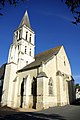
Saint Martin Church

Louy Castle

La Plâterie Castle
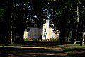
La Philberdière Castle


partnership
There is a partnership with the district of Jandrain-Jandrenouille in the municipality of Orp-Jauche in Wallonia .
literature
- Le Patrimoine des Communes d'Indre-et-Loire. Flohic Editions, Volume 1, Paris 2001, ISBN 2-84234-115-5 , pp. 280-286.