
Channay-sur-Lathan
| Channay-sur-Lathan | ||
|---|---|---|
|
||
| region | Center-Val de Loire | |
| Department | Indre-et-Loire | |
| Arrondissement | Quinone | |
| Canton | Langeais | |
| Community association | Touraine Ouest Val de Loire | |
| Coordinates | 47 ° 29 ′ N , 0 ° 16 ′ E | |
| height | 71-91 m | |
| surface | 28.71 km 2 | |
| Residents | 841 (January 1, 2017) | |
| Population density | 29 inhabitants / km 2 | |
| Post Code | 37330 | |
| INSEE code | 37055 | |

Channay-sur-Lathan is a French municipality with 841 inhabitants (at January 1, 2017) in the department of Indre-et-Loire in the region of Center-Val de Loire . It belongs to the Arrondissement of Chinon and is part of the canton of Langeais (until 2015: canton of Château-la-Vallière ). The inhabitants are called Chanéens .
geography
Channay-sur-Lathan is about 34 kilometers west-northwest of Tours and about 60 kilometers east of Angers . The Lathan River runs along the southeastern municipal boundary . Channay-sur-Lathan is surrounded by the neighboring communities of Saint-Laurent-de-Lin in the north, Courcelles-de-Touraine in the east, Savigné-sur-Lathan in the southeast, Hommes in the south and southeast, Rillé in the south and Noyant-Villages in the West.
Population development
| year | 1962 | 1968 | 1975 | 1982 | 1990 | 1999 | 2006 | 2012 |
| Residents | 773 | 792 | 666 | 569 | 578 | 595 | 755 | 832 |
| Source: Cassini and INSEE | ||||||||
Attractions
- Saint-Quentin Church, a historic monument since 1948
- Le Mesnil mansion, 17th century house, historic monument since 1948
- Les Hayes mansion, 15th century tower, 17th century chapel, historic monument since 1948
- La Barrée mansion from the 16th century

Saint-Quentin Church
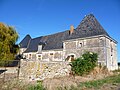
Le Mesnil mansion


literature
- Le Patrimoine des Communes d'Indre-et-Loire. Flohic Editions, Volume 1, Paris 2001, ISBN 2-84234-115-5 , pp. 322-325.