
Cerelles
| Cerelles | ||
|---|---|---|
|
||
| region | Center-Val de Loire | |
| Department | Indre-et-Loire | |
| Arrondissement | Quinone | |
| Canton | Château-Renault | |
| Community association | Gâtine et Choisilles-Pays de Racan | |
| Coordinates | 47 ° 30 ' N , 0 ° 41' E | |
| height | 62-122 m | |
| surface | 12.3 km 2 | |
| Residents | 1,198 (January 1, 2017) | |
| Population density | 97 inhabitants / km 2 | |
| Post Code | 37390 | |
| INSEE code | 37047 | |
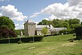
 Town hall (Mairie) of Cerelles |
||

Cerelles is a French commune with 1,198 inhabitants (as of January 1 2017) in Indre-et-Loire in the region of Center-Val de Loire ; it belongs to the arrondissement of Chinon and the canton of Château-Renault (until 2015: canton of Neuillé-Pont-Pierre ). The inhabitants are called Cerellois .
geography
Cerelles is about twelve kilometers north of Tours . Cerelles is surrounded by the neighboring communities of Rouziers-de-Touraine in the north and north-west, Nouzilly in the east and north-east, Chanceaux-sur-Choisille in the south and Saint-Antoine-du-Rocher in the west.
Population development
| year | 1962 | 1968 | 1975 | 1982 | 1990 | 1999 | 2006 | 2013 |
| Residents | 392 | 401 | 437 | 575 | 793 | 982 | 1,211 | 1,216 |
| Source: Cassini and INSEE | ||||||||
Attractions
,_l%27%C3%A9glise_01.JPG)
- Saint-Pierre church
- Town hall, formerly La Grand'Maison from 1641
- Baudry Castle
- La Bédouère Castle
- La Chesnaye Castle
- Châtenay manor
La Bédouère Castle

La Chesnaye Castle


literature
- Le Patrimoine des Communes d'Indre-et-Loire. Flohic Editions, Volume 2, Paris 2001, ISBN 2-84234-115-5 , pp. 1016-1018.
Web links
Commons : Cerelles - collection of images, videos and audio files