
Saint-Hilaire-la-Gravelle
| Saint-Hilaire-la-Gravelle | ||
|---|---|---|
.svg)
|
|
|
| region | Center-Val de Loire | |
| Department | Loir-et-Cher | |
| Arrondissement | Vendôme | |
| Canton | Le Perche | |
| Community association | Le Perche et Haut Vendômois | |
| Coordinates | 47 ° 56 ' N , 1 ° 12' E | |
| height | 87-172 m | |
| surface | 17.57 km 2 | |
| Residents | 717 (January 1, 2017) | |
| Population density | 41 inhabitants / km 2 | |
| Post Code | 41160 | |
| INSEE code | 41214 | |

Saint-Hilaire-la-Gravelle is a French municipality with 717 inhabitants (as of January 1 2017) in the department of Loir-et-Cher in the region Center-Val de Loire . Administratively, it is assigned to the canton of Le Perche (until 2015: canton of Morée ) and the arrondissement of Vendôme . The inhabitants are called Gravellois or Saint-Hilairiens .
geography
Saint-Hilaire-la-Gravelle is located about 38 kilometers north-north-west of Blois in the Le Perche region on the Loir , which forms the eastern municipal boundary. Saint-Hilaire-la-Gravelle is surrounded by the neighboring municipalities of Fontaine-Raoul in the north and north-west, Saint-Jean-Froidmentel in the north and north-east, Brévainville in the north-east, Morée in the east, Fréteval in the south, Busloup in the west and south-west and La Ville -aux-Clercs to the west.
The National Route 10 runs through the municipality .
Population development
| year | 1936 | 1946 | 1954 | 1962 | 1968 | 1975 | 1982 | 1990 | 1999 | 2006 | 2013 |
|---|---|---|---|---|---|---|---|---|---|---|---|
| Residents | 511 | 450 | 540 | 537 | 558 | 556 | 663 | 648 | 687 | 690 | 688 |
| Source: Cassini and INSEE | |||||||||||
Attractions
- Dolmen de la Couture
- 12th century Saint-Hilaire church

Dolmen de la Couture
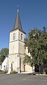
Saint-Hilaire church

