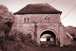
Azé (Loir-et-Cher)
| Azé | ||
|---|---|---|

|
|
|
| region | Center-Val de Loire | |
| Department | Loir-et-Cher | |
| Arrondissement | Vendôme | |
| Canton | Vendôme | |
| Community association | Territoires Vendômois | |
| Coordinates | 47 ° 51 ′ N , 1 ° 0 ′ E | |
| height | 80-154 m | |
| surface | 31.93 km 2 | |
| Residents | 1,033 (January 1, 2017) | |
| Population density | 32 inhabitants / km 2 | |
| Post Code | 41100 | |
| INSEE code | 41010 | |
Azé is a French commune with 1,033 inhabitants (as of January 1 2017) in the department of Loir-et-Cher in the region Center-Val de Loire ; it belongs to the Arrondissement of Vendôme and the Canton of Vendôme (until 2015: Canton Vendôme-1 ). The inhabitants are called Azéens .
geography
Azé is a banlieue in the north of Vendôme and is located about 38 kilometers north-northwest of Blois . Azé is surrounded by the neighboring municipalities of Danzé in the north, Rahart in the east, Saint-Ouen in the southeast, Vendôme in the south and southeast, Villiers-sur-Loir in the south and southwest, Mazangé in the west and Épuisay in the northwest. Azé is located on the Boulon River , which seeps underground south of Danzé and reappears as a karst spring after about five kilometers in the local area of Azé .
Population development
| year | 1962 | 1968 | 1975 | 1982 | 1990 | 1999 | 2006 | 2013 |
| Residents | 683 | 714 | 675 | 662 | 820 | 985 | 1,089 | 1,092 |
| Source: Cassini and INSEE | ||||||||
Attractions
- Saint-Pierre Church, Monument historique
- Courtozé Priory, Monument historique
- Castles of Beaulieu, Courtozé, La Rouillière, Minière and Morillon

