
Baillou (Loir-et-Cher)
| Baillou | ||
|---|---|---|

|
|
|
| region | = Center-Val de Loire | |
| Department | Loir-et-Cher | |
| Arrondissement | Vendôme | |
| Canton | Le Perche | |
| Community association | Collines du Perche | |
| Coordinates | 47 ° 58 ' N , 0 ° 51' E | |
| height | 88-166 m | |
| surface | 19.85 km 2 | |
| Residents | 226 (January 1, 2017) | |
| Population density | 11 inhabitants / km 2 | |
| Post Code | 41170 | |
| INSEE code | 41012 | |

Baillou is a municipality in France Loir-et-Cher in the Administrative Region Center-Val de Loire . It belongs to the canton of Le Perche and the arrondissement of Vendôme . It borders in the north-west on Valennes , in the north on Couëtron-au-Perche with Souday , in the north-east on Choue , in the east on Mondoubleau , in the south-east on Cormenon , in the south on Sargé-sur-Braye and in the south-west on Rahay .
Population development
| year | 1962 | 1968 | 1975 | 1982 | 1990 | 1999 | 2008 | 2015 |
|---|---|---|---|---|---|---|---|---|
| Residents | 410 | 354 | 276 | 250 | 230 | 229 | 248 | 252 |
Attractions
- Castle of Baillou
- Saint-Jean-Baptiste church from the 15th / 16th centuries Century, when in 1948 Monument historique reported

Castle of Baillou
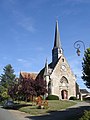
The Saint-Jean-Baptiste church
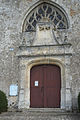
Renaissance style church portal


Web links
Commons : Baillou - collection of images, videos and audio files