Saint-Sébastien (Creuse)
| Saint-Sébastien | ||
|---|---|---|
|
|
||
| region | Nouvelle-Aquitaine | |
| Department | Creuse | |
| Arrondissement | Guéret | |
| Canton | Dun-le-Palestel | |
| Community association | Monts et Vallées Ouest Creuse | |
| Coordinates | 46 ° 24 ' N , 1 ° 32' E | |
| height | 244-361 m | |
| surface | 24.98 km 2 | |
| Residents | 647 (January 1, 2017) | |
| Population density | 26 inhabitants / km 2 | |
| Post Code | 23160 | |
| INSEE code | 23239 | |
Saint-Sébastien is a commune in the Massif Central in France . It belongs to the Nouvelle-Aquitaine region , the Creuse department , the Guéret arrondissement and the Dun-le-Palestel canton .
Geography and infrastructure
Saint-Sébastien is bordered by Mouhet to the west, Parnac to the northwest , Éguzon-Chantôme to the north, Crozant to the east, La Chapelle-Baloue to the southeast, Bazelat to the south and Azerables to the southwest .
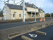
The village has a train station on the Les Aubrais-Orléans-Montauban-Ville-Bourbon railway in the Vaussujean district. This is where trains of the TER Nouvelle-Aquitaine Orléans - Limoges stop .
The Abloux flows through the municipal marker .
Population development
| year | 1962 | 1968 | 1975 | 1982 | 1990 | 1999 | 2008 | 2013 |
|---|---|---|---|---|---|---|---|---|
| Residents | 1,134 | 1,064 | 973 | 854 | 736 | 705 | 692 | 677 |
Web links
Commons : Saint-Sébastien - Collection of images, videos and audio files

