
Sinn (Hessen)
| coat of arms | Germany map | |
|---|---|---|
.png)
|
Coordinates: 50 ° 39 ′ N , 8 ° 20 ′ E |
|
| Basic data | ||
| State : | Hesse | |
| Administrative region : | to water | |
| County : | Lahn-Dill district | |
| Height : | 241 m above sea level NHN | |
| Area : | 18.72 km 2 | |
| Residents: | 6367 (Dec. 31, 2019) | |
| Population density : | 340 inhabitants per km 2 | |
| Postal code : | 35764 | |
| Primaries : | 02772, 06449 (Edingen) | |
| License plate : | LDK, DIL | |
| Community key : | 06 5 32 020 | |
| Address of the municipal administration: |
Jordanstrasse 2 35764 Sinn |
|
| Website : | ||
| Mayor : | Hans-Werner Bender (independent) | |
| Location of the community of Sinn in the Lahn-Dill district | ||
  |
||

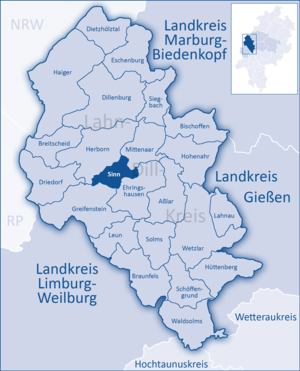
Sinn is a municipality in the Lahn-Dill district in central Hesse .
geography
Geographical location
Sinn is located 185 to 356 meters above sea level at the foot of the Westerwald , three kilometers south of Herborn in the Dill Valley .
.jpg)
Neighboring communities
Sinn borders in the northeast on the municipality of Mittenaar , in the east on the municipality Ehringshausen , in the south on the municipality Greifenstein and in the northwest on the city of Herborn (all in the Lahn-Dill district).
structure
The districts belong to the greater community of Sinn (6,636 inhabitants)
history
The fertile slopes and side valleys of the Dill Valley were populated very early on. During excavations at the beginning of the 1950s, fragments, remains of utility tools, house floor plans, fireplaces and a gemstone from Roman times were found. Archaeological finds in the Edingen district run through all epochs and suggest a permanent settlement since the 4th century BC. Documents prove the existence of all three sub-locations since the 13th century.
Edingen and Fleisbach were shaped by agriculture and kept this structure until the middle of the 20th century. Meaning, however, was captured by the industrial revolution in the mid-19th century. Favored by the mining industry in the Sieg-Dill area, a steelworks settled, followed by foundries and metalworking companies.
The old cemetery with its gravestones reflected the origins of the “old and new Sinner” employed in the Sinner iron and steel industry. There are now only a few graves left in this cemetery, such as those of the hut directors of the Haas & Sohn company, who ran the Neuhoffnungshütte, who died in Sinn . Otto Haas measured his future grave in the presence of other senses while he was still alive by lying down in the recently dug pit. According to tradition, he was a joker at all; in winter he is said to have thrown coins between the skaters on the frozen first Stippbach pond, which led to a violent tussle. One of the missing or removed tombstones is the reddish, natural rock on the grave of the forester Schiebel. Also disappeared are two black and white painted wooden crosses, which came from the time of Hans-Erich Hess (also written with "sz") as parish priest (1930–1950, member of the confessing church, later senior church councilor of Hesse and Nassau) remembered the funeral of two "Russian girls" ( forced laborers ) during the Second World War.
The old cemetery in Sinn is an important testimony to the local history, although most of the historical gravestones have been removed. The old, small half-timbered church, which has been empty for a good four decades and is dedicated to those killed and missing in the World War, is a testimony to history; “Gutted” from the “inventory” from Calvinist- Nassau times, it was used until the late 1950s and was originally left in place. The clerk, the dean Blöcher and the deacon widow Weidenbach were the only participants in these evening services.
Hundreds of US 1 and 2 hundredweight bombs fell on the community of Sinn during World War II, but only two hit, causing only limited damage. The rest did not fall on the intended targets, such as the Gießen – Cologne railway line, or industrial and residential areas of Sinn, but fell on the hearth between Sinn and Edingen, where the bomb craters are still clearly visible today. Duds cannot be ruled out in this "bomb crater landscape under the forest".
Educated, socially committed personalities had also grown out of the non-church Sinner workers, such as the future mayor Reucker (machinist at Haas & Sohn), the communist Schwan, who protected many Sinner from attacks in the first days after the war, or the former Reinhold Simon, who knew the Sinner forest, the nature and the history of the Sinner pre-war, war and post-war years better than others.
As part of the regional reform in Hesse on January 1, 1977, the previously independent communities of Edingen and Fleisbach were incorporated into the community of Sinn by means of state law . Local districts with local advisory councils and local councilors were set up for all formerly independent communities .
Territorial history and administration
The following list gives an overview of the territories in which Sinn was located or the administrative units to which it was subject:
- before 1739: Holy Roman Empire , County / Principality of Nassau-Dillenburg , Herborn office
- from 1739: Holy Roman Empire, Principality of Nassau-Diez , Herborn Office
- 1806–1813: Grand Duchy of Berg , Department of Sieg , Canton of Herborn
- 1813–1815: Principality of Nassau-Orange , Herborn office
- from 1816: German Confederation , Duchy of Nassau , Herborn office
- from 1849: German Confederation, Duchy of Nassau, Herborn district office
- from 1854: German Confederation, Duchy of Nassau, Herborn Office
- from 1867: North German Confederation , Kingdom of Prussia , Province of Hessen-Nassau , Administrative Region of Wiesbaden , Dillkreis
- from 1871: German Empire , Kingdom of Prussia, Province of Hessen-Nassau, administrative district of Wiesbaden, Dillkreis
- from 1918: German Empire, Free State of Prussia , Province of Hessen-Nassau, Administrative Region of Wiesbaden, Dillkreis
- from 1932: German Empire, Free State of Prussia, Province of Hesse-Nassau, District of Wiesbaden, District of Dillenburg
- from 1933: German Reich, Free State of Prussia, Province of Hessen-Nassau, Administrative Region of Wiesbaden, Dillkreis
- from 1944: German Empire, Free State of Prussia, Nassau Province , Dill District
- from 1945: American occupation zone , Greater Hesse , Wiesbaden district, Dillkreis
- from 1949: Federal Republic of Germany , State of Hesse , Wiesbaden district, Dillkreis
- from 1968: Federal Republic of Germany, State of Hesse, administrative district Darmstadt , Dillkreis
- On January 1, 1977, Sinn was incorporated as a district of the newly formed community of Sinn. The seat of the municipal administration is meaning.
- from 1977: Federal Republic of Germany, State of Hesse, Darmstadt administrative district, Lahn-Dill district
- from 1981: Federal Republic of Germany, State of Hesse, Gießen administrative district , Lahn-Dill district
population
Population development
| Sinn: Population figures from 1834 to 2015 | ||||
|---|---|---|---|---|
| year | Residents | |||
| 1834 | 361 | |||
| 1840 | 391 | |||
| 1846 | 400 | |||
| 1852 | 392 | |||
| 1858 | 435 | |||
| 1864 | 481 | |||
| 1871 | 554 | |||
| 1875 | 527 | |||
| 1885 | 954 | |||
| 1895 | 817 | |||
| 1905 | 1,474 | |||
| 1910 | 1,627 | |||
| 1925 | 1,546 | |||
| 1939 | 1,759 | |||
| 1946 | 2,428 | |||
| 1950 | 2,885 | |||
| 1956 | 3,514 | |||
| 1961 | 3,921 | |||
| 1967 | 4.210 | |||
| 1970 | 4.141 | |||
| 1972 | 4.191 | |||
| 1976 | 6,282 | |||
| 1984 | 5,889 | |||
| 1992 | 6,294 | |||
| 2000 | 6,500 | |||
| 2004 | 6,630 | |||
| 2010 | 6,500 | |||
| 2015 | 6,400 | |||
| Data source: Historical municipality register for Hesse: The population of the municipalities from 1834 to 1967. Wiesbaden: Hessisches Statistisches Landesamt, 1968. Further sources:; 1972 :; 1976 :; 1984 :; 1992 :; 2000.2015 :; 2004 :; 2010: From 1976 including the towns incorporated into Hesse as part of the regional reform . | ||||
Religious affiliation
Source: Historical local dictionary
- 1885: 880 Protestant (= 92.24%), 74 Catholic (= 7.76%) inhabitants
- 1961: 2576 Protestant (= 65.70%), 1257 Catholic (= 32.06%) inhabitants
politics
Community representation
The local elections on March 6, 2016 produced the following results, compared to previous local elections:
| Parties and constituencies |
% 2016 |
Seats 2016 |
% 2011 |
Seats 2011 |
% 2006 |
Seats 2006 |
% 2001 |
Seats 2001 |
||
|---|---|---|---|---|---|---|---|---|---|---|
| CDU | Christian Democratic Union of Germany | 31.8 | 7th | 38.1 | 9 | 39.7 | 9 | 37.0 | 12 | |
| SPD | Social Democratic Party of Germany | 30.0 | 7th | 31.4 | 7th | 35.0 | 8th | 36.0 | 11 | |
| GREEN | Alliance 90 / The Greens | 12.6 | 3 | 15.5 | 3 | 7.4 | 2 | 7.0 | 2 | |
| FWG | Free community of voters sense | 25.7 | 6th | 11.5 | 3 | 9.5 | 2 | - | - | |
| FDP | Free Democratic Party | - | - | 3.5 | 1 | 8.3 | 2 | - | - | |
| FWG / UBLS | Free Community of Voters Sinn / Independent Citizens List Sinn | - | - | - | - | - | - | 13.4 | 4th | |
| FDBS | Free Democratic Citizens Association Sense | - | - | - | - | - | - | 6.7 | 2 | |
| total | 100.0 | 23 | 100.0 | 23 | 100.0 | 23 | 100.0 | 31 | ||
| Voter turnout in% | 43.4 | 37.8 | 36.9 | 45.0 | ||||||
mayor
In May 2012, Hans-Werner Bender was elected to succeed Hubert Koch (SPD).
Culture and sights
Buildings
With the Rudolfstraße / Hansastraße building ensemble , the community of Sinn has a historical site that has a unique selling point nationwide and is therefore protected as a whole and worthy of preservation. Around the stately complex Park and Villa Haas (architect Ludwig Hofmann) are lined up lavishly and individually designed villas of the senior officials and employees, from whom a residence obligation was initially expected. In direct relation to this, the former Neuhoffnungshütte opposite can be seen, which also housed a cruet and a consumption establishment. The upstream sleeping quarters and a palm house with park and plant nursery were demolished in the 1960s and 80s, as their historical significance was not sufficiently anchored in the monument protection at that time due to a lack of social relevance.
All of the remaining structures with annex buildings show a high degree of individuality through verandas, terraces, loggias and bay windows as well as a wide variety of roof formations. This is illustrated by z. B. in the free-standing buildings Rudolfstraße 4 and 6 expressed. The former, with the character of a country house influenced by the English cottage style , emphasizes the operational hierarchy simply through the building volume . The neighboring house, on the other hand, has late historical elements of the home style such as B. Truss.
Compared to the Bliersheim civil servants' housing estate , the entire Rudolfstrasse / Hansastrasse complex is still inhabited today and has been renovated, reconstructed and carefully restored to its original state through private initiative.
The semi-detached houses on Hansastrasse, built at a distance for the workers, not only document the traditional Bismarckian class society. At the time of the Wilhelmine Empire, they were progressive through their standard of housing with running water, electricity, bath and toilet. The rich architecture of the two of Ludwig Hofmann in the style of Neo-Renaissance villas Rudolfstraße 1 and 8 is also created here, albeit reduced to rediscover in the brick facades and blind arches.
The entire complex, which is characterized by old trees and well-tended gardens, also contains individual monuments . This includes a Chinese tea house, the wrought-iron main portal of Villa Haas and the fenced-in park with many style elements and accessories, which is bordered by the Dill Valley and merges into the Lahn-Dill-Bergland Nature Park .
Also planned by Ludwig Hofmann, the New Evangelical Church and School building complex in the center of the village was built around 1900. Right next to it is a half-timbered church from 1631 with stucco work by the Dillenburg artist Philipp Seiler.
At the north-western entrance to Sinn, the former administration building of Haas & Sohn dominates as a symbol of industrial culture. Erected from 1961–63 by the team of architects Fehling & Gogel, it corresponds to the ideal of European modernism of the 1920s. The eight-storey high-rise building, which was formerly clinkered in the horizontal facade structure and now banded in white, is modeled on the Research Tower of the Johnson Wax Headquarters by Frank Lloyd Wright , whose new American architectural style was copied and further developed by the Europeans after the Second World War. As a follow-up order, the Donges house was also built in Sinn (Mittlere Hochstrasse) in 1964, reminiscent of Frank Lloyd Wright's Usonia Houses . The extension of the Koch house built by Fehling & Gogel is located on Köding. Pointed gable house and polygonal extension show the limits of successful spatial perception, building aesthetics and integration into the environment.

Villa Haas , aerial view

Listed complete complex Rudolfstraße / Hansastraße - from historicism to modernity

New Evangelical Church and School building complex

Evangelical chapel


Cultural monuments in mind
See: List of cultural monuments in mind
Natural monuments in mind
See: List of Natural Monuments in Mind
Economy and Infrastructure
_Gewerbezone.jpg)
While Edingen and Fleisbach became residential communities with the decline of agriculture after the Second World War , Sinn continues to be an important industrial location. The foundry continues to play an important role here, including the oldest existing church bell foundry in Germany, the Rincker bell and art foundry . Foundry technology also includes model and mold construction and valve construction . Other local industries are drive and control technology, mechanical engineering, tool and fixture construction , forming technology , electroplating technology as well as measurement and control technology . Sinn has attractive commercial zones for new settlements.
traffic
The community is connected to the trunk road network with the Herborn-Süd junction of the A 45 (Sauerland line) four kilometers away . The B 277 Dillenburg - Wetzlar runs through the village .
In the districts of Sinn and Edingen there are stations on the Dill route , regional trains on the RMV line 40 Siegen - Gießen stop here. The next major airports ( in Frankfurt , Cologne , Dortmund ) can be reached in about an hour.
education
New peace school (elementary, secondary and secondary school) with locations in Sinn, Fleisbach, Hörbach and Merkenbach. The Johanneum-Gymnasium Herborn is 3 km away.
leisure
Sinn has a lively club life with a variety of cultural events. There are several sports facilities such as tennis courts, a forest swimming pool, soccer field, riding facility, etc. The community is surrounded by three sides of the Lahn-Dill-Bergland Nature Park . A variety of marked hiking trails such as B. the Jakobusweg, the Dernbachwiesenweg or the historical "Hohe Straße" (Preußenrennweg) open up the natural beauties around Sinn. The 10 km long Stippach Valley offers many biotopes and fishing ponds as well as botanical rarities such as orchids and daphne.
Personalities
- Philipp Rincker (1795–1868), bell founder in Sinn and member of the state parliament
- Rudolf Haas (1843–1916), Privy Councilor of Commerce, mining entrepreneur
- Otto Rudolf Haas (1878–1956), managing partner of W. Ernst Haas & Sohn
- Helmut Prawitz (1893–1982), holder of the Federal Cross of Merit and honorary citizen of the community of Sinn
Individual evidence
- ↑ Hessian State Statistical Office: Population status on December 31, 2019 (districts and urban districts as well as municipalities, population figures based on the 2011 census) ( help ).
- ↑ Law on the restructuring of the Dill district, the districts of Gießen and Wetzlar and the city of Gießen (GVBl. II 330–28) of May 13, 1974 . In: The Hessian Minister of the Interior (ed.): Law and Ordinance Gazette for the State of Hesse . 1974 No. 17 , p. 237 ff ., § 20 ( online at the information system of the Hessian state parliament [PDF; 1,2 MB ]).
- ↑ Main statute § 6. (PDF; 193 kB) In: Website. Community of Sinn, accessed February 2019 .
- ↑ a b c Sinn, Lahn-Dill district. Historical local dictionary for Hessen. (As of April 23, 2018). In: Landesgeschichtliches Informationssystem Hessen (LAGIS).
- ^ Michael Rademacher: German administrative history from the unification of the empire in 1871 to the reunification in 1990. State of Hesse. (Online material for the dissertation, Osnabrück 2006).
- ^ Local elections 1972; Relevant population of the municipalities on August 4, 1972 . In: The Hessian Minister of the Interior (ed.): State Gazette for the State of Hesse. 1972 No. 33 , p. 1424 , point 1025 ( online at the information system of the Hessian state parliament [PDF; 5.9 MB ]).
- ↑ Local elections 1977; Relevant population figures for the municipalities as of December 15, 1976 . In: The Hessian Minister of the Interior (ed.): State Gazette for the State of Hesse. 1976 No. 52 , p. 2283 , point 1668 ( online at the information system of the Hessian state parliament [PDF; 10.3 MB ]).
- ^ Local elections 1985; Relevant population of the municipalities as of October 30, 1984 . In: The Hessian Minister of the Interior (ed.): State Gazette for the State of Hesse. 1984 No. 46 , p. 2175 , point 1104 ( online at the information system of the Hessian state parliament [PDF; 5.5 MB ]).
- ↑ local elections 1993; Relevant population of the municipalities as of October 21, 1992 . In: The Hessian Minister of the Interior (ed.): State Gazette for the State of Hesse. 1992 No. 44 , p. 2766 , point 935 ( online at the information system of the Hessian state parliament [PDF; 6.1 MB ]).
- ^ Community data sheet : Sinn. (PDF; 222 kB) In: Hessisches Gemeindelexikon. HA Hessen Agency GmbH
- ↑ Hessian municipal statistics, Edition 2 2005. Hessian State Statistical Office
- ↑ The population of the Hessian communities on June 30, 2010. (PDF; 552 kB) Hessisches Statistisches Landesamt, p. 11 , archived from the original on February 7, 2018 ; accessed on March 20, 2018 .
- ^ Result of the municipal election on March 6, 2016. Hessian State Statistical Office, accessed in April 2016 .
- ^ Hessian State Statistical Office: Result of the municipal elections on March 27, 2011
- ^ Hessian State Statistical Office: Result of the municipal elections on March 26, 2006
- ↑ Bender wins - 54 votes are decisive for Mittelhessen.de on May 27, 2012.
- ↑ State Office for the Preservation of Monuments Hesse (ed.): Lahn-Dill-Kreis I. In: Monument topography Federal Republic of Germany , cultural monuments in Hesse. Friedr. Vieweg & Sohn, Braunschweig / Wiesbaden 1986, ISBN 3-528-06234-7 , p. 349.
- ^ Klaus F. Müller: Park and Villa Haas - Historicism, Art and Lifestyle. Verlag Edition Winterwork, 2012, ISBN 978-3-86468-160-8 , pp. 142-148.
- ^ Website Fehling and Gogel
- ↑ Website of the community of Sinn.
Web links
- Sinn (municipality), Lahn-Dill district. Historical local dictionary for Hessen. In: Landesgeschichtliches Informationssystem Hessen (LAGIS).
- Sinn, Lahn-Dill-Kreis. Historical local dictionary for Hessen. In: Landesgeschichtliches Informationssystem Hessen (LAGIS).
- Information on the community sense. In: Hessisches Gemeindelexikon. HA Hessen Agentur GmbH , 2016.
- Literature on meaning in the Hessian Bibliography

Asslar | Bischoffen | Braunfels | Breitscheid | Dietzhölztal | Dillenburg | Driedorf | Ehringshausen | Eschenburg | Greifenstein | Haiger | Herborn | Hohenahr | Hüttenberg | Lahnau | Leun | Mittenaar | Schöffengrund | Siegbach | Sense | Solms | Waldsolms | Wetzlar