
Sins
| Sins | |
|---|---|
 |
|
| State : |
|
| Canton : |
|
| District : | Muri |
| BFS no. : | 4239 |
| Postal code : | 5643 |
| UN / LOCODE : | CH SIN |
| Coordinates : | 672 529 / 227193 |
| Height : | 410 m above sea level M. |
| Height range : | 390–753 m above sea level M. |
| Area : | 20.31 km² |
| Residents: | 4290 (December 31, 2019) |
| Population density : | 211 inhabitants per km² |
|
Proportion of foreigners : (residents without citizenship ) |
19.4% (December 31, 2019) |
| Website: | www.sins.ch |
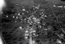
 View from the east |
|
| Location of the municipality | |
  |
|
Sins ( Swiss German : [ seis ]) is a municipality in the Swiss canton of Aargau . It belongs to the Muri district and is located in the Reuss Valley , on the border with the cantons of Zug and Lucerne . With over twenty square kilometers, Sins is the second largest municipality in the canton in terms of area. Meienberg was the official name of the community until 1941 .
geography
The community consists of several villages and hamlets as well as individual farms scattered across the entire municipality. The main settlement of Sins, in which around two thirds of all residents live, is just under half a kilometer from the western bank of the Reuss . A little higher on the eastern slope of the moraine hill Totrist ( 495 m above sea level ) is an extensive new housing estate . About two kilometers north of Sins is the village of Reussegg ( 404 m above sea level ) on the Reuss . About one and a half kilometers west-northwest is Meienberg ( 456 m above sea level ).
From here on, the terrain, divided by numerous stream valleys, rises to the ridge of the Lindenberg . About two and a half kilometers from Sins is the village of Alikon ( 526 m above sea level ). The village of Aettenschwil ( 491 m above sea level ) is located almost two kilometers west-southwest of Sins , halfway to Abtwil . Two kilometers west of it, on the eastern slope of the Lindenberg, is the hamlet of Holderstock ( 607 m above sea level ). South of Aettenschwil begins an area strip over four kilometers long and up to one and a half kilometers wide between the communities of Abtwil, Dietwil and Oberrüti . At the northern end, directly on the border with Oberrüti, is the hamlet of Winterhalden ( 469 m above sea level ), close to each other in the middle the village of Fenkrieden ( 499 m above sea level ) and the hamlet of Chrüzstross ( 493 m above sea level) . ) and Gärischwil ( 501 m above sea level ). The terrain rises slightly to the Sulzberg ( 541 m above sea level ) in the very south.
The area of the municipality is 2031 hectares , of which 358 hectares are forested and 213 hectares are built over. The highest point of the community is at 750 m above sea level. M. the ridge of the Lindenberg, the deepest at 390 m above sea level. M. on the Reuss. The longest north-south extension is 8.5 kilometers, the longest east-west extension 5.5 kilometers. Neighboring communities are Auw and Mühlau in the north, Hünenberg in the east, Oberrüti and Dietwil in the south-east, Inwil in the south, Ballwil in the south-west and Abtwil and Hohenrain in the west.
history
Sins was first mentioned in 1230, Alikon as early as 893 ( Halahinchova ), Reussegg around 1130 ( Ruseca ), Aettenschwil in 1179 ( Agetiswilare ) and Fenkrieden around 1300 ( Venchrieden ). The place name Sins comes from the Gallo-Roman Sentias and means "by the ways". Around 1230 the Habsburgs founded the town of Meienberg ( Meienberch ). The fortified town was plundered and burned down by the Confederates in 1386 during the Sempach War . Due to the lack of an economic basis, Meienberg could never recover from this blow and sank into a hamlet, but remained the place of the court. The economic and political center of the community then moved to Sins.

In 1415 Lucerne conquered the Meienberg office , but in 1425 had to return it to the common property of the Confederates . The free offices were formed from the conquered areas , a common rule . Sins belonged together with Auw , Beinwil (without Winterschwil), Abtwil , Oberrüti and Dietwil to the Meienberg district. The area of today's municipality (with the exception of Meienberg) belonged in the Middle Ages to the Lords of Reussegg, who owned a small residential tower there . In the 15th century the fiefdom and thus the lower jurisdiction passed to the citizens of Lucerne and finally to the city of Lucerne. At least since 1246 there was a ferry across the Reuss in Sins . In 1640/41 Zug built the Sins – Hünenberg bridge over the Reuss .
During the Second Villmerger War , Sins battled around the bridge and the parish church on July 20, 1712 , when the Catholic Central Swiss drove out the Reformed Bernese. The battle claimed around 500 deaths, but the victory was ultimately meaningless, as the central Swiss lost the decisive Second Battle of Villmergen five days later . In March 1798 the French took Switzerland and proclaimed the Helvetic Republic . Sins belonged to the Muri district in the short-lived canton of Baden , since 1803 it has been a municipality of the new canton of Aargau. On November 10, 1847, Zug's troops destroyed half of the bridge in the Sonderbund War in order to stop the advance of Dufour's troops. This measure proved ineffective, as Zug surrendered to the liberal forces two weeks later. An emergency bridge was built and the eastern part was restored by 1852.

On December 1, 1881, with the opening of the last stage of the Aargau Southern Railway , Sins was connected to the railway network. A year later there was a direct connection to the Gotthard Railway in nearby Rotkreuz . 1940, the first industrial company settled down, an aluminum plant of Lonza . On October 1, 1941, the municipality changed its name from Meienberg to Sins to express the growing importance of this district. Since the beginning of the 20th century, the population has shown constant growth, with the exception of a phase of stagnation in the 1950s.
The centuries-old Reuss Bridge could no longer cope with the increasing traffic, together with the subsequent level crossing it formed a bottleneck. After almost three years of construction, a new bridge was opened south of it in 1996; the old bridge has since been reserved for pedestrians and cyclists. The municipality of Sins was also affected by the heavy rainy days in September 2004. The old wooden bridge got away with slight damage. In the small hamlet of Reussegg, however, agricultural areas on the Reuss were largely flooded. In the following year, construction work was carried out in the neighboring community of Hünenberg to prevent further flooding on both sides of the Reuss in the future.
Attractions

A little north of the village center of Sins is the former church district on an elevated terrain. The baroque are preserved parish church Nativity of Mary (built from 1744 to 1748) and built in 1726 Municipal House , which served as a parsonage until 1,953th The place Meienberg shows in places the origin as a medieval fortified town. It lies on a crescent-shaped hill and has remains of a city wall and a moat. The office building , which dates from the Middle Ages, was rebuilt in 1575 and received its current appearance in 1765.
Several of the parish's smaller villages have a chapel. These are the Eligius Chapel in Meienberg (built 1553), the Verena Chapel in Aettenschwil (built 1574/75), the Andreas Chapel in Holderstock (built 1665), the Wendelins Chapel in Fenkrieden (built 1684, enlarged 1844), the Jost and Antonius Chapel in Alikon (built 1756) and the Fourteen Helpers Chapel in Gärischwil from the first half of the 18th century.
coat of arms
The blazon of the municipal coat of arms reads: "In white on a green three-mountain, three red, yellow roses with green sepals, stems and leaves." The coat of arms is derived from the banner of the Meienberg office, which was awarded in 1531. The coat of arms of the Meienberg office showed a green linden tree on a hill on a white background. Until 1821 an unspecified tree was depicted, which was then replaced by three roses. It is a “talking” coat of arms and represents a “Meien” (meadow), which in turn refers to the old town of Meienberg.
population
The population developed as follows:
| year | 1803 | 1850 | 1900 | 1930 | 1950 | 1960 | 1970 | 1980 | 1990 | 2000 | 2010 |
| Residents | 1,136 | 1,788 | 1,480 | 1,689 | 2,160 | 2,195 | 2,435 | 2,625 | 2,956 | 3,282 | 4,055 |
On December 31, 2019, 4,290 people lived in Sins, the proportion of foreigners was 19.4%. In the 2015 census, 60.3% described themselves as Roman Catholic and 10.9% as Reformed ; 28.8% were non-denominational or of other faiths. 92.7% stated German as their main language in the 2000 census , 2.0% Serbo-Croatian , 1.3% Albanian , 0.9% Portuguese , 0.7% each Italian and Turkish .
Politics and law
The assembly of those entitled to vote, the municipal assembly , exercises legislative power. The executing authority is the five-member municipal council . He is elected by the people in the majority procedure, his term of office is four years. The parish council leads and represents the parish. To this end, it implements the resolutions of the municipal assembly and the tasks assigned to it by the canton. The District Court of Muri is primarily responsible for legal disputes . Sins belongs to the Friedensrichterkreis XIII (Muri).
economy
According to the company structure statistics (STATENT) collected in 2015, there are around 2,300 jobs in Sins, of which 12% are in agriculture, 37% in industry and 51% in the service sector. The most important branches of industry are steel processing and the production of foams. 3A Composites (formerly Airex AG) is a major company based in Sins . A large number of employees work in the agglomerations of the cities of Zug and Lucerne .
traffic

Sins is the intersection of Hauptstrasse 25 ( Lenzburg - Zug ) and Kantonsstrasse 296 from Bremgarten to Lucerne . The next motorway connection to the A14 is two kilometers east of the village center near Cham, after passing the Sins-Hünenberg bridge over the Reuss . Sins has a train station on the SBB line Lenzburg - Arth-Goldau ( Aargau Southern Railway ). Bus routes operated by Zugerland Verkehrsbetriebe run from the train station to Gisikon-Root, Auw and Cham . On weekends there is a night bus from Zug via Sins and Muri to Mühlau .
education
The municipality has all levels of compulsory elementary school ( primary school , secondary school , secondary school , district school ). There are four kindergartens and three school houses in Sins . There is also a primary school and a kindergarten in the village of Aettenschwil, and there was an additional primary school in Alikon until summer 2016. The closest grammar school is the Cantonal School in Wohlen .
Personalities
- Peter Suter (1808–1884), Member of the Government and National Council
- Eugen Kuhn (1895–1970), type artist
- Karl Kennel (1929–1998), veterinarian and politician
- René Villiger (1931–2010), graphic artist and painter
- Kaspar Villiger (* 1941), manufacturer and former Federal Councilor
- Beat Villiger (* 1957), member of the government
- Simonetta Sommaruga (* 1960), Federal Councilor
literature
- Anton Wohler: Sins. In: Historical Lexicon of Switzerland .
- Georg Germann : The art monuments of the canton Aargau . Ed .: Society for Swiss Art History . Volume V: The Muri District. Birkhäuser Verlag, Basel 1967, DNB 457321970 .
Web links
- Official website of the municipality of Sins
- Meienberg - A place and gender of the same name (family chronicle and local history)
Individual evidence
- ↑ Cantonal population statistics 2019. Department of Finance and Resources, Statistics Aargau, March 30, 2020, accessed on April 2, 2019 .
- ↑ Cantonal population statistics 2019. Department of Finance and Resources, Statistics Aargau, March 30, 2020, accessed on April 2, 2019 .
- ↑ a b Beat Zehnder: The community names of the canton of Aargau . In: Historical Society of the Canton of Aargau (Ed.): Argovia . tape 100 . Verlag Sauerländer, Aarau 1991, ISBN 3-7941-3122-3 , p. 397-399 .
- ↑ a b National map of Switzerland, sheets 1130 and 1131, Swisstopo.
- ↑ Standard area statistics - municipalities according to 4 main areas. Federal Statistical Office , November 26, 2018, accessed on May 10, 2019 .
- ^ A b Germann: The art monuments of the Canton of Aargau, Volume V: District of Muri.
- ^ Joseph Galliker, Marcel Giger: Municipal coat of arms of the Canton of Aargau . Lehrmittelverlag des Kantons Aargau, book 2004, ISBN 3-906738-07-8 , p. 277 .
- ↑ Population development in the municipalities of the Canton of Aargau since 1850. (Excel) In: Eidg. Volkszählung 2000. Statistics Aargau, 2001, archived from the original on October 8, 2018 ; accessed on May 8, 2019 .
- ↑ Resident population by religious affiliation, 2015. (Excel) In: Population and Households, Community Tables 2015. Statistics Aargau, accessed on May 10, 2019 .
- ↑ Swiss Federal Census 2000: Economic resident population by main language as well as by districts and municipalities. (Excel) Statistics Aargau, archived from the original on August 10, 2018 ; accessed on May 8, 2019 .
- ↑ circles of justice of the peace. Canton of Aargau, accessed on June 20, 2019 .
- ↑ Statistics of the corporate structure (STATENT). (Excel, 157 kB) Statistics Aargau, 2016, accessed on May 8, 2019 .
Abtwil | Aristau | Auw | Beinwil (Freiamt) | Besenbüren | Bettwil | Boswil | Coins | Buttwil | Dietwil | Geltwil | Kallern | Merenschwand | Mühlau | Muri | Oberrüti | Rottenschwil | Sins | Waltenschwil
Former municipality: Benzenschwil | Forest houses | Will
Canton of Aargau | Districts of the Canton of Aargau | Municipalities in the Canton of Aargau