
Animal heads
| coat of arms | Germany map | |
|---|---|---|

|
Coordinates: 48 ° 34 ' N , 10 ° 55' E |
|
| Basic data | ||
| State : | Bavaria | |
| Administrative region : | Swabia | |
| County : | augsburg | |
| Height : | 430 m above sea level NHN | |
| Area : | 39.17 km 2 | |
| Residents: | 4043 (Dec. 31, 2019) | |
| Population density : | 103 inhabitants per km 2 | |
| Postal code : | 86672 | |
| Primaries : | 08271, 08276 | |
| License plate : | A , SMÜ, WHO | |
| Community key : | 09 7 72 207 | |
| LOCODE : | DE THR | |
| Market structure: | 8 parts of the community | |
Market administration address : |
Marktplatz 1 86672 Thierhaupten |
|
| Website : | ||
| Mayor : | Anton Brugger ( CSU ) | |
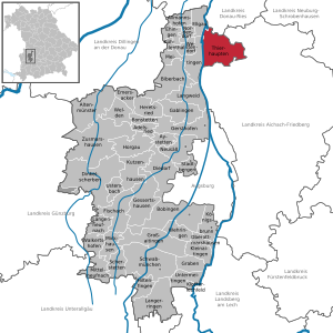
| Location of the Thierhaupten market in the Augsburg district | ||
  |
||


Thierhaupten is a market in the Augsburg district , which is east of the Lech and is therefore the only municipality in the Swabian district that belongs to the Bavarian dialect area.
geography
Geographical location and geology
Thierhaupten is located on the eastern Lechleite almost exactly between Augsburg and Donauwörth . The lower village is located in the Lech Valley, while the upper village is already in the hill country. The districts of Ötz and Altenbach are in the Lech plane, Königsbrunn partly also on the Lechleite , Neukirchen , Weiden, Hölzlarn and Sparmannseck in the hill country. In the west, the municipality borders on the Lech , which, however, does not affect the village. The Friedberger Ach flows through Thierhaupten from south to north. The Bitz comes from the Weidener Tal in the southeast and flows into the Friedberger Ach in Thierhaupten. The Friedberger Ach divides south of Thierhauptens into the Lüßgraben and Mühlgraben, which reunite within the village. In 2007 it was decided to build a flood retention basin and a dam on the Friedberger Ach in the southern municipal area, in order to reduce or prevent the risk of flooding to the place in the future. The Lech is also surrounded by dams in the direction of Thierhaupten after the Whitsun floods in 1999 almost led to a catastrophe.
The highest point in Thierhaupten is the Kühberg (499.1 m above sea level) in the Neukirchen district . The location Thierhaupten itself is dominated by cross Berg (478.7 m NN) of the conservation area cross bei Thierhaupten forms. The Wünschberg (453.7 m NN) north of Neukirchen and the Eselsberg (483.7 m NN) south of Thierhaupten are also striking .
In terms of natural space, Thierhaupten belongs to the Danube-Iller-Lech-Platte , which in turn is part of the Alpine foothills , one of the main natural units in Germany . The municipality of Thierhaupten is in turn divided between the natural subunits Lechtal and Aindlinger Terrassentreppe .
In the Lech Valley, the soils consist of deposits of post-glacial gravel in a wide box valley . These river terraces consist of the so-called low terraces and high terraces . The lower terraces in Thierhaupten are overgrown with floodplains and the characteristic heaths with limestone grassland and litter meadow plant communities. The Lech is accompanied to the east by a band of alluvial forest (which, together with the Altnet, forms the Lechauen von Thierhaupten nature reserve ), otherwise the Lech plain in Thierhaupten is largely free of forests, interspersed with individual hedges and woods. The Lechtalheiden under protection include the Thierhauptener Heide and the Ötzer Heide . The high terraces, the height difference of which can be 8-10 meters from the low terraces, are covered with loess and merge into the hilly landscape of the Aindlinger terrace stairs.
The villages of Thierhaupten and Königsbrunn are framed by large forest areas (from north to south: Brand , Neukirchner Holz, Wolfschlag, Thierhauptner Holz, Ziegelberg, Edenhauser Forst) towards the hill country of the Aindlinger terrace stairs. Behind it rises the Kühberg with Neukirchen, the east side of which opens into the valley of the Kleine Paar , flanked by Weiden, Hölzlarn and Sparmannseck. Here in the hill country the loess layer is very thick, which is why the area is very suitable for agriculture.
Neighboring communities
- Aindling ( district of Aichach-Friedberg ) with the districts of Edenhausen , Eisingersdorf and Pichl
- Baar (Aichach-Friedberg district) with the districts of Unterbaar , Oberbaar and Heimpersdorf
- Ellgau (Augsburg district)
- Meitingen (Augsburg district) with the districts of Meitingen and Waltershofen
- Münster (Donau-Ries district) with the Hemerten district
- Pöttmes (district of Aichach-Friedberg) with the district of Osterzhausen
- Todtenweis (district of Aichach-Friedberg) with the districts of Bach and Sand
Community structure
The municipality consists of 2 districts and has 8 officially named municipality parts :
- Main town and district Thierhaupten with the hamlets of Altenbach, Königsbrunn, Ötz and Weiden
- Parish village and district Neukirchen with the village of Hölzlarn and the wasteland of Sparmannseck. The Wieskapelle is located in the district .
history
Until the 19th century
The name indicates an originally Germanic settlement that probably had the heads of animals (animal heads → Thierhaupten) erected. In 1776 a sandstone animal head was unearthed, which can serve as further evidence.
According to a legend, about 750 was at this place by the Bavarian Agilolfinger Duke Tassilo III. the thierhaupten abbey founded. He is said to have got lost in the area during a hunt and, according to a vow, had a monastery built as a thank you at the place where he found his entourage. According to legend, a doe ( hunter's language : animal = doe) showed him the way and that is why a doe is still depicted in the center of the Thierhaupten coat of arms.
In 955 the battle took place on the Lechfeld , of which many individual battles took place east of the Lech between Thierhaupten and Mering . A relic from this time are the remains of the ramparts on Eselsberg , which are part of a chain of Hungarian ramparts .
The Benedictine monastery , one of the oldest in Bavaria, played an important role in the area. In the Middle Ages, the monastery was granted lower jurisdiction, which secured the monastery basic administrative sovereignty. The place was also given market rights with which annual and livestock markets could be held. Numerous centuries-old buildings bear witness to this long history. Around 1600 the judges house (since 1834 parsonage) and a school (now an inn) were built. As a replacement for the Romanesque village church St. Georg (already mentioned in a document in 1334) a new larger village church St. Georg was built in 1599, which was demolished in 1819. The oldest building is the abbey church of St. Peter and Paul , built in 1170 . It became a parish church in 1812 . In 1803, the monastery itself came into private ownership through secularization , and the forests that had formerly belonged to the monastery were secured by the Bavarian state. The last abbot Edmund Schmid bought the monastery church and donated it to the community. The market town was then able to purchase the remaining former monastery buildings in 1983 and has since then fundamentally renovated the structure.
Over the centuries Thierhaupten suffered repeated war-related damage. For example during the Hungarian invasions in the 10th century or in the Thirty Years War . The community was also badly hit during World War II .
District affiliation
The Thierhaupten market belonged to the district of Neuburg an der Donau and, as part of the district reform on July 1, 1972, was assigned to the Augsburg-West district, which was given the current name of Augsburg district on May 1, 1973 .
Incorporations
On May 1, 1978 the then independent communities Baar (Swabia) (with Oberbaar , Unterbaar and Dürnberg), Heimpersdorf (with Lechlingszell, Oberperlmühle and Unterperlmühle) and Neukirchen (with Hölzlarn and Sparmannseck) as well as the districts Altenbach and Königsbrunn were incorporated into the municipality of Münster .
Outsourcing
On January 1st, 1994 Baar (Swabia) gained its independence and became independent again. After a public vote, Heimpersdorf also moved to the newly founded municipality of Baar (Swabia) on January 1, 1994 .
Population development
Between 1988 and 2018 the market grew from 3,836 to 3,993 by 157 inhabitants or 4.1%. The spin-off of Baar in 1994 must be taken into account.
politics
Municipal council
The municipal council consists of the 1st mayor and 16 councilors.
| Parties | 2020 | |
|---|---|---|
| proportion of | Seats | |
| CSU | 35.4% | 6th |
| Free voters | 23.7% | 4th |
| SPD | 13.8% | 2 |
| JBU | 15.4% | 2 |
| UB | 8.2% | 1 |
| JFW | 3.5% | 1 |
(Status: local elections 2020 ) Compared to the local elections of 2014, the Independent Citizens (UB) lost a seat that fell to the Young Free Voters (JFW), who were running for the first time.
Mayor has been Anton Brugger (CSU) since 2014; he was confirmed in office on March 15, 2020 with 67.1% of the votes.
Previous mayor (since 1946)
- Edmund Hölzl (1946–1949)
- Xaver Brugger (1949–1969)
- Heinrich Schieder (1969–1978)
- Fritz Hölzl (1978–1996)
- Franz Neher (1996-2014)
- Anton Brugger (since 2014)
coat of arms
Blazon : Under the shield head with the Bavarian diamonds in blue the body of a red-tongued golden doe.
Culture and sights

Museums
- Local history and costume museum
- Monastery mill museum, with grinding mills, a rag pounding mill, an oil mill and a model of a sawmill.
Buildings
- Thierhaupten Monastery , former Benedictine monastery
- Monastery church of St. Peter and Paul in Thierhaupten
- Parish Church of St. Vitus in Neukirchen
Regular events
- Festwoche Thierhaupten , an annual folk festival that culminates in a procession with horse-drawn flower carriages; usually five to six days around August 15; the local clubs take turns organizing the festival week.
- Leonhardiritt Hölzlarn
- Craftsman's yard with garden party in the Thierhaupten monastery complex; The organizer is the local fruit and horticultural association .
- The music association's garden party usually takes place a week before the fruit and horticultural association's.
- Fishing festival of the fishing association in the monastery cowshed, with many regional fish specialties, mostly in one of the first two weeks of November.
Economy and Infrastructure
Jobs
There are 1,092 jobs subject to social security contributions in the municipality, 673 of them in the manufacturing industry (as of 2017).
traffic
The state road St 2045 ("Meitinger Straße") goes through Thierhaupten and leads from the west (Meitingen, motorway-like B 2) via Thierhaupten to Baar (Swabia) and Pöttmes and further east. In January 2009, the previous district road A 25 was upgraded to State Road St 2381 due to increased traffic (“Baarer Straße”, parts of “Herzog-Tassilo-Straße”, “Augsburger Straße”). This leads from the St 2047 (Rain am Lech) via Thierhaupten to the south (Affing-Mühlhausen), where it joins the St 2035 . Due to the new route of the Romantic Road between Donauwörth and Augsburg on the old Bavarian side of the Lech via Thierhaupten instead of the B 2 on the Swabian side, Thierhaupten is also on this important route, which the place hopes to provide tourist impulses.
In town, Thierhaupten suffers from a high traffic load, which is mainly due to the fact that after the Thierhaupten-Meitinger Lech Bridge there is no bridge over the Lech about 20 km to the north, which is why all traffic from the triangle Meitingen - Rain - Pöttmes drives over this bridge to go south or west. The same applies to the Swabian side in the opposite direction.
From the St 2381 (Augsburger Straße) the district road A 26 leads over the district Neukirchen to the district border to the district Aichach-Friedberg before Osterzhausen , where it continues as AIC 31 .
Established businesses
The bus company Egenberger Reisen has its headquarters in Thierhaupten.
education
- Academy for advanced training for craftsmen
- Bavarian building archive
- Thierhaupten community library
- Elementary and middle school Thierhaupten
- Thierhaupten youth leisure center
- Kindergarten Neukirchen
- Kindergarten St. Peter and Paul Thierhaupten
- School of Village and Rural Development Thierhaupten
literature
- Little art guide No. 829: Thierhaupten by Hugo Schnell, Schnell & Steiner (1966).
- Topographic maps of Bavaria, p. 7431: Thierhaupten Bavarian State Surveying Office (1988).
- My Thierhaupten Poems by Gerlinde Ortegel Rita Fischer, (1998).
- History, restoration and current use of the Thierhaupten Monastery. Permanent exhibition of the homeland maintenance of the Swabian district. Catalog. by Peter Fassl, Swabia District (2000).
- Animal heads. Former Benedictine monastery of Karin Hösch, Gregor Peda (Illustr.), Peda Art Publishing (2001).
- St. Peter and Paul Thierhaupten, former Benedictine abbey church, today Catholic. Parish church by Gertrud Roth-Bojadzhiev and Anton Brandl, Schnell & Steiner (2005).
- The oide Hos by Adalbert Mayr.
- View through the fence by Adalbert Mayr (2000).
- Adalbert Mayr's half-time (2005).
Web links
- Entry on the coat of arms of Thierhaupten in the database of the House of Bavarian History
- Thierhaupten: Official statistics of the LfStat (PDF; 1.23 MB)
- School of Village and Rural Development Thierhaupten
Individual evidence
- ↑ "Data 2" sheet, Statistical Report A1200C 202041 Population of the municipalities, districts and administrative districts 1st quarter 2020 (population based on the 2011 census) ( help ).
- ^ Community in the local database of the Bavarian State Library Online . Bavarian State Library, accessed on August 19, 2019.
- ^ Federal Statistical Office (ed.): Historical municipality directory for the Federal Republic of Germany. Name, border and key number changes in municipalities, counties and administrative districts from May 27, 1970 to December 31, 1982 . W. Kohlhammer, Stuttgart / Mainz 1983, ISBN 3-17-003263-1 , p. 767 and 768 .
- ↑ StBA: Changes in the municipalities in Germany, see 1994

Neukirchen with Hölzlarn, Sparmannseck and Wieskapelle | Thierhaupten with Altenbach, Königsbrunn, Ötz and Weiden

Adelsried | Allmannshofen | Altenmünster | Aystetten | Biberbach | Bobingen | Bonstetten | Diedorf | Spelled shards | Ehingen | Ellgau | Emersacker | Fischach | Gablingen | Gersthofen | Gessertshausen | Dig | Großaitingen | Heretsried | Hiltenfingen | Horgau | Kleinaitingen | Klosterlechfeld | Koenigsbrunn | Kühlenthal | Kutzenhausen | Langenneufnach | Langerringen | Langweid am Lech | Meitingen | Mickhausen | Mittelneufnach | Neusäß | Nordendorf | Oberottmarshausen | Scherstetten | Schwabmünchen | Stadtbergen | Heads of animals | Untermeitingen | Ustersbach | Walkertshofen | Wehringen | Welden | Westendorf | Zusmarshausen
Unregulated areas: Schmellerforst