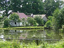
Wilczyny
| Wilczyny | ||
|---|---|---|

|
|
|
| Basic data | ||
| State : | Poland | |
| Voivodeship : | Warmia-Masuria | |
| Powiat : | Kętrzyn | |
| Gmina : | Srokovo | |
| Geographic location : | 54 ° 15 ' N , 21 ° 29' E | |
| Residents : | 78 (March 31, 2011) | |
| Postal code : | 11-420 | |
| Telephone code : | (+48) 89 | |
| License plate : | NKE | |
| Economy and Transport | ||
| Street : | Srokowo / ext. 650 - Srokowski Dwór ↔ Łęknica - Asuny | |
| Jegławki - Wilcza Wólka → Wilczyny | ||
| Marszałki - Osikowo → Wilczyny | ||
| Rail route : | no rail connection | |
| Next international airport : | Danzig | |
| Administration (as of 2009) | ||
| Mayor : | Małgorzata Dwulat | |
Wilczyny [ vilˈt͡ʂɨnɨ ] ( German Wolfshagen ) is a village in Poland in the Warmian-Masurian Voivodeship . The place forms a Schulzenamt ( Polish Sołectwo ) in the rural community Srokowo ( Drengfurth ) in the powiat Kętrzyński ( Rastenburg district ).
Geographical location
The village is located in northern Poland, about seven kilometers south of the state border with the Russian Kaliningrad Oblast . The Omet flows through the village and the Schwarzes Fließ brook on the banks of the river .
history
Local history
Wolfshagen , around 1819 Wolfhagen , was laid out in 1403 according to Kulmer law on an area of 54 hooves . In 1785 there were 20 fireplaces in the "royal village with the seat of a royal forestry office", the number of which had grown to 43 by 1818.
1874 Wolf Hagen was in the newly built office district Jäglack ( Polish Jegławki ) incorporated, which existed until 1945 and the county Rastenburg in the administrative district of Kaliningrad in the Prussian province of East Prussia belonged.
In 1945, at the end of World War II , the Red Army marched into the area. As a result of the war, Wolfshagen became part of the People's Republic of Poland as Wilczyny .
Population numbers
Below is the graphic representation of the population figures.

Schulzenamt Wilczyny
For Schulz Office Wilczyny in Gmina Srokowo ( German Drengfurth ) include the towns Jegławki (Jäglack) , Stare Jegławki (Alt Jäglack) , Kolkiejmy (Kollkeim) , Mintowo (Mintwiese) , Osikowo (Leitner Walde) , Skandławki (Skandlack) , Wilcza Wólka (Friedrich Berg ) and Wilcze (Waldhaus Drengfurth) .
church
Until 1945 Wolfshagen was parish in the Evangelical Parish Church of Drengfurth in the church province of East Prussia of the Church of the Old Prussian Union and in the Catholic Church of St. Katharina in Rastenburg with the Drengfurth chapel in what was then the Diocese of Warmia .
Today Wilczyny belongs to the Catholic parish Srokowo in the current Archdiocese of Warmia and to the Evangelical Church Srokowo , a branch church of the Johanneskirche Kętrzyn in the Diocese of Masuria of the Evangelical-Augsburg Church in Poland .
traffic
The village of Wilczyny is not on any major road. The voivodeship road 650 runs about three kilometers to the south , connecting Srokowo with Kętrzyn (Rastenburg) or Węgorzewo (Angerburg) and Gołdap (Goldap) . A road runs through the village itself from Srokowo, five kilometers south-east, to Asuny (Assaunen) , ten kilometers north-west , as well as a road from Osikowo (Leitnerswalde) to Wilczyny.
The place does not have its own rail connection. The nearest train station is 20 kilometers south in Kętrzyn , where there are direct connections to Korsze (Korschen) and Białystok .
The closest international airport is Kaliningrad Airport , which is about 90 kilometers northwest on Russian territory outside the European Union . The nearest international airport on Polish territory is Lech Wałęsa Airport in Gdansk, about 195 kilometers to the west .
Web links
literature
- Tadeusz Swat: Dzieje Wsi . In: Aniela Bałanda u. a .: Kętrzyn. Z dziejów miasta i okolic . Pojezierze, Olsztyn 1978, p. 238 ( Seria monografii miast Warmii i Mazur ).
Footnotes
- ^ CIS 2011: Ludność w miejscowościach statystycznych według ekonomicznych grup wieku (Polish), March 31, 2011, accessed on June 29, 2017
- ↑ Polish Postal Code Directory 2013, p. 1455
- ↑ a b Sołectwa Gminy Srokowo , website of Gmina Srokowo, accessed on December 25, 2009
- ↑ Kętrzyn: Z dziejów miasta i okolic , Olsztyn 1978, p. 19
- ↑ Dietrich Lange, Geographical Location Register East Prussia (2005): Wolfshagen
- ↑ a b Wolfshagen (Rastenburg district) at GenWiki
- ^ Tadeusz Swat: Dzieje Wsi in Kętrzyn: Z dziejów miasta i okolic , Olsztyn 1978, p. 238
- ^ Rolf Jehke, Jäglack district
-
↑ For 1818, May 1939, 1970: Tadeusz Swat: Dzieje Wsi . In: Kętrzyn: Z dziejów miasta i okolic , Olsztyn 1978, p. 238
For 1905: Community encyclopedia Kingdom of Prussia I, Book I East Prussia, based on the materials of the census of December 1, 1905, ISBN 3-931577-26-0 , here after genealogy.net
For 2007: genealogy.net, Wolfshagen, Wilczyny , accessed December 25, 2009 - ↑ Walther Hubatsch , History of the Protestant Church in East Prussia , Volume 3 Documents , Göttingen 1968, p. 473


