Vilamaniscle: Difference between revisions
update mayor |
Tom.Reding (talk | contribs) m +{{Authority control}} (1 ID from Wikidata), WP:GenFixes on |
||
| (16 intermediate revisions by 9 users not shown) | |||
| Line 7: | Line 7: | ||
| image_flag = |
| image_flag = |
||
| flag_alt = |
| flag_alt = |
||
| image_seal = |
| image_seal = Escudo_de_Vilamaniscle_(Gerona).svg |
||
| seal_alt = |
| seal_alt = |
||
| image_shield = |
| image_shield = |
||
| Line 16: | Line 16: | ||
| map_alt = |
| map_alt = |
||
| map_caption = |
| map_caption = |
||
| pushpin_map = Spain |
| pushpin_map = Spain Province of Girona#Spain |
||
| pushpin_label_position = |
| pushpin_label_position = |
||
| pushpin_map_alt = |
| pushpin_map_alt = |
||
| pushpin_map_caption = Location in Catalonia |
| pushpin_map_caption = Location in Catalonia |
||
| coordinates = {{coord|42|22|N|3|4|E|display=inline,title}} |
|||
| latd = 42 |latm = 22 |lats = |latNS = N |
|||
| longd = 3 |longm = 4 |longs = |longEW = E |
|||
| coor_pinpoint = |
| coor_pinpoint = |
||
| coordinates_type = |
|||
| coordinates_display = inline,title |
|||
| coordinates_footnotes = |
| coordinates_footnotes = |
||
| coordinates_region = |
|||
| subdivision_type = [[List of sovereign states|Country]] |
| subdivision_type = [[List of sovereign states|Country]] |
||
| subdivision_name = {{flag|Spain}} |
| subdivision_name = {{flag|Spain}} |
||
| Line 43: | Line 39: | ||
| leader_party = |
| leader_party = |
||
| leader_title = [[Mayor]] |
| leader_title = [[Mayor]] |
||
| leader_name = Ramon Bonaterra Moltó (2015)<ref name=municat>{{cite web|url=http://municat.gencat.cat/index.php?page=consulta&mostraEns=1722720002|title=Ajuntament de Vilamaniscle|publisher=[[Generalitat of Catalonia]]| |
| leader_name = Ramon Bonaterra Moltó (2015)<ref name=municat>{{cite web|url=http://aplicacions.municat.gencat.cat/index.php?page=consulta&mostraEns=1722720002|title=Ajuntament de Vilamaniscle|publisher=[[Generalitat of Catalonia]]|access-date=2015-11-13}}</ref> |
||
| unit_pref = Metric |
| unit_pref = Metric |
||
<!-- ALL fields with measurements have automatic unit conversion --> |
<!-- ALL fields with measurements have automatic unit conversion --> |
||
<!-- for references: use <ref> tags --> |
<!-- for references: use <ref> tags --> |
||
| area_footnotes = <ref name=idescat>{{cite web|url=http://www.idescat.cat/emex/?lang=en&id=172272|title=El municipi en xifres: Vilamaniscle|publisher=[[Institut d'Estadística de Catalunya|Statistical Institute of Catalonia]]|access-date=2015-11-23}}</ref> |
|||
| area_footnotes = |
|||
| area_urban_footnotes = <!-- <ref> </ref> --> |
| area_urban_footnotes = <!-- <ref> </ref> --> |
||
| area_rural_footnotes = <!-- <ref> </ref> --> |
| area_rural_footnotes = <!-- <ref> </ref> --> |
||
| Line 58: | Line 54: | ||
| area_blank2_title = |
| area_blank2_title = |
||
<!-- square kilometers --> |
<!-- square kilometers --> |
||
| area_total_km2 = |
| area_total_km2 = 5.5 |
||
| area_land_km2 = |
| area_land_km2 = |
||
| area_water_km2 = |
| area_water_km2 = |
||
| Line 69: | Line 65: | ||
| elevation_footnotes = |
| elevation_footnotes = |
||
| elevation_m = |
| elevation_m = |
||
| population_as_of = {{Spain metadata Wikidata|population_as_of}} |
|||
| population_footnotes = |
|||
| population_footnotes = {{Spain metadata Wikidata|population_footnotes}} |
|||
| population_total = |
|||
| population_total = {{Spain metadata Wikidata|population_total}} |
|||
| population_as_of = |
|||
| population_density_km2 = auto |
| population_density_km2 = auto |
||
| population_demonym = |
| population_demonym = |
||
| population_note = |
| population_note = |
||
| timezone1 = [[Central European Time|CET]] |
|||
| utc_offset1 = +1 |
|||
| timezone1_DST = [[Central European Summer Time|CEST]] |
|||
| utc_offset1_DST = +2 |
|||
| postal_code_type = |
| postal_code_type = |
||
| postal_code = |
| postal_code = |
||
| Line 84: | Line 76: | ||
| area_code = |
| area_code = |
||
| iso_code = |
| iso_code = |
||
| website = {{URL| |
| website = {{URL|www.vilamaniscle.cat}} |
||
| footnotes = |
| footnotes = |
||
}} |
}} |
||
'''Vilamaniscle''' is a [[municipalities of Spain|municipality]] in the ''[[comarca]]'' of [[Alt Empordà]], [[Girona (province)|Girona]], [[Catalonia]], |
'''Vilamaniscle''' is a [[municipalities of Spain|municipality]] in the ''[[Comarques of Catalonia|comarca]]'' of [[Alt Empordà]], [[Girona (province)|Girona]], [[Catalonia]], Spain. It is located in the western part of the ''Serra de la Baga d'en Ferràn'', a branch of the [[Albera Range]]. Much of its municipal term is covered with [[pine]] and [[cork oak]] trees. The main crops are [[olive]]s and [[grape]]s. Local wine is appreciated all over the country. New hosting services are growing due to tourism. |
||
Vilamaniscle is the home for around 120 inhabitants today. The village is a varied picture of some restored homes, other in the process of restoration and still others that wait for their renovation. The majority of the houses were built between the 17th and 19th century. Vilamaniscle is dominated by the "Castell", a three-level unrestored building whose origin is difficult to date. In the prehistoric time people probably lived here, the evidence being the three-metres-high menhir "Pedra Dreta" which is very close to Vilamaniscle. |
Vilamaniscle is the home for around 120 inhabitants today. The village is a varied picture of some restored homes, other in the process of restoration and still others that wait for their renovation. The majority of the houses were built between the 17th and 19th century. Vilamaniscle is dominated by the "Castell", a three-level unrestored building whose origin is difficult to date. In the prehistoric time people probably lived here, the evidence being the three-metres-high menhir "Pedra Dreta" which is very close to Vilamaniscle. |
||
==References== |
==References== |
||
{{ |
{{Reflist}} |
||
== External links == |
== External links == |
||
*[http://www.vilamaniscle.org Town Hall webpage] |
*[http://www.vilamaniscle.org Town Hall webpage] |
||
*[http:// |
* [http://aplicacions.municat.gencat.cat/index.php?page=consulta&mostraEns=1722720002 Government data pages] {{in lang|ca}} |
||
*[http://www.idescat.cat/territ/BasicTerr?TC=3&V0=1&V1=17227 Informació de l'Institut d'Estadística de Catalunya] |
|||
{{br}} |
|||
{{Geographic location |
{{Geographic location |
||
|Centre = Vilamaniscle |
|Centre = Vilamaniscle |
||
| Line 111: | Line 101: | ||
|NW = [[Rabós]] |
|NW = [[Rabós]] |
||
}} |
}} |
||
| ⚫ | |||
{{Spain-geo-stub}} |
|||
{{Alt Emporda}} |
{{Alt Emporda}} |
||
{{Municipalities in Girona|state=autocollapse}} |
{{Municipalities in Girona|state=autocollapse}} |
||
{{Authority control}} |
|||
[[Category:Municipalities in Alt Empordà]] |
[[Category:Municipalities in Alt Empordà]] |
||
| ⚫ | |||
Latest revision as of 22:39, 12 April 2021
Vilamaniscle | |
|---|---|
 Vilamaniscle | |
| Coordinates: 42°22′N 3°4′E / 42.367°N 3.067°E | |
| Country | |
| Community | |
| Province | |
| Comarca | |
| Government | |
| • Mayor | Ramon Bonaterra Moltó (2015)[1] |
| Area | |
| • Total | 5.5 km2 (2.1 sq mi) |
| Population (2018)[3] | |
| • Total | 208 |
| • Density | 38/km2 (98/sq mi) |
| Website | www |
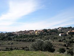
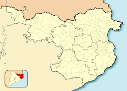
Vilamaniscle is a municipality in the comarca of Alt Empordà, Girona, Catalonia, Spain. It is located in the western part of the Serra de la Baga d'en Ferràn, a branch of the Albera Range. Much of its municipal term is covered with pine and cork oak trees. The main crops are olives and grapes. Local wine is appreciated all over the country. New hosting services are growing due to tourism.
Vilamaniscle is the home for around 120 inhabitants today. The village is a varied picture of some restored homes, other in the process of restoration and still others that wait for their renovation. The majority of the houses were built between the 17th and 19th century. Vilamaniscle is dominated by the "Castell", a three-level unrestored building whose origin is difficult to date. In the prehistoric time people probably lived here, the evidence being the three-metres-high menhir "Pedra Dreta" which is very close to Vilamaniscle.
References[edit]
- ^ "Ajuntament de Vilamaniscle". Generalitat of Catalonia. Retrieved 2015-11-13.
- ^ "El municipi en xifres: Vilamaniscle". Statistical Institute of Catalonia. Retrieved 2015-11-23.
- ^ Municipal Register of Spain 2018. National Statistics Institute.
External links[edit]
- Town Hall webpage
- Government data pages (in Catalan)


